- My Forums
- Tiger Rant
- LSU Recruiting
- SEC Rant
- Saints Talk
- Pelicans Talk
- More Sports Board
- Fantasy Sports
- Golf Board
- Soccer Board
- O-T Lounge
- Tech Board
- Home/Garden Board
- Outdoor Board
- Health/Fitness Board
- Movie/TV Board
- Book Board
- Music Board
- Political Talk
- Money Talk
- Fark Board
- Gaming Board
- Travel Board
- Food/Drink Board
- Ticket Exchange
- TD Help Board
Customize My Forums- View All Forums
- Show Left Links
- Topic Sort Options
- Trending Topics
- Recent Topics
- Active Topics
Started By
Message
 0
0


Posted on 9/10/24 at 1:00 am to RBTiger
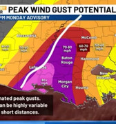
Someone may have already posted. Caparotta did a good little summary this evening. He shows what he thinks we can expect locally. At least what he thinks based on the latest update
https://m.youtube.com/watch?v=poY5PTRM99s&feature=youtu.be
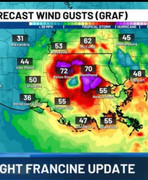
Noon Wednesday
 [/url][/img]
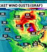
2pm Wednesday
 [/url][/img]
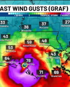
4pm Wednesday
 [/url][/img]
https://m.youtube.com/watch?v=poY5PTRM99s&feature=youtu.be
Noon Wednesday
[/url][/img] 2pm Wednesday
[/url][/img] 4pm Wednesday
[/url][/img] This post was edited on 9/10/24 at 1:12 am
Posted on 9/10/24 at 1:03 am to lsuman25
HAFS-A shifted west and HAFS-B shifted east, but both are into Terrebonne Parish, which is obviously east of the current forecast by quite a bit. The HAFS-A has been a major outlier today with how far east it was taking it, and has come back to the pack some here.
This post was edited on 9/10/24 at 1:05 am
Posted on 9/10/24 at 1:09 am to slackster
The hafs-a had the eye going east of Houma at one point  it was also showing about 950.
Posted on 9/10/24 at 1:10 am to berrycajun
I assume you mean Wednesday??
Posted on 9/10/24 at 1:11 am to BregmansWheelbarrow
Yes. Wednesday. Thx
This post was edited on 9/10/24 at 1:12 am
Posted on 9/10/24 at 1:15 am to berrycajun
I was picking about what a crazy outlier it was, not your situation.
Posted on 9/10/24 at 1:16 am to BregmansWheelbarrow
quote:
The hafs-a had the eye going east of Houma at one point it was also showing about 950.
shite it was south and eventually east of New Orleans. It's still way off of the consensus to the point of being almost unbelievable, but it's not as insane.
Posted on 9/10/24 at 1:18 am to BregmansWheelbarrow
Yeh. & I thought it was going to be even more west. Good news for Lake Charles and their capital one rubble at least.
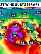
10:30am Morgan city Wednesday
 [/url][/img]
10:30am Morgan city Wednesday
[/url][/img] Posted on 9/10/24 at 1:21 am to berrycajun
The GRAF model comes from IBM, who owns The Weather Channel.
It’s designed to be a legitimate model obviously, but the for-profit nature and conflict of interest always leaves me a little skeptical.
It’s designed to be a legitimate model obviously, but the for-profit nature and conflict of interest always leaves me a little skeptical.
Posted on 9/10/24 at 1:28 am to berrycajun
But at the end of his video he said this is his predicted path as of now —the white line he drew.
 [/url][/img]
that’s a good bit further west than the images that have the eye over Morgan city. So it’s still not locked in (in my opinion, which is not based on science, but rather a recollection of hurricanes doing what they want at the last minute)
[/url][/img] that’s a good bit further west than the images that have the eye over Morgan city. So it’s still not locked in (in my opinion, which is not based on science, but rather a recollection of hurricanes doing what they want at the last minute)
Posted on 9/10/24 at 1:32 am to slackster
Trends are east. NHC won’t budge the track
Posted on 9/10/24 at 1:34 am to slackster
That’s moved east 20 miles
Posted on 9/10/24 at 1:42 am to berrycajun
Wait a minute I didn't think it was supposed to be getting here quite that soon are we supposed to start seeing winds in the greater Baton Rouge area?
Tomorrow evening?
Tomorrow evening?
Posted on 9/10/24 at 1:51 am to X123F45

NHC forecast now noticeably west of early 6z guidance.
6z intensity forecast is down though, which is good.
Posted on 9/10/24 at 2:04 am to slackster
She’s sucking in more dry air delaying intensification. Thats great for LA
Posted on 9/10/24 at 3:09 am to slackster
Blue, green and purple lines can get fricked
Posted on 9/10/24 at 3:12 am to X123F45
quote:
are we supposed to start seeing winds in the greater Baton Rouge area
NHC says 8 am Wednesday.

Posted on 9/10/24 at 3:27 am to Ancient Astronaut
quote:
could see a few power outages but hopefully nothing crazy

 Page 171 of 492

Popular
Back to top