- My Forums
- Tiger Rant
- LSU Recruiting
- SEC Rant
- Saints Talk
- Pelicans Talk
- More Sports Board
- Fantasy Sports
- Golf Board
- Soccer Board
- O-T Lounge
- Tech Board
- Home/Garden Board
- Outdoor Board
- Health/Fitness Board
- Movie/TV Board
- Book Board
- Music Board
- Political Talk
- Money Talk
- Fark Board
- Gaming Board
- Travel Board
- Food/Drink Board
- Ticket Exchange
- TD Help Board
Customize My Forums- View All Forums
- Show Left Links
- Topic Sort Options
- Trending Topics
- Recent Topics
- Active Topics
Started By
Message

 2
2

Posted on 9/9/24 at 11:11 pm to slackster
Can someone explain to me why all of what I circled isn’t purple?
I mean surely somewhere in south LA chances are higher than 5-10%.
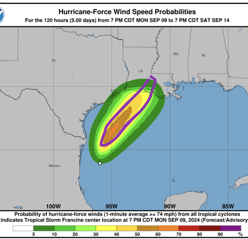
I mean surely somewhere in south LA chances are higher than 5-10%.
Posted on 9/9/24 at 11:12 pm to TDsngumbo
This is a track I been seeing all day St Mary parish landfall

Posted on 9/9/24 at 11:13 pm to TigerNAtux
Speaking of surge flooding, I never thought to check out rain totals. The latest GFS shows my area of Ascension getting nearly 12" of rain between now and Thursday morning.
Posted on 9/9/24 at 11:14 pm to LegendInMyMind
quote:
The eye is starting to look more fully closed now than it has up to this point on radar.
Which is surprising because it looks about as bad on satellite as it has all day.

Posted on 9/9/24 at 11:14 pm to Hamma1122
quote:
This is a track I been seeing all day St Mary parish landfall
St. Mary Parish to Vermillion Bay sure seem to be a hot spot among most models today and tonight.
Posted on 9/9/24 at 11:15 pm to jyoung1
quote:
Can someone explain to me why all of what I circled isn’t purple?
I’m assuming that’s sustained winds? Not sure
Posted on 9/9/24 at 11:15 pm to TigerNAtux
Posted on 9/9/24 at 11:20 pm to jyoung1
quote:
Can someone explain to me why all of what I circled isn’t purple?
I mean surely somewhere in south LA chances are higher than 5-10%.
Well yeah, your map shows that too. The 3rd lightest shade of green is a 20-30% chance, and the yellow along the coast is 30-40% chance.
It's not purple because the storm itself doesn't even have 75 mph winds, so there is obviously a greater than 0% chance that it never gets there. The track uncertainty matters too, particularly when the hurricane force winds may only be a few dozen miles across.
This post was edited on 9/9/24 at 11:22 pm
Posted on 9/9/24 at 11:24 pm to slackster
It’s 120 hours from now with the storm at current intensity, not future intensity, correct?
Posted on 9/9/24 at 11:27 pm to BregmansWheelbarrow
quote:
It’s 120 hours from now with the storm at current intensity, not future intensity, correct?
quote:
These graphics show probabilities of sustained (1-minute average) surface wind speeds equal to or exceeding 64 kt (74 mph). These wind speed probability graphics are based on the official National Hurricane Center (NHC) track, intensity, and wind radii forecasts, and on NHC forecast error statistics for those forecast variables during recent years. Each graphic provides cumulative probabilities that wind speeds of at least 74 mph will occur during cumulative time periods at each specific point on the map. The cumulative periods begin at the start of the forecast period and extend through the entire 5-day forecast period at cumulative 12-hour intervals (i.e., 0-12 h, 0-24 h, 0-36 h, ... , 0-120 h).
It's based on future track, intensity, and NHC historial errors.
Posted on 9/9/24 at 11:34 pm to jyoung1
Because that’s the projected windfield at a single snap shot in time . . . I think
Posted on 9/9/24 at 11:34 pm to slackster
The state has a good stage model but it runs in a supercomputer so you have to wait for the results on delay after each advisory they’re still on 5
https://cera.coastalrisk.live/
https://cera.coastalrisk.live/
Posted on 9/9/24 at 11:40 pm to NolaAg04
Wonder if these Wind gust will hold up??
Fox Weather had BR in the 60-70mph Wind Gust Zone.

Fox Weather had BR in the 60-70mph Wind Gust Zone.
This post was edited on 9/9/24 at 11:58 pm
Posted on 9/9/24 at 11:43 pm to slackster
Thanks!
Posted on 9/9/24 at 11:45 pm to RBTiger
Chris Bruin on The Weather Channel just said Baton Rouge could see the eye
This post was edited on 9/9/24 at 11:50 pm
Posted on 9/9/24 at 11:48 pm to Mr Roboto
shite thought there was a 12am update not sure I can stay awake for a 1am
Posted on 9/9/24 at 11:49 pm to Mr Roboto
quote:
Guy on The Weather Channel just said Baton Rouge could see the eye
Very plausible. The GFS is one of the major global models and it has the eye (or whatever is left of it) passing east of BR. The NHC has it passing slightly west of BR.
Posted on 9/9/24 at 11:50 pm to CE Tiger
quote:
shite thought there was a 12am update not sure I can stay awake for a 1am
1am update will be a position update only. No intensity forecast and no track forecast. Those will come at 4am. Go to bed.

Posted on 9/9/24 at 11:56 pm to slackster
quote:Definitely a little pucker on seeing the GFS track since it puts the center on top of my house.
GFS is one of the major global models and it has the eye (or whatever is left of it) passing east of BR
Although even a path to the west side of BR is troubling since I'd still be in the NE quadrant.
No evacuations, but Demco's refusal to clean ROWs is gonna have our power out for a week or more.

 Page 169 of 492

Popular
Back to top