- My Forums
- Tiger Rant
- LSU Recruiting
- SEC Rant
- Saints Talk
- Pelicans Talk
- More Sports Board
- Fantasy Sports
- Golf Board
- Soccer Board
- O-T Lounge
- Tech Board
- Home/Garden Board
- Outdoor Board
- Health/Fitness Board
- Movie/TV Board
- Book Board
- Music Board
- Political Talk
- Money Talk
- Fark Board
- Gaming Board
- Travel Board
- Food/Drink Board
- Ticket Exchange
- TD Help Board
Customize My Forums- View All Forums
- Show Left Links
- Topic Sort Options
- Trending Topics
- Recent Topics
- Active Topics
Started By
Message
 0
0


Posted on 10/5/20 at 4:36 pm to habz007
Don’t you all get tired of arguing over the same thing in every hurricane thread? Haven’t most of you been here long enough to understand the basics of what’s going on? It’s every storm thread. The same thing every time.
A retarded monkey can understand a forecast map. It’s not that complicated. Jesus.
A retarded monkey can understand a forecast map. It’s not that complicated. Jesus.

Posted on 10/5/20 at 4:36 pm to habz007
quote:
They made the initial 24-48hr cone unnecessarily too tight
They don’t get to make the cone any larger or smaller than one standard deviation of error allows.
Did you read his post?
Posted on 10/5/20 at 4:37 pm to Jake88
quote:
Is the shear currently happening and just waiting on the storm's approach or is it only a projection at this time? What is the certainty of the shear if not already going on?
What’s going steer it north is also going to impart shear, it’s just a matter of how strong the storm and the shear will be at that time. Also how quickly it’s moving.

Posted on 10/5/20 at 4:37 pm to Prominentwon
quote:
Don’t you all get tired of arguing over the same thing in every hurricane thread?
No. It is immensely entertaining every time for me
Posted on 10/5/20 at 4:37 pm to slackster
FWIW
Posted on 10/5/20 at 4:40 pm to SlidellCajun
Thanks
Posted on 10/5/20 at 4:40 pm to rds dc
The storm is rapidly deepening. Water is plenty hot, storm is organized but small and there’s no shear now. It is bombing out.

Posted on 10/5/20 at 4:41 pm to SlidellCajun
Trying to get up to date on this one, what are the predictions for potential intensity at landfall? Seeing the Ms on the forecast but then dropping back to H as it goes further into the gulf. What are the chances it maintains the strength instead of weakening in the gulf?
Posted on 10/5/20 at 4:41 pm to theOG
The cone would be better if they used the ensemble spread.
Posted on 10/5/20 at 4:41 pm to habz007
quote:
I hear you. But just an easy observation, the cone from overnight doesn’t even overlap at all through the region of the Yucatan pass. That’s a mere 18hrs, and the cone completely jumped. Doesn’t mean anything to us here, but the folks in Cancun and Cozumel are probably flipping tables.
The NHC should reconsider making cones for tropical depressions.
The center structure is typically poorly formed and a center relocation (like we saw today with Delta) makes for erratic changes in the 24-48 cone at times.
The logic behind what’s steering the system didn’t change at all, but the system reforming SW requires a SW adjustment of the track.
Posted on 10/5/20 at 4:43 pm to habz007
quote:
They made the initial 24-48hr cone unnecessarily too tight (that’s what she said).
This shite again?
Posted on 10/5/20 at 4:44 pm to Prominentwon
Yes and everybody knows that when they predict NOLA to get a hit 4 days before landfall that it lands well over 50 miles and usually up to 100 miles away.
Posted on 10/5/20 at 4:45 pm to SippyCup
quote:
The cone would be better if they used the ensemble spread.
Alright. 3,000 miles of coast look out!
Posted on 10/5/20 at 4:46 pm to Cosmo
quote:
No. It is immensely entertaining every time for me
Men...world burning..something, something.
Posted on 10/5/20 at 4:47 pm to slackster
quote:
The NHC should reconsider making cones for tropical depressions.
The center structure is typically poorly formed and a center relocation (like we saw today with Delta) makes for erratic changes in the 24-48 cone at times.
The logic behind what’s steering the system didn’t change at all, but the system reforming SW requires a SW adjustment of the track.
Good suggestion.
Posted on 10/5/20 at 4:49 pm to TigahJay
quote:
Trying to get up to date on this one, what are the predictions for potential intensity at landfall?
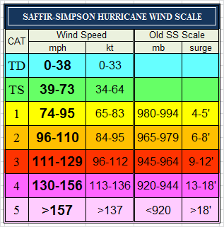
Low end Cat 1 to potentially Cat 3.
quote:
What are the chances it maintains the strength instead of weakening in the gulf?
Seems unlikely to be strengthening into landfall for lots of reasons, so that’s good news. It’s probably going to be weakening into landfall, but how strong it gets will impact how much it weakens into landfall. In other words, weakening from 120kts or 90kts makes a big difference.
Posted on 10/5/20 at 4:53 pm to slackster
quote:
Seems unlikely to be strengthening into landfall for lots of reasons, so that’s good news. It’s probably going to be weakening into landfall, but how strong it gets will impact how much it weakens into landfall. In other words, weakening from 120kts or 90kts makes a big difference.
What also needs to be considered is if it does grow to be a major and stays a major long enough the surge would be severe even if the storm weakens.
Posted on 10/5/20 at 4:55 pm to rds dc
How fricked is br given the current forecast?
This post was edited on 10/5/20 at 4:57 pm
Posted on 10/5/20 at 4:55 pm to rds dc
quote:
Recon extrapolated down to 978ish
Strengthening, even if number is wrong. Not a great look in this location. Should get some interesting recon tonight.

 Page 37 of 601

Popular
Back to top