- My Forums
- Tiger Rant
- LSU Recruiting
- SEC Rant
- Saints Talk
- Pelicans Talk
- More Sports Board
- Coaching Changes
- Fantasy Sports
- Golf Board
- Soccer Board
- O-T Lounge
- Tech Board
- Home/Garden Board
- Outdoor Board
- Health/Fitness Board
- Movie/TV Board
- Book Board
- Music Board
- Political Talk
- Money Talk
- Fark Board
- Gaming Board
- Travel Board
- Food/Drink Board
- Ticket Exchange
- TD Help Board
Customize My Forums- View All Forums
- Show Left Links
- Topic Sort Options
- Trending Topics
- Recent Topics
- Active Topics
Started By
Message
re: Beta - Downgraded to TD - Now Short Break in Storms or Season Over?
Posted on 9/19/20 at 12:53 pm to bayoubengals88
Posted on 9/19/20 at 12:53 pm to bayoubengals88
quote:
I've seen rain on radar sit just east of Baton Rouge all morning. Is that a wall of drier air or something?
I left Prairieville at 4am and drove up to Morganza to teal hunt. When I drove home at 9am I hit rain in almost the exact spot that it stopped on the way there.
 0
0


Posted on 9/19/20 at 12:54 pm to PUB
Posted on 9/19/20 at 12:54 pm to PUB
quote:Uh-oh.
If predictions are as "accurate" as Sally, it hits NOLA area just west of Lake Pontchartrain.
NOW you've gone and done it....
Posted on 9/19/20 at 12:55 pm to PUB
quote:
it hits NOLA area just west of Lake Pontchartrain.
That's in the cone fwiw

Posted on 9/19/20 at 12:57 pm to Duke
This storm is obviously thinking... I don't know what the frick he's thinking.
Posted on 9/19/20 at 12:59 pm to LSUBoo
quote:
This storm is obviously thinking... I don't know what the frick he's thinking.
such a Beta
Posted on 9/19/20 at 1:01 pm to LSUBoo
quote:
This storm is obviously thinking... I don't know what the frick he's thinking.
Welcome to my world.
Posted on 9/19/20 at 1:15 pm to Duke
It's fake thinking of pretending to keep you thinking it might stay in the cone.
Posted on 9/19/20 at 1:16 pm to Duke
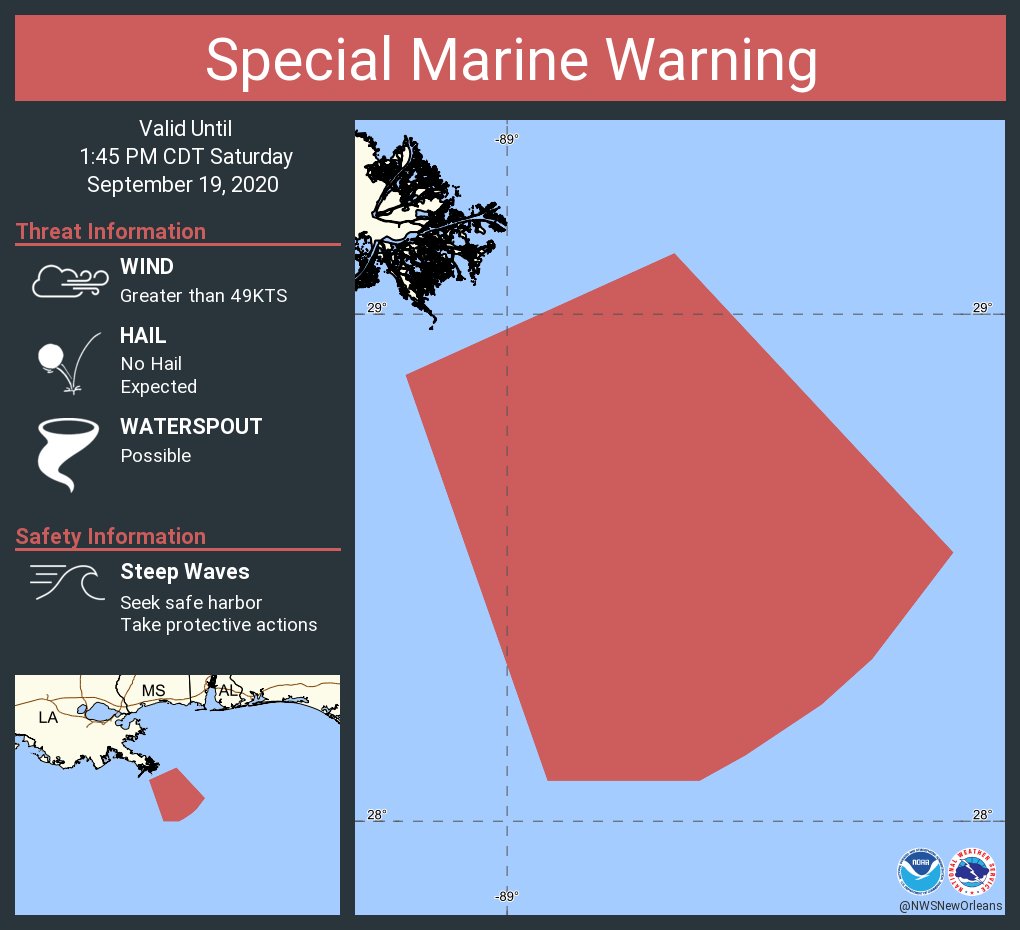
Assumption-St. James-St. John The Baptist-Upper Lafourche-
St. Charles-Upper Jefferson-Orleans-Upper Plaquemines-
Upper St. Bernard-Upper Terrebonne-Lower Terrebonne-
Lower Lafourche-Lower Jefferson-Lower Plaquemines-
Lower St. Bernard-
River Parishes/Houma-Thibs/New Orleans Heads Up.
...WIND ADVISORY IN EFFECT UNTIL 7 AM CDT SUNDAY...
* WHAT...East winds around 20 mph with gusts up to 30 mph
expected.
* WH0ERE...Portions of southeast Louisiana, generally south of I-10.
* WHEN...Until at least 7 AM CDT Sunday.
PRECAUTIONARY/PREPAREDNESS ACTIONS...
Use extra caution when driving, especially if operating a high
profile vehicle. Secure outdoor objects.
Ok, so not a big deal but still spreading the good word it'll be a little breezy tonight as the rain rolls in.
Posted on 9/19/20 at 1:23 pm to Duke
Could use some of that rain here.  North of BR.

Posted on 9/19/20 at 1:29 pm to Duke
Not sure why but there isn't much of any urgency at all for this storm along the middle coast here in Texas. Hope the projections of it weakening before landfall and it coming in around Matagorda hold up or a lot of folks in Port A and Rockport are going to get a big bad surprise. Given 2020 so far I'm expecting the worse and hoping for better.
Posted on 9/19/20 at 1:29 pm to Duke

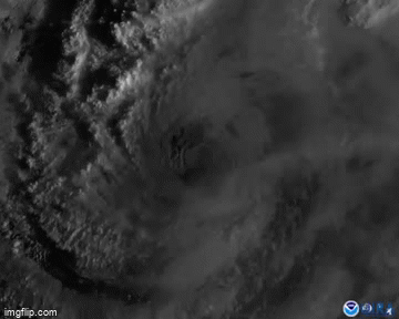
So still sheared to shite this afternoon, but it has managed to keep some convection over/near the center and if you're watching WV you can see expansion to the west in the last few frames. West turn, confirmed by the NHC, and also by what I'm seeing here.
We're entering the window for Beta to reach hurricane as this west turn should lead to the best conditions it'll see for intensification. Shear probably still there but lessened, not quite close enough to full suck in the dry air. The closer it moves to the coast, the more the dry air is going to be a challenge.
Modeling this afternoon sticks with the NHC idea of this west turn today and then a NE turn starting Wednesday. The HWRF and Euro are really starting to bury this into Texas, while the rest of them want just inland or a coast rider. Like the trend of getting this well inland for our Lake Charles people and coastal Texas people.
Just watching the trends at this point and waiting for all of the ensembles to come out while enjoying a nice rainy day in NOLA.
ETA: The UKMet, the last real southern and eastern outlier, has come in to the consensus path too and puts it inland enough to very much weaken it.
This post was edited on 9/19/20 at 1:52 pm
Posted on 9/19/20 at 1:31 pm to TxWadingFool
quote:
Hope the projections of it weakening before landfall and it coming in around Matagorda hold up or a lot of folks in Port A and Rockport are going to get a big bad surprise. Given 2020 so far I'm expecting the worse and hoping for better.
That's not great to hear. It does make sense to weaken on final coastal approach but I sure as shite wouldn't be banking on it.

Posted on 9/19/20 at 1:35 pm to Duke
quote:
Like the trend of getting this well inland for our Lake Charles people and coastal Texas people.
This
Posted on 9/19/20 at 1:37 pm to Cosmo
Posted on 9/19/20 at 1:50 pm to tigerbutt
quote:
Anyone else feels like this storm isn’t going to the Texas coast but rather to LA?
There it is

Posted on 9/19/20 at 1:56 pm to Bobby OG Johnson
That's badass.
Posted on 9/19/20 at 1:56 pm to deltaland
Bingo? 
Posted on 9/19/20 at 2:01 pm to tigerbutt
I feel like a tropical storm could be off the coast of South Carolina and project towards the East Coast and some of our TD wishcasters would tell us it’s definitely hitting Louisiana
Posted on 9/19/20 at 2:03 pm to Klark Kent
fricking Irma.

 Page 37 of 63

Popular
Back to top