- My Forums
- Tiger Rant
- LSU Recruiting
- SEC Rant
- Saints Talk
- Pelicans Talk
- More Sports Board
- Fantasy Sports
- Golf Board
- Soccer Board
- O-T Lounge
- Tech Board
- Home/Garden Board
- Outdoor Board
- Health/Fitness Board
- Movie/TV Board
- Book Board
- Music Board
- Political Talk
- Money Talk
- Fark Board
- Gaming Board
- Travel Board
- Food/Drink Board
- Ticket Exchange
- TD Help Board
Customize My Forums- View All Forums
- Show Left Links
- Topic Sort Options
- Trending Topics
- Recent Topics
- Active Topics
Started By
Message
re: Anyone else obsessed with maps both as a kid and adult?
Posted on 7/22/19 at 9:09 am to Funky Tide 8

Posted on 7/22/19 at 9:09 am to Funky Tide 8
Love Maps and Compass' too... Check out this map I own.
Normandy Invasion Map.. Printed Jan '44
 [/img]
Normandy Invasion Map.. Printed Jan '44
[/img] 1
1

Posted on 7/22/19 at 9:12 am to WWII Collector
Man, not one mention of gas stations giving away maps...
and, how good were y'all at re-folding?
and, how good were y'all at re-folding?
Posted on 7/22/19 at 9:26 am to TigerRob20
Maps are simply wonderful. I think I discovered them when I was in the second grade and we drove to see my Grandmother in Illinois. (When we got home, I kept a hold on the Atlas and figured out how to drive to Key West and then to Cuba by ferry (yes, I am that old). Of course, my interest wasn't shared by my parents.
Let me introduce you to the Perry-Castaneda map collection at the University of Texas.
Perry-Castaneda Map Collection
You could spends months and still find new old maps at this site. I used it when the lava was flowing in Hawaii because they had the daily updates. I used to it trace some highways from the 1890s on topo maps. It is a time sink, and their updates "in the news" are superb.
Addtional historic topo maps are here, and this site gives you a choice of how refined you want the images.
USGS historical topo map portal
Google maps for daily searches and internationally, to see where things happened (and often when you switch to satellite at close up, you'll see why). One of the neater things I stumbled on was an abandoned naval base on the shore of the Korean Peninsula.

Posted on 7/22/19 at 10:04 am to facher08
quote:
Ha. No they don't. They they follow the solid blue line or listen for the voice to tell them where to go.
Do you know this from personal experience, or are you simply regurgitating what your Facebook friends fed you?

Posted on 7/22/19 at 10:06 am to dallastiger55
quote:
I might regret it 30 minutes into the trip, but in the next 12-18 months I want to do an old school Griswald family car trip Rent a van and just go for 7-10 days and hit up multiple states. My friend did it and said they would do 2 hours of no phones and then 1 hour with phones. They had to talk and do road games Sounds fun
We did this when I was young. I regret that we have not really been able to do this with my family, and that opportunity is now passed as one of mine is early 20s and married, and his brother is 20. :(

Posted on 7/22/19 at 10:06 am to dallastiger55
State farm atlas was the GOAT. We drove everywhere on vacations growing up and I would look at it almost the whole time when my parents weren't using it to navigate.
I'll oftentimes open up Google maps and just explore stuff too. It's so fun.
I'll oftentimes open up Google maps and just explore stuff too. It's so fun.

Posted on 7/22/19 at 10:08 am to Hangover Haven
quote:
and, how good were y'all at re-folding?

This post was edited on 7/22/19 at 10:09 am

Posted on 7/22/19 at 10:11 am to TH03
I’m not that interested in new age maps. I like the OLD maps. Like, olddddd old. Like dis

Posted on 7/22/19 at 10:12 am to facher08
quote:
Ha. No they don't. They they follow the solid blue line or listen for the voice to tell them where to go.
I would put my sense of direction up against you or anyone else at any time, baw.

Posted on 7/22/19 at 10:13 am to dallastiger55
Yes.
And my kid has inherited it too, he is mesmerized by maps at age 4.
When I was a kid on road trips, I took over navigation duty from my mom at like age 7.
And my kid has inherited it too, he is mesmerized by maps at age 4.
When I was a kid on road trips, I took over navigation duty from my mom at like age 7.
This post was edited on 7/22/19 at 10:14 am
Posted on 7/22/19 at 10:13 am to beerJeep
I *allegedly* used to use a combination of maps and google maps to find fishing holes. I still get on google earth and look around from time to time.
I would definitely be interested in taking a trip using only a paper map.
I would definitely be interested in taking a trip using only a paper map.
Posted on 7/22/19 at 10:14 am to beerJeep
Those are cool too. I've got a pretty cool map from the 1940s hung in our living room. It was my grandfather's. It's part of a series and I want to try to track down the rest. Mine is Mexico/Central America/West Indies.
Posted on 7/22/19 at 10:16 am to beerJeep
Posted on 7/22/19 at 10:16 am to dallastiger55
I am big time. My buddies and lady actually make fun of me for knowing extremely obscure towns and their locations. It's been good for ice breaking however.
Posted on 7/22/19 at 10:16 am to dallastiger55
Absolutely. Still am.
Topo maps in particular
Topo maps in particular
Posted on 7/22/19 at 10:17 am to dallastiger55
I'm fascinated by the many different map projections you can do of the globe:
An Australian "Corrective" south up projection-

Dymaxion project, with minimal distortion-

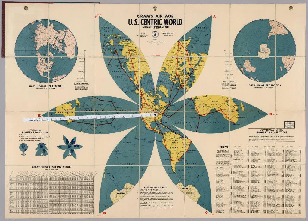
Gingery projection, proving Maine is the closest US state to Africa-
An Australian "Corrective" south up projection-
Dymaxion project, with minimal distortion-
Gingery projection, proving Maine is the closest US state to Africa-
Posted on 7/22/19 at 10:19 am to Joshjrn
quote:
They’ve spent their entire lives looking at maps on their phone. Do you honestly believe their incorporating cross streets and landmarks would be beyond them?
I get calls from people daily who can't find our facility (it's extremely easy) because the physical address doesn't jive with google maps.

Posted on 7/22/19 at 10:21 am to FeauxPaw
quote:
Gingery projection, proving Maine is the closest US state to Africa-
Wow, never seen that before, very cool.
Posted on 7/22/19 at 10:22 am to dallastiger55
I always try and find roads that lead to super remote areas like northernmost Canada and imagine some family humping up from Toronto visiting Grandma or something in a place humans shouldn't be able to live in 

 Page 3 of 6

Popular
Back to top