- My Forums
- Tiger Rant
- LSU Recruiting
- SEC Rant
- Saints Talk
- Pelicans Talk
- More Sports Board
- Fantasy Sports
- Golf Board
- Soccer Board
- O-T Lounge
- Tech Board
- Home/Garden Board
- Outdoor Board
- Health/Fitness Board
- Movie/TV Board
- Book Board
- Music Board
- Political Talk
- Money Talk
- Fark Board
- Gaming Board
- Travel Board
- Food/Drink Board
- Ticket Exchange
- TD Help Board
Customize My Forums- View All Forums
- Show Left Links
- Topic Sort Options
- Trending Topics
- Recent Topics
- Active Topics
Started By
Message

2 Apr Severe Weather Potential now in more Eastern areas than Tue
Posted on 4/1/25 at 1:15 pm
Posted on 4/1/25 at 1:15 pm
April ramps up the weather season. And always brings out those who say its crying wolf too much. I think like everything else there are more people covering weather due to social media and Podcasts. So you have to soft through them and learn who the better coverage folks are.
Side note: The bill in OK to require licenses to chase never made it out of committee, so can’t be done this year - would be next year at earliest to get back on docket.
Some words of wisdom
NWS Norman
@NWSNorman
We see the comments after every severe weather event, things like "we were in an enhanced risk and we didn't even get a storm." Here's some reminders about what those outlooks mean (and don't mean) hopefully to help everyone understand their purpose a little better.
This post was edited on 4/2/25 at 1:13 pm
 16
16

Posted on 4/1/25 at 1:16 pm to OU Guy
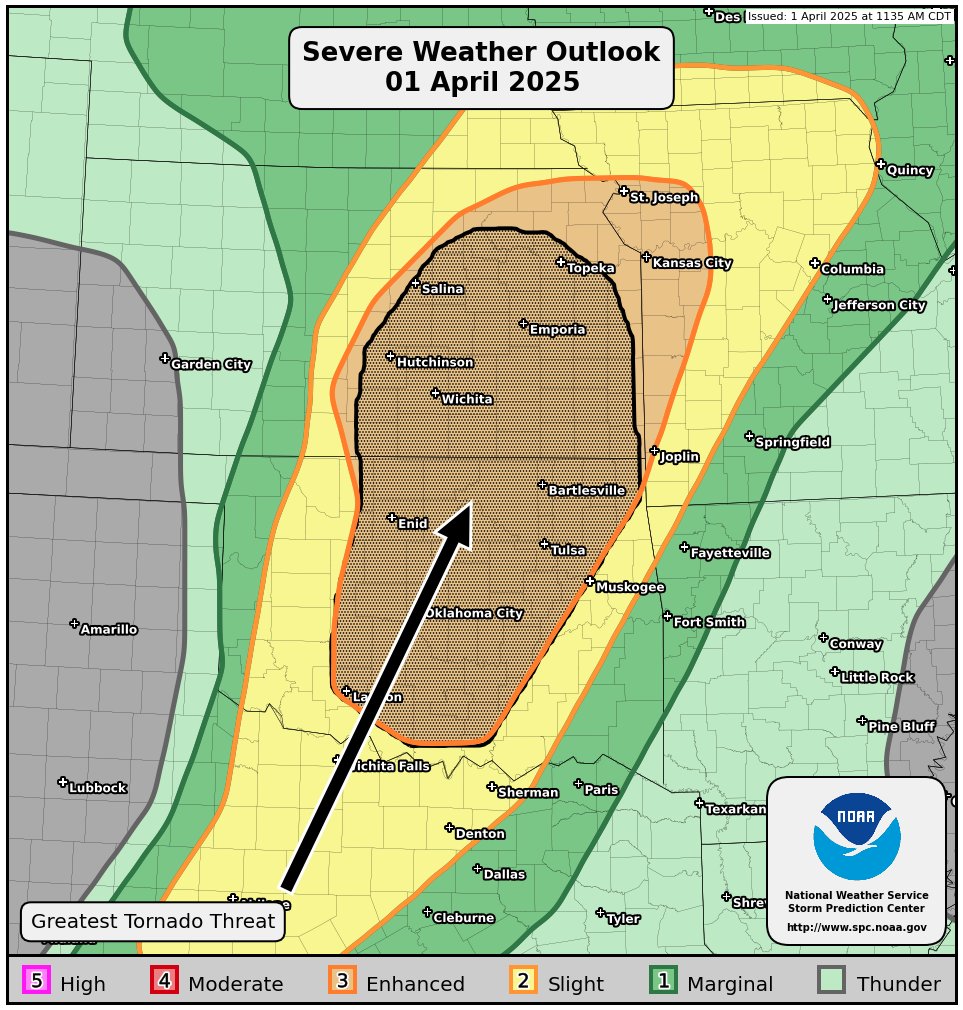
Today:
Posted on 4/1/25 at 1:22 pm to OU Guy
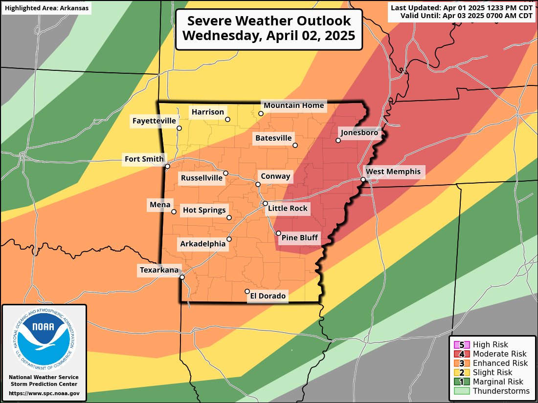
And tomorrow for those eastward
Posted on 4/1/25 at 1:36 pm to OU Guy
quote:
US National Weather Service Lower Mississippi River Forecast Center
·
Heavy rain in the next 120 hours has the potential to lead to a Generational Flood Event, with the possibility of record high river stages in AR, MO, TN and MS.

Posted on 4/1/25 at 1:38 pm to Jim Rockford

Posted on 4/1/25 at 1:39 pm to OU Guy
quote:
1 Apr Severe Weather Potential

Posted on 4/1/25 at 1:47 pm to Jim Rockford
Imma be on my roof with one of those newfangled NY Yankees bats trying to fend off the baseball hail tonight, I heard they work better.

Posted on 4/1/25 at 2:02 pm to OU Guy
Oh they bumped up the risk for tomorrow in DFW? I thought it was mostly slight for the metroplex. Yee haw.
Posted on 4/1/25 at 2:11 pm to 50_Tiger
David Payne
@tornadopayne
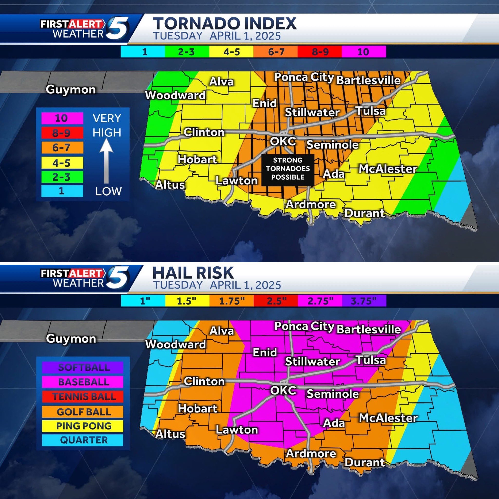
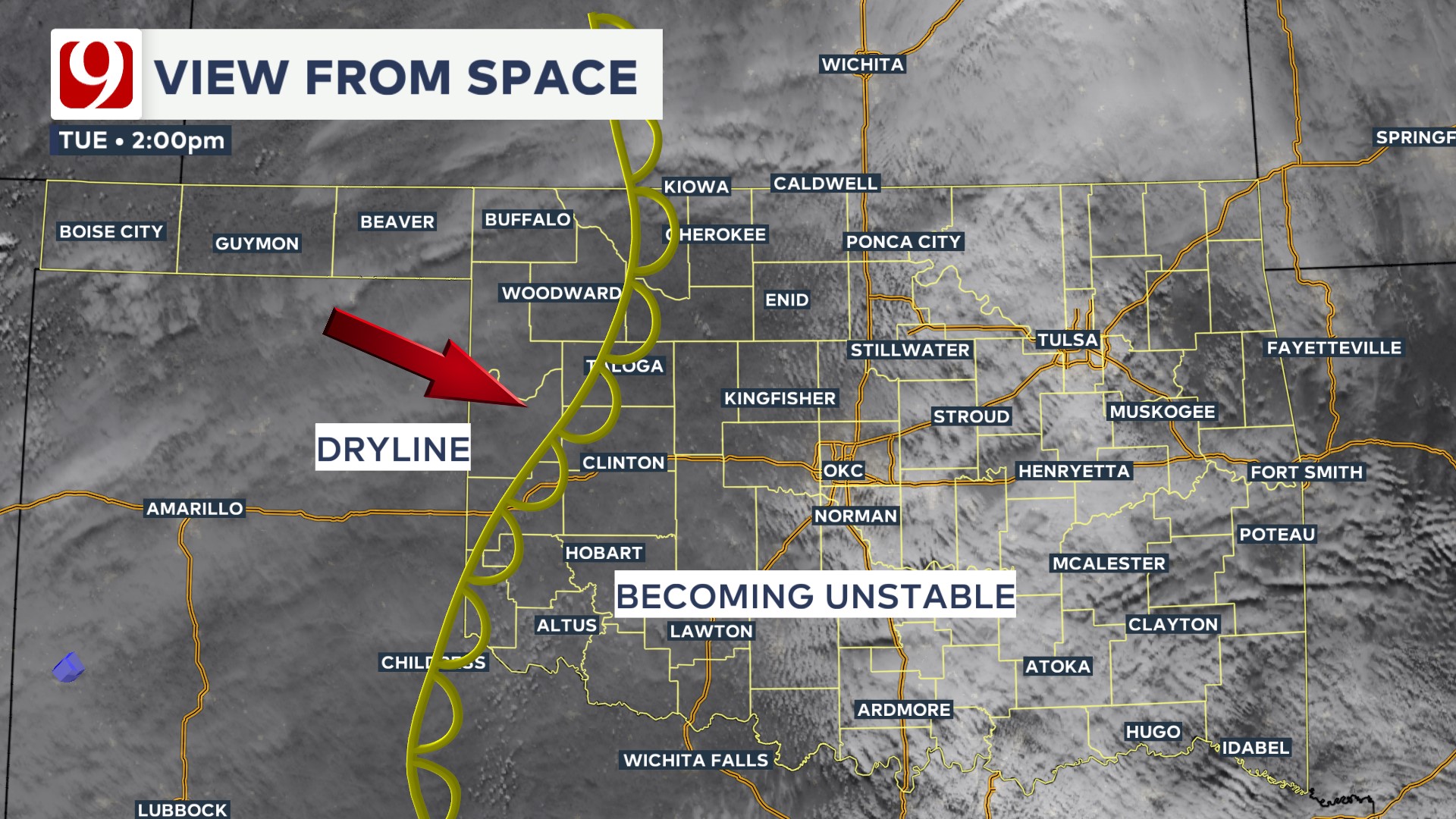
Severe Wx Threat continues for late afternoon & this evening. We're seeing clouds give way to sunshine & temps heating up. This, along with increasing moisture, is making the atmosphere very unstable. Isolated severe storms could develop by 5 pm just west of the metro (OKC).
@tornadopayne
Severe Wx Threat continues for late afternoon & this evening. We're seeing clouds give way to sunshine & temps heating up. This, along with increasing moisture, is making the atmosphere very unstable. Isolated severe storms could develop by 5 pm just west of the metro (OKC).
Posted on 4/1/25 at 2:23 pm to OU Guy
Oklahoma Board
Posted on 4/1/25 at 2:29 pm to OU Guy
The flood threat is going to be a problem with this one. Some places, depending on exactly where this front stalls, could see upwards of a foot of rain through Sunday.
This post was edited on 4/1/25 at 2:31 pm
Posted on 4/1/25 at 3:27 pm to LegendInMyMind
Craig Ceecee, Ph.D.
@CC_StormWatch
A #tornado watch will likely be needed in western/central Oklahoma and western North Texas by early this evening, however, the timing is uncertain as it depends on how things behave on the dryline. If they do develop, significant tornadoes are possible.
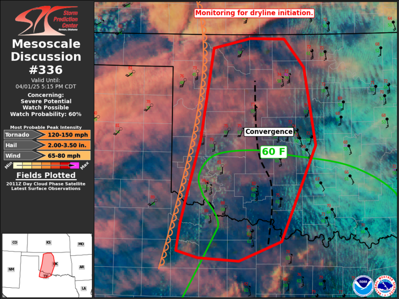
@CC_StormWatch
A #tornado watch will likely be needed in western/central Oklahoma and western North Texas by early this evening, however, the timing is uncertain as it depends on how things behave on the dryline. If they do develop, significant tornadoes are possible.
Posted on 4/1/25 at 3:29 pm to OU Guy
I do think it would be helpful to put the main impacted areas in the thread title

Posted on 4/1/25 at 4:00 pm to OU Guy
I was driving across i-10e between Benson and Wilcox AZ and saw a huge dust cloud coming north - quickly found a truck stop and got parked. Hurricane force wind gusts with 30-40 mph steady. Visibility is less than 1/4 mile.
Posted on 4/1/25 at 4:02 pm to Horsemeat
quote:
I was driving across i-10e between Benson and Wilcox AZ and saw a huge dust cloud coming north - quickly found a truck stop and got parked. Hurricane force wind gusts with 30-40 mph steady. Visibility is less than 1/4 mile.
You had yourself a close encounter with a Haboob!

Posted on 4/1/25 at 4:12 pm to LegendInMyMind
What a Haboob is?
Posted on 4/1/25 at 4:12 pm to deeprig9
Dust storm. Very large dust storm
This post was edited on 4/1/25 at 4:13 pm
Posted on 4/1/25 at 4:13 pm to OU Guy
I have a good buddy in Northeast Arkansas. I sent him this link so he can follow along as the weather goes through. You find great information in these threads a lot of times before local meteorologists.
Posted on 4/1/25 at 4:33 pm to SteelerBravesDawg
quote:Yep - and about 20 minutes after i parked there was a huge wreck east of Wilcox where I would have been had I not stopped. Interstate 10 is closed over there now.
Dust storm. Very large dust storm
+1 smart point to this trucker.
Posted on 4/1/25 at 4:38 pm to Horsemeat
Good instincts.

 Page 1 of 4

Popular
Back to top