- My Forums
- Tiger Rant
- LSU Recruiting
- SEC Rant
- Saints Talk
- Pelicans Talk
- More Sports Board
- Fantasy Sports
- Golf Board
- Soccer Board
- O-T Lounge
- Tech Board
- Home/Garden Board
- Outdoor Board
- Health/Fitness Board
- Movie/TV Board
- Book Board
- Music Board
- Political Talk
- Money Talk
- Fark Board
- Gaming Board
- Travel Board
- Food/Drink Board
- Ticket Exchange
- TD Help Board
Customize My Forums- View All Forums
- Show Left Links
- Topic Sort Options
- Trending Topics
- Recent Topics
- Active Topics
Started By
Message
Tornado! High Risk Day w/ 3 Active PDS Watches
Posted on 1/20/17 at 6:45 pm
Posted on 1/20/17 at 6:45 pm


This post was edited on 1/22/17 at 3:53 pm
 20
20


Posted on 1/20/17 at 6:48 pm to rds dc
Maybe it will blow that arsehole off the bridge
This post was edited on 1/20/17 at 6:50 pm
Posted on 1/20/17 at 6:48 pm to rds dc
Yea, but what does peej say?
Posted on 1/20/17 at 6:50 pm to rds dc
North La or South?
It really does matter.
It really does matter.

Posted on 1/20/17 at 7:13 pm to rds dc
quote:
Tornado!
Where?

Posted on 1/20/17 at 7:33 pm to rds dc
Everyone stay safe 

Posted on 1/20/17 at 8:01 pm to rds dc
Alabama is supposed to be involved in a couple of instances over the weekend.
RDS, are you familiar with James Spann?
RDS, are you familiar with James Spann?

Posted on 1/20/17 at 8:43 pm to rds dc
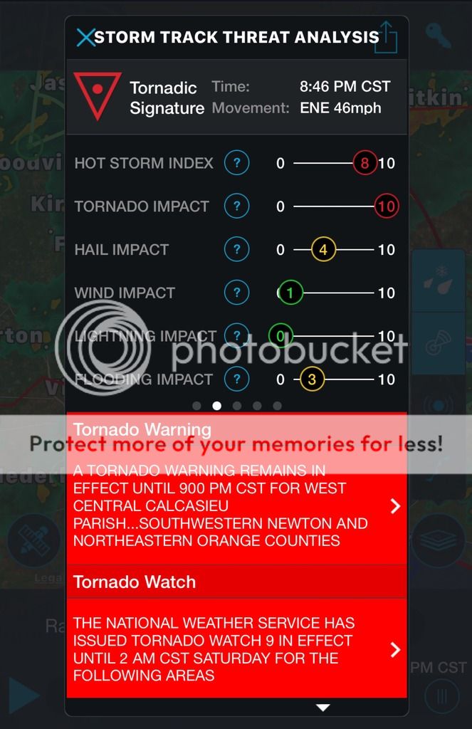
Got a clear hook echo with debris signature associated with that warning. So far it's only radar indicated, but looks like it could be confirmed soon:
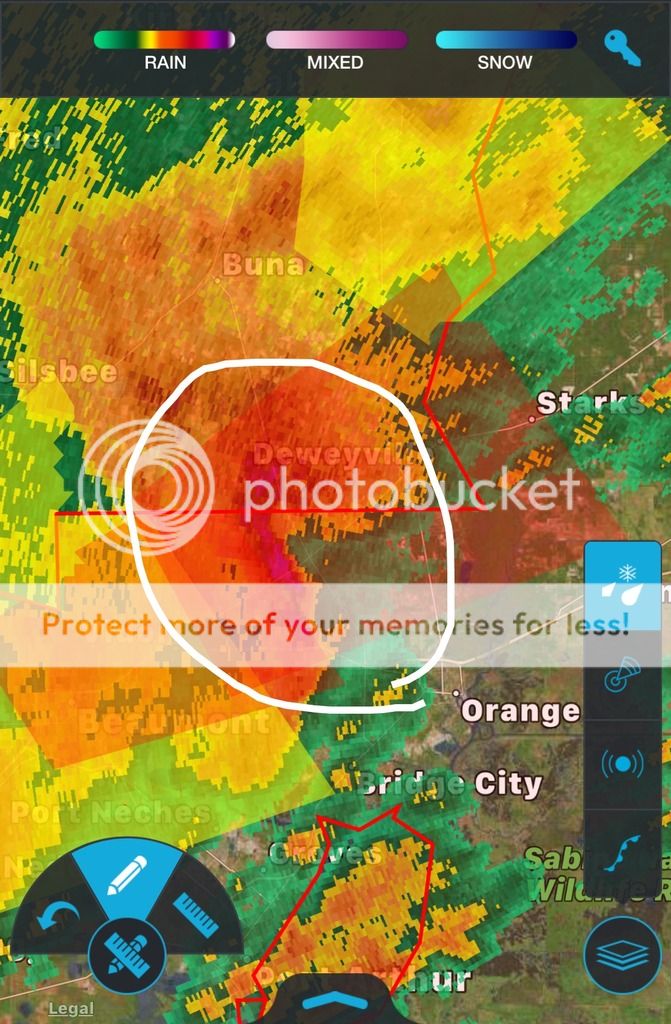
ETA: its not as defined as far as radar reflectivity anymore, but they keep extending the warning area further and further northeast so there must be something to this. Storm (the app) is also picking up a tornadic signature with its in-house metrics, which is usually extremely reliable. I've seen it find tornadic signatures 10+ minutes before warnings were issued many many times.
ETA: its not as defined as far as radar reflectivity anymore, but they keep extending the warning area further and further northeast so there must be something to this. Storm (the app) is also picking up a tornadic signature with its in-house metrics, which is usually extremely reliable. I've seen it find tornadic signatures 10+ minutes before warnings were issued many many times.
This post was edited on 1/20/17 at 9:07 pm
Posted on 1/20/17 at 9:21 pm to rds dc
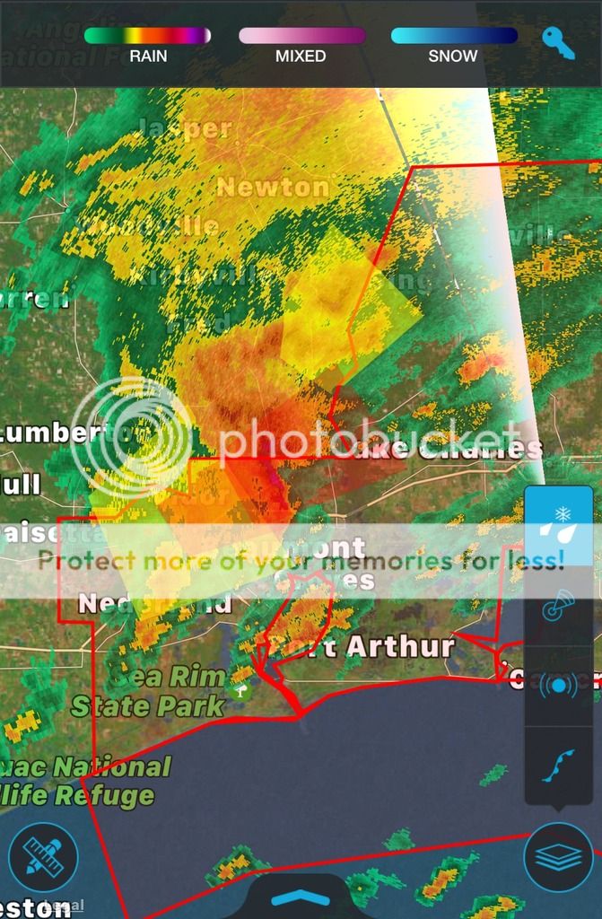
Definitely some potential for more rotation to develop in several places, kinda odd looking velocity right now.

Posted on 1/20/17 at 10:08 pm to rds dc
ZCZC SPCPWOSPC ALL
WOUS40 KWNS 210337
ALZ000-LAZ000-MSZ000-211200-
PUBLIC SEVERE WEATHER OUTLOOK
NWS STORM PREDICTION CENTER NORMAN OK
0937 PM CST FRI JAN 20 2017
...Severe thunderstorms expected over parts of the overnight...
* LOCATIONS...
Southern Louisiana
Southern Mississippi
Southwestern Alabama
* HAZARDS...
A few intense tornadoes
Scattered damaging winds
Isolated large hail up to baseball size
* SUMMARY...
Scattered severe storms are expected to continue developing this
evening across southwestern Louisiana, and spread across the
lower Mississippi Valley and into Alabama and the Florida
Panhandle tonight through Saturday morning. A few tornadoes,
some of which could be strong, large hail and damaging winds
will all be possible.
Preparedness actions...
Tornadoes at night can be particularly dangerous because they
are usually fast-moving and difficult to see. Stay tuned to
NOAA Weather Radio, weather.gov, or other media for watches and
warnings. A tornado watch means that conditions are favorable
for tornadoes to form during the next several hours. If a tornado
warning is issued for your area, move to a place of safety,
ideally in a basement or interior room on the lowest floor of a
sturdy building.
&&
..Edwards.. 01/21/2017
$$
Posted on 1/20/17 at 10:15 pm to rds dc
Damn sons
shite getting real tonight down here huh.
shite getting real tonight down here huh.

Posted on 1/21/17 at 9:45 am to rds dc
The Hattisburg area got hit pretty bad with tornadoes overnight

Posted on 1/21/17 at 11:47 am to rds dc
Apparently local Hattiesburg news warned people around 3am before the NWS was able to. William and Cary medical school was hit and may be shut down for a while.
Posted on 1/21/17 at 12:06 pm to rds dc
Ooooooh haaaaaaail nawwww


Posted on 1/21/17 at 2:39 pm to rds dc
Just launched a balloon at ulm. should have upper air charts available in a minute,

Posted on 1/21/17 at 4:10 pm to rds dc
Here to pop your bubble but from Alexandria down to the LA coast aren't getting anything
Posted on 1/21/17 at 4:20 pm to rds dc
Expecting some bad hail in southwest and central Arkansas. Be safe out there folks.

Posted on 1/21/17 at 7:52 pm to rds dc
Screw it. I'm drinking

 Page 1 of 2

Popular
Back to top