- My Forums
- Tiger Rant
- LSU Recruiting
- SEC Rant
- Saints Talk
- Pelicans Talk
- More Sports Board
- Fantasy Sports
- Golf Board
- Soccer Board
- O-T Lounge
- Tech Board
- Home/Garden Board
- Outdoor Board
- Health/Fitness Board
- Movie/TV Board
- Book Board
- Music Board
- Political Talk
- Money Talk
- Fark Board
- Gaming Board
- Travel Board
- Food/Drink Board
- Ticket Exchange
- TD Help Board
Customize My Forums- View All Forums
- Show Left Links
- Topic Sort Options
- Trending Topics
- Recent Topics
- Active Topics
Started By
Message
re: Hurricane Season - Nicole only 2nd Cat 3 for Bermuda
Posted on 8/22/16 at 11:30 am to rds dc
Posted on 8/22/16 at 11:30 am to rds dc
99L really neads a recon flight so some real data can be put into the models. It's a big system so it will take a while to get going but once it does it can be resistant to dry air and shear and take longer to weaken.
90L will likely be named TD 7 at the evening advisory and Gaston by later tonight
90L will likely be named TD 7 at the evening advisory and Gaston by later tonight
 2
2


Posted on 8/22/16 at 1:28 pm to Mudminnow
no idea how 90L isn't a depression yet.
latest satellite imagery is looking better and better

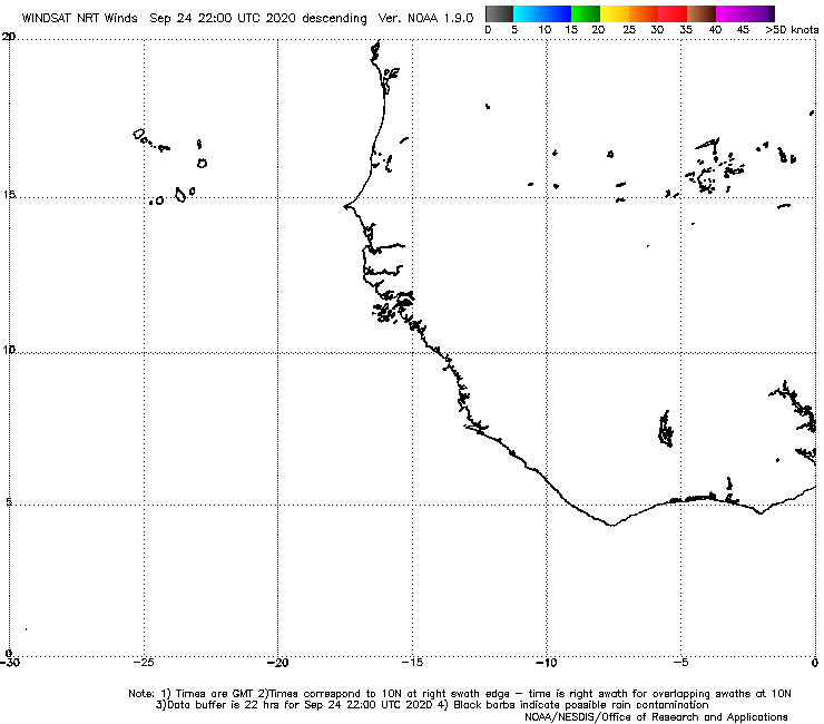
last two windsat passes have had a closed circulation
latest satellite imagery is looking better and better
last two windsat passes have had a closed circulation
Posted on 8/22/16 at 1:28 pm to Mudminnow
quote:
99L really neads a recon flight so some real data can be put into the models.
recon is scheduled to go out to 99L tomorrow.
This post was edited on 8/22/16 at 1:29 pm
Posted on 8/22/16 at 1:30 pm to baytiger
quote:
baytiger
Posted on 8/22/16 at 2:01 pm to Mudminnow
Heyy guyysss.


Posted on 8/22/16 at 2:02 pm to GEAUXmedic
Posted on 8/22/16 at 2:05 pm to GEAUXmedic
Too early but I don't like how the models keep pushing it more towards the gulf. Would be nice if some miracle happens and just pushes it out to sea. Nobody needs this crap right now.
Posted on 8/22/16 at 2:07 pm to deuce985
Yeah that's a little too close for comfort.
Posted on 8/22/16 at 2:09 pm to GEAUXmedic
LOL! For real though i hope recon does not cancel their mission tomorrow at the very least i hope they go sample the atmosphere to hopefully give better data put into the models.

Posted on 8/22/16 at 2:11 pm to Jim Rockford
Even at that distance it'll bring a LOT of unwanted rain to the area. I'm holding on to hope that they'll either turn northward out to sea/along the east coast, or die out with the unfavorable conditions. The last thing the southern half of LA and the gulf coast region needs is more heavy rain.
Posted on 8/22/16 at 2:15 pm to RazorBroncs
That's what I'm saying even if it doesn't turn out to be a major threat if it hits a location anywhere on the gulf coast SE Louisiana is still going to get unfavorable rain bands even though they're on the weak side. Some parts haven't even fully drained yet. Just go away please. My neighborhood is empty.
Posted on 8/22/16 at 2:24 pm to deuce985
Hold up, if it took that exact path, at that strength, and that size, SELA wouldn't see any catastrophic rains, nothing more than we typically see in the afternoon.
Posted on 8/22/16 at 2:26 pm to GEAUXmedic
I am assuming the colors on the right represent wind speed?
This post was edited on 8/22/16 at 2:28 pm
Posted on 8/22/16 at 2:27 pm to GEAUXmedic
But the next run may push it further west. That's what we're worried about.
Posted on 8/22/16 at 2:28 pm to GeauxMatt624
quote:
I am assuming the colors on the right represent wind speed?
Those are the winds in knots at 1.5 km high. Surface winds would be much lower, but the pressure equals a cat 3- borderline cat 4 storm.
This post was edited on 8/22/16 at 2:32 pm
Posted on 8/22/16 at 2:28 pm to GeauxMatt624
Correct i believe that is the wind speed.
Posted on 8/22/16 at 2:42 pm to lsuman25
UKMET is identical, up to 168 hours


Posted on 8/22/16 at 2:43 pm to GEAUXmedic
This is what Katrina was supposed to do...
Posted on 8/22/16 at 2:44 pm to Athis
quote:
This is what Katrina was supposed to do...
Dont say that name, people will lose their shite.

Posted on 8/22/16 at 3:07 pm to GEAUXmedic

 Page 3 of 19

Popular
Back to top