- My Forums
- Tiger Rant
- LSU Recruiting
- SEC Rant
- Saints Talk
- Pelicans Talk
- More Sports Board
- Fantasy Sports
- Golf Board
- Soccer Board
- O-T Lounge
- Tech Board
- Home/Garden Board
- Outdoor Board
- Health/Fitness Board
- Movie/TV Board
- Book Board
- Music Board
- Political Talk
- Money Talk
- Fark Board
- Gaming Board
- Travel Board
- Food/Drink Board
- Ticket Exchange
- TD Help Board
Customize My Forums- View All Forums
- Show Left Links
- Topic Sort Options
- Trending Topics
- Recent Topics
- Active Topics
Started By
Message
 2
2

Posted on 6/13/15 at 5:52 pm to jlntiger
Gustav was worse than Rita or Katrina if we are talking about impacts to Baton Rouge 
Posted on 6/13/15 at 7:01 pm to LSU1NSEC
where is this thing supposed to be on Monday?
Posted on 6/13/15 at 7:15 pm to LSU1NSEC
not a good time for me to be in the middle of the Gulf.....
Posted on 6/13/15 at 7:18 pm to CptBengal
I was w/o power for 6 days for Katrina and 2 for Rita in BR.
Posted on 6/13/15 at 7:21 pm to bubbz
I know this is a lot to ask of the OT, but can we possibly please keep threads like this to discussions about storm development? I'm not surprised really that it went off topic, but damn, there is too much BS in this thread.
Posted on 6/13/15 at 7:26 pm to notiger1997
That's what the RA button is for
Posted on 6/13/15 at 7:29 pm to CptBengal
TROPICAL WEATHER OUTLOOK
NWS NATIONAL HURRICANE CENTER MIAMI FL
800 PM EDT SAT JUN 13 2015
For the North Atlantic...Caribbean Sea and the Gulf of Mexico:
An area of low pressure located over the Yucatan Peninsula is
producing a large area of showers and thunderstorms and winds to
near gale force over portions of the northwestern Caribbean Sea and
southeastern Gulf of Mexico as it interacts with an upper-level
trough. Environmental conditions should support some development of
this system after it moves over the southwestern Gulf of Mexico
Sunday and across the northwestern Gulf of Mexico through Tuesday.
Regardless of development, heavy rains are possible over portions of
the Yucatan Peninsula through Sunday. An Air Force Reserve
Hurricane Hunter aircraft is scheduled to investigate this system
Sunday afternoon, if necessary.
Posted on 6/13/15 at 7:30 pm to RATeamWannabe
Maps, show me maps!
Posted on 6/13/15 at 7:32 pm to LSU1NSEC
Thanks man, internet is slooow out here. Good to know what the topic is going to be at the morning meeting tomorrow, lol.
Looks like I'm pretty much boned on Monday morning.
Looks like I'm pretty much boned on Monday morning.
Posted on 6/13/15 at 7:33 pm to GeauxMariners
quote:
Maps, show me maps!
Not allowed by TigahRag. No maps, commentary, articles, speculation allowed unless you have a PHD in this shite.
Posted on 6/13/15 at 7:40 pm to CptBengal
quote:
Thanks man, internet is slooow out here. Good to know what the topic is going to be at the morning meeting tomorrow, lol.
Looks like I'm pretty much boned on Monday morning.
Probably be a lot more info coming out tomorrow on it.
Posted on 6/13/15 at 7:46 pm to LSU1NSEC
Thats my guess too. Thanks again.
Posted on 6/13/15 at 7:47 pm to CptBengal
HIGH SEAS FORECAST
NWS NATIONAL HURRICANE CENTER MIAMI FL
2230 UTC SAT JUN 13 2015
SUPERSEDED BY NEXT ISSUANCE IN 6 HOURS
GULF OF MEXICO LOW PRES 1009 MB INLAND NEAR 19N89W. FROM 21N TO
23N BETWEEN 85W AND 91W...INCLUDING THE YUCATAN CHANNEL...E TO
SE WINDS 20 TO 25 KT. SEAS TO 8 FT IN YUCATAN CHANNEL. SCATTERED
TSTMS S OF 24N BETWEEN 83W AND 89W.
.24 HOUR FORECAST LOW PRES...POSSIBLE TROPICAL CYCLONE...NEAR
22N91W 1006 MB. WITHIN 360 NM NE QUADRANT...INCLUDING YUCATAN
CHANNEL...E TO SE WINDS 20 TO 30 KT. SEAS 8 TO 13 FT. NUMEROUS
TSTMS.
.48 HOUR FORECAST LOW PRES...POSSIBLE TROPICAL CYCLONE...NEAR
26N95W 1005 MB. WITHIN 360 NM NE QUADRANT...INCLUDING YUCATAN
CHANNEL...E TO SE WINDS 20 TO 30 KT. SEAS 8 TO 14 FT. NUMEROUS
TSTMS.

Posted on 6/13/15 at 8:20 pm to gaetti15
Since we're in the middle of a Rita Katrina pissing match, a not so fun fact about the two around here in Alabama.
Overall the two affected the area here very mildly compared to our coastal neighbors, but when Rita rolled through, there were a number of Katrina evacuees staying at a nearby state park who got hit by small Rita tornadoes.
Overall the two affected the area here very mildly compared to our coastal neighbors, but when Rita rolled through, there were a number of Katrina evacuees staying at a nearby state park who got hit by small Rita tornadoes.
Posted on 6/13/15 at 8:25 pm to East Coast Band

Posted on 6/14/15 at 9:20 am to Jim Rockford
Mainly just bumping this back to page one, but the sheared mess exiting the yucatan this morning seems to be trying to form a center a good bit farther north than the current models initialized. If that is indeed the case then South Louisiana needs to be on watch for flooding rains early this week.
The recon mission has been pushed back to 5 PM this afternoon so by tonight we should have better data.
It seems clear that wherever this mess goes, the rain will be displaced a good ways east of the center and that the main threat will be rain falling on already saturated ground and full rivers.
Edit to fix typos
This post was edited on 6/14/15 at 9:29 am
Posted on 6/14/15 at 9:29 am to Jim Rockford
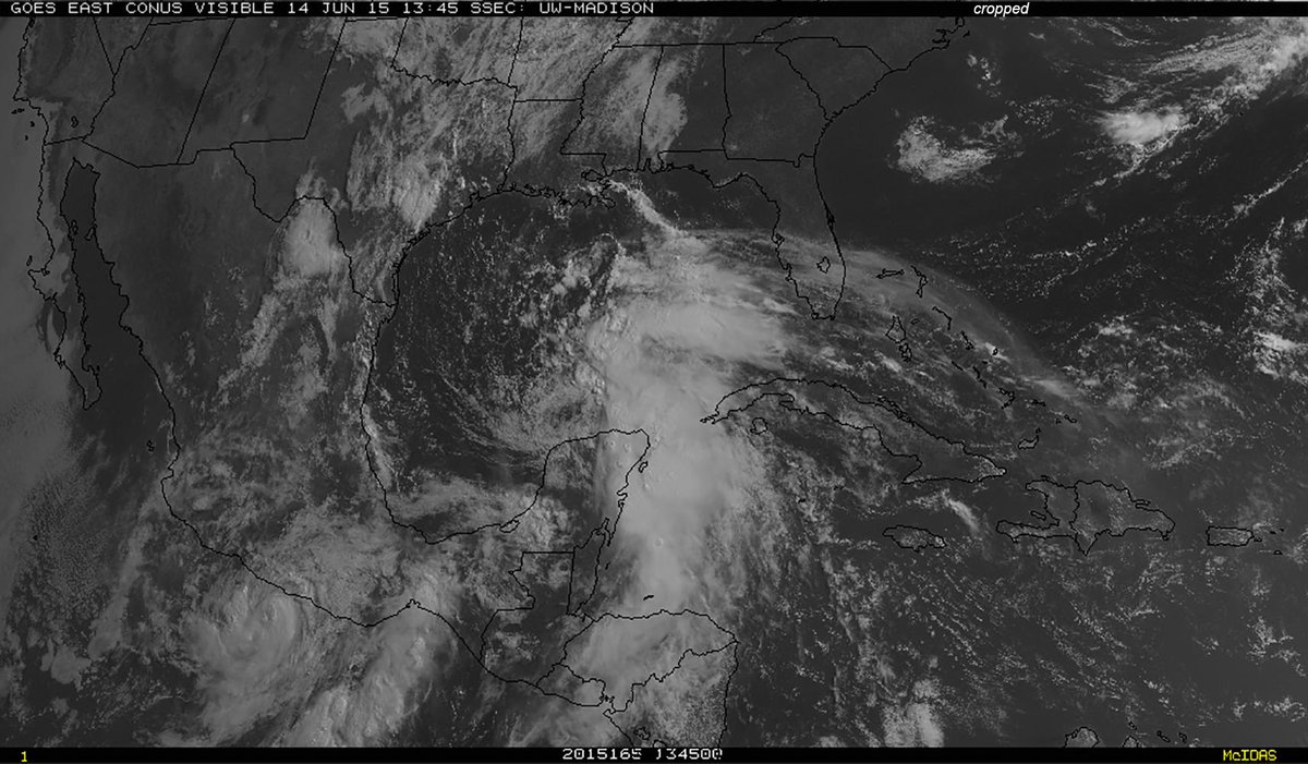
Not many changes with the overnight guidance, still looks like a weak disturbance into Texas.

The big story with this will probably be the heavy rain that will fall to the E of I-35 and over towards the Louisiana border. The Trinity and Red River watersheds are already maxed out and more flooding could be on the way for those areas.

One interesting thing with this is that the PV streamer that seemed to have kicked this whole mess off pinched off an ULL that is now hindering development. Models tend to struggle with the movement of ULL and how they evolve in the presence of heavy convection, so it will be interesting to see how this system develops over the next couple of days. If the ULL moves out of the way and/or weakens then conditions should improve for development as this moves into the NWGOM.

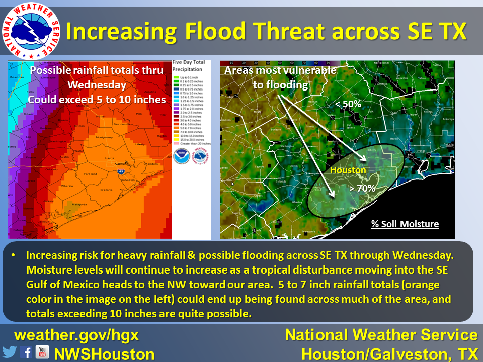
ETA: What the NWS in Houston is thinking this morning
This post was edited on 6/14/15 at 9:33 am
Posted on 6/14/15 at 9:39 am to LSU2001
quote:
Mainly just bumping this back to page one, but the sheared mess exiting the yucatan this morning seems to be trying to form a center a good bit farther north than the current models initialized. If that is indeed the case then South Louisiana needs to be on watch for flooding rains early this week.
It is hard to tell without recon data but the northern Yucatan and out in the Gulf just N of there does have the best combo of mid-level vorticity and lower shear. However, it might not make a huge difference in the eventual track given the modeled strength and position of the ridge.
This post was edited on 6/14/15 at 9:40 am

 Page 11 of 26

Popular
Back to top