- My Forums
- Tiger Rant
- LSU Recruiting
- SEC Rant
- Saints Talk
- Pelicans Talk
- More Sports Board
- Coaching Changes
- Fantasy Sports
- Golf Board
- Soccer Board
- O-T Lounge
- Tech Board
- Home/Garden Board
- Outdoor Board
- Health/Fitness Board
- Movie/TV Board
- Book Board
- Music Board
- Political Talk
- Money Talk
- Fark Board
- Gaming Board
- Travel Board
- Food/Drink Board
- Ticket Exchange
- TD Help Board
Customize My Forums- View All Forums
- Show Left Links
- Topic Sort Options
- Trending Topics
- Recent Topics
- Active Topics
Started By
Message
Hurricane satellite imagery from the 1980’s-1990’s doesn’t have the scary black color
Posted on 10/27/25 at 9:59 am
Posted on 10/27/25 at 9:59 am
At least the ones that I could find.
Why does satellite imagery of hurricanes today include so much black?
Why does satellite imagery of hurricanes today include so much black?
This post was edited on 10/27/25 at 10:04 am
 10
10


Posted on 10/27/25 at 10:00 am to weagle1999
there's a Katrina joke to be made here, i'm just not sure what it is.
Posted on 10/27/25 at 11:07 am to weagle1999
quote:
Why does satellite imagery of hurricanes today include so much black?
DEI

Posted on 10/27/25 at 11:08 am to weagle1999
Thanks for those pics for reference. The detail in them clearly shows what you're talking about. 

Posted on 10/27/25 at 11:10 am to OweO
quote:
DEI
Posted on 10/27/25 at 12:20 pm to weagle1999
The scary black colors on the photos you posted represent

Posted on 10/27/25 at 12:26 pm to weagle1999
What are you blabbering about?
Posted on 10/27/25 at 1:24 pm to weagle1999
Since you are referencing images, don't you think it would have been appropriate to include a couple?
Posted on 10/27/25 at 2:22 pm to weagle1999
If a weather app had a Lootie layer option for hurricanes, I'd pay for it.

Posted on 10/27/25 at 2:26 pm to weagle1999
The colors just help represent cloud top temperatures.
Posted on 10/27/25 at 3:08 pm to Roll Tide Ravens
Thanks. Were they measuring temperatures in recent previous decades?
Posted on 10/27/25 at 4:02 pm to weagle1999
That's an IR image, so yes, they were measuring temperature there. Just with much shitter tech.

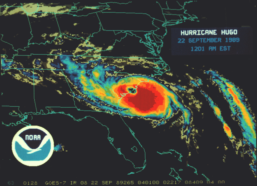
Posted on 10/28/25 at 4:15 am to weagle1999
Hurricane Hugo. I remember not going to school for a month. 135mph winds in Mt Pleasant (Charleston) and a 15’ storm surge. Was absolute hell.
A forgotten beast of the 80s with all of the other more recent storms. Charleston has thankfully bounced back stronger than ever.
Mellissa looks like an absolute monster this morning. The Blue Mountains are going to be Jamaican’s worst enemy here. Up to 60” of rain onto that old loose volcanic soil, which is very very prone to land slides/mudslides.
The eastern side of Jamaica will take a decade or more to recover, if it even does. This will , unfortunately, be a mass casualty event. Hopefully some of our assets in the Gulf will turn off from their show of force and provide some humanitarian aid as per normal in these situations. Looks like the USNS Mercy is in Mobile currently?
Posted on 10/28/25 at 6:41 am to weagle1999
Back in the 1980’s a brand new airplane equipped with the latest radar tech encountered an issue where the radar showed something beyond the color palette as clear. It caused the pilots to believe they were going to a clearing when ultimately it was hail storm and the engines shut off due to water. The radar phenomenon became known as “blacker than black.”
The pilots had to land on a levee in New Orleans east. It was TACA Airlines 110.
The pilots had to land on a levee in New Orleans east. It was TACA Airlines 110.

 Page 1 of 1


Popular
Back to top