- My Forums
- Tiger Rant
- LSU Recruiting
- SEC Rant
- Saints Talk
- Pelicans Talk
- More Sports Board
- Fantasy Sports
- Golf Board
- Soccer Board
- O-T Lounge
- Tech Board
- Home/Garden Board
- Outdoor Board
- Health/Fitness Board
- Movie/TV Board
- Book Board
- Music Board
- Political Talk
- Money Talk
- Fark Board
- Gaming Board
- Travel Board
- Food/Drink Board
- Ticket Exchange
- TD Help Board
Customize My Forums- View All Forums
- Show Left Links
- Topic Sort Options
- Trending Topics
- Recent Topics
- Active Topics
Started By
Message

Derecho Alert: Sunday Afternoon to Evening, NTX, SW OK. MDT extended
Posted on 6/7/25 at 3:10 pm

Posted on 6/7/25 at 3:10 pm

MDT has been added to the map for OK and NTX. Considerable Impacts from destructive wind (80-100 MPH) and embedded Tornadoes are expected tm.
This post was edited on 6/8/25 at 1:22 pm
 13
13

Posted on 6/7/25 at 3:12 pm to 50_Tiger
Those events are brutal, my sympathy for those in the path…
Posted on 6/7/25 at 3:13 pm to 50_Tiger
Been through two serious derecho events in my lifetime here in Memphis (2003, 2017). They are no freaking joke. National media tends to neglect them too.
Posted on 6/7/25 at 3:18 pm to AlonsoWDC
Baton rouge derecho was freaking crazy
Pitch black early in the morning. Twas green skies at daybreak
Pitch black early in the morning. Twas green skies at daybreak
Posted on 6/7/25 at 3:20 pm to 50_Tiger
That derecho that hit downtown Houston a year or so ago was wicked. One of the freakiest things I’ve seen.

Posted on 6/7/25 at 3:25 pm to 50_Tiger
That sucks. That Houston one last year passed right over my house and is why I have a whole house generator now.
Posted on 6/7/25 at 3:49 pm to 50_Tiger
The 2020 Iowa derecho is the standard for these type storms, and is probably the costliest such storm in history.
Lots of wild stuff in this playlist:
Youtube Link
Lots of wild stuff in this playlist:
Youtube Link
This post was edited on 6/7/25 at 3:49 pm
Posted on 6/7/25 at 4:05 pm to billjamin
it ripped open my exterior garage door and then turned my garage door inside out. also blasted my locked french doors wide open and blew down about 40ft of my fence. shite was wild.
Posted on 6/7/25 at 4:37 pm to Klark Kent
When did Derechos start being recognized and given that name?
Before that, what were they called?
Before that, what were they called?
Posted on 6/7/25 at 5:08 pm to real turf fan
quote:
When did Derechos start being recognized and given that name?
Before that, what were they called?
Some people still call them straight line wind storms.

Posted on 6/7/25 at 5:42 pm to 50_Tiger
Ill be in Westlake Sunday night.
Posted on 6/8/25 at 1:17 pm to 50_Tiger
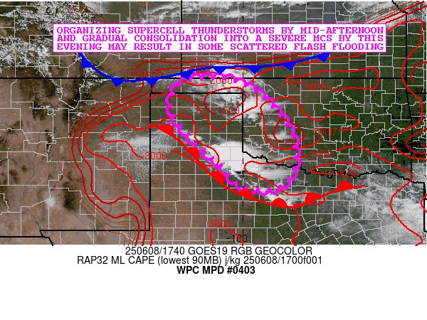
Update:


Obviously this is not going to be fun.
quote:
Day 1 Convective Outlook
NWS Storm Prediction Center Norman OK
1145 AM CDT Sun Jun 08 2025
Valid 081630Z - 091200Z
...THERE IS A MODERATE RISK OF SEVERE THUNDERSTORMS FROM THE EASTERN
TEXAS PANHANDLE INTO SOUTHERN OKLAHOMA AND NORTHWEST/NORTH-CENTRAL
TEXAS...
...THERE IS A SLIGHT RISK OF SEVERE THUNDERSTORMS ACROSS THE
MID-ATLANTIC/SOUTHEAST STATES...
...SUMMARY...
A severe weather outbreak is expected across the southern Plains
today, including southern Oklahoma and much of northwest and North
Texas. A few tornadoes, destructive wind gusts of 80-100 mph, and
giant hail up to 3-5 inches in diameter are likely. Strong wind
gusts, and perhaps a couple of tornadoes, are also possible across
portions of the Mid-Atlantic and Southeast.
...Northwest/North Texas and Oklahoma...
A very active severe-weather day is expected including a regional
outbreak of severe storms. The potential exists for very large hail
and a few tornadoes this afternoon, with widespread damaging
winds/derecho potentially developing into this evening and
overnight, especially across much of North Texas and southern
Oklahoma.
Broad west-northwesterly flow is present today across the
central/southern Plains, with a surface cold front sagging southward
across Kansas. Ahead of the front, a very moist boundary-layer air
mass is in place across much of Oklahoma/Texas, with dewpoints in
the upper 60s and lower 70s. Ample daytime heating and near
dry-adiabatic low/mid-level lapse rates will yield a large reservoir
of extremely high CAPE values across western Oklahoma and northwest
Texas. See Mesoscale Discussion 1196 for additional short-term
details.
Rapid development of intense thunderstorms will ensue by mid/late
afternoon along the cold front over western Oklahoma and along a
complex dryline structure over the eastern Texas Panhandle. Strong
deep layer shear will support intense supercells, despite rather
weak low-level winds. Very large hail, damaging winds, and a few
tornadoes will be possible as these storms track southeastward
across western/central Oklahoma and toward western North Texas,
likely congealing into one or more prominent bowing MCSs.
The risk of widespread destructive winds will increase through the
evening as the potentially prominent linear convective system
organizes/gradually accelerates east-southeastward across southern
Oklahoma and North Texas. At least some lingering damaging
wind/embedded tornado potential may reach as far east-southeast as
the ArkLaTex and ArkLaMiss late tonight.
Obviously this is not going to be fun.

Posted on 6/8/25 at 1:18 pm to LegendInMyMind
I was in Cedar Rapids the fall after that event. shite was wild
Posted on 6/8/25 at 1:20 pm to 50_Tiger
Looks like OKC misses the grand finale. Been a crazy wet spring and stormy too.
Be safe down south/west. Hope its not as bad as predicted
Be safe down south/west. Hope its not as bad as predicted
Posted on 6/8/25 at 1:22 pm to OU Guy
Im assuming its going to root to that warm front. For me and my poor windows its all about the direction 
Posted on 6/8/25 at 1:31 pm to 50_Tiger
One weatherman's take:
oliverek7
@oliverek7
1/ US severe #thunderstorms (06/08) - A dangerous complex of storms will march southeastward across W/S OK and N TX today. Cells will first initiate, likely around 2-3pm, along a weak cold front draped across N OK into the OK panhandle.

2/ In our MDT zone across N TX and S OK, soundings for 7pm (left) and 9pm (right) show a very unstable airmass will be in place. Due to strong surface heating today, drier air will be mixed down to low-levels and dewpoint depressions will become large.


3/ Cloud bases will be high (perhaps >1000m) and storms will be outflow dominant. This reduces the tornado risk despite favourable wind profiles. Embedded tornadoes cannot be ruled out, especially in areas of greater low-level buoyancy and northern edges of bowing segments.
4/ Strong evaporative cooling will enhance downdrafts and produce very strong straight-line surface winds perhaps up to 100mph. Additionally, due to such high CAPE and cloud tops likely reaching 50-60k feet, VERY frequent lightning and large hail will accompany these storms.

5/ Extreme instability will persist ahead of the storm complex well into the night, allowing it to remain organised and maintain intensity as it continues southeastward. N TX/Red river area likely a potential tornado hotspot should any brief spin-ups occur. Dangerous day ahead.
oliverek7
@oliverek7
1/ US severe #thunderstorms (06/08) - A dangerous complex of storms will march southeastward across W/S OK and N TX today. Cells will first initiate, likely around 2-3pm, along a weak cold front draped across N OK into the OK panhandle.
2/ In our MDT zone across N TX and S OK, soundings for 7pm (left) and 9pm (right) show a very unstable airmass will be in place. Due to strong surface heating today, drier air will be mixed down to low-levels and dewpoint depressions will become large.
3/ Cloud bases will be high (perhaps >1000m) and storms will be outflow dominant. This reduces the tornado risk despite favourable wind profiles. Embedded tornadoes cannot be ruled out, especially in areas of greater low-level buoyancy and northern edges of bowing segments.
4/ Strong evaporative cooling will enhance downdrafts and produce very strong straight-line surface winds perhaps up to 100mph. Additionally, due to such high CAPE and cloud tops likely reaching 50-60k feet, VERY frequent lightning and large hail will accompany these storms.
5/ Extreme instability will persist ahead of the storm complex well into the night, allowing it to remain organised and maintain intensity as it continues southeastward. N TX/Red river area likely a potential tornado hotspot should any brief spin-ups occur. Dangerous day ahead.
Posted on 6/8/25 at 1:32 pm to OU Guy
Posted on 6/8/25 at 1:45 pm to 50_Tiger
Fml, I don’t like the shift towards Dallas. Currently a nice day. If it wasn’t for this post, I wouldn’t know we’re about to get rocked.

Posted on 6/8/25 at 1:46 pm to threeputtforbogie
quote:
Currently a nice day. If it wasn’t for this post, I wouldn’t know we’re about to get rocked.
Sounds similar to weather right before a hurricane. Stay safe over there. Already warned a friend in Little Elm area about this, told him to get all his stuff done early today
Posted on 6/8/25 at 1:53 pm to CuseTiger
DFW, especially the west side of the metroplex has been hammered by storm after storm this year.
I’ll be following this from work in Houston tonight for my entire family that lives over that way.
I’ll be following this from work in Houston tonight for my entire family that lives over that way.

 Page 1 of 7

Popular
Back to top