- My Forums
- Tiger Rant
- LSU Recruiting
- SEC Rant
- Saints Talk
- Pelicans Talk
- More Sports Board
- Coaching Changes
- Fantasy Sports
- Golf Board
- Soccer Board
- O-T Lounge
- Tech Board
- Home/Garden Board
- Outdoor Board
- Health/Fitness Board
- Movie/TV Board
- Book Board
- Music Board
- Political Talk
- Money Talk
- Fark Board
- Gaming Board
- Travel Board
- Food/Drink Board
- Ticket Exchange
- TD Help Board
Customize My Forums- View All Forums
- Show Left Links
- Topic Sort Options
- Trending Topics
- Recent Topics
- Active Topics
Started By
Message

Southeast Severe Weather Threat: March 4-5, 2025
Posted on 3/2/25 at 10:34 am

Posted on 3/2/25 at 10:34 am
March 4th (outlook runs through 6 AM CST on March 5):


March 5th:


Regional Radar:

March 5th:
Regional Radar:
This post was edited on 3/4/25 at 9:14 am
 25
25

Posted on 3/2/25 at 12:03 pm to Roll Tide Ravens
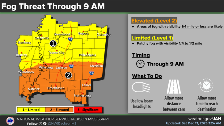
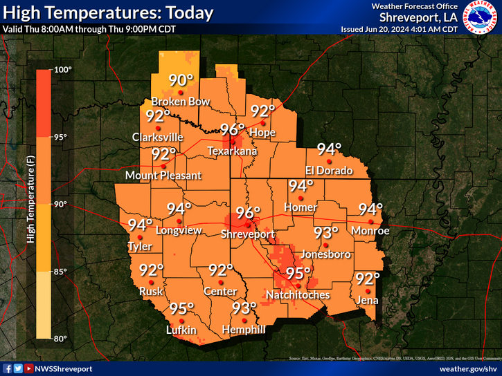
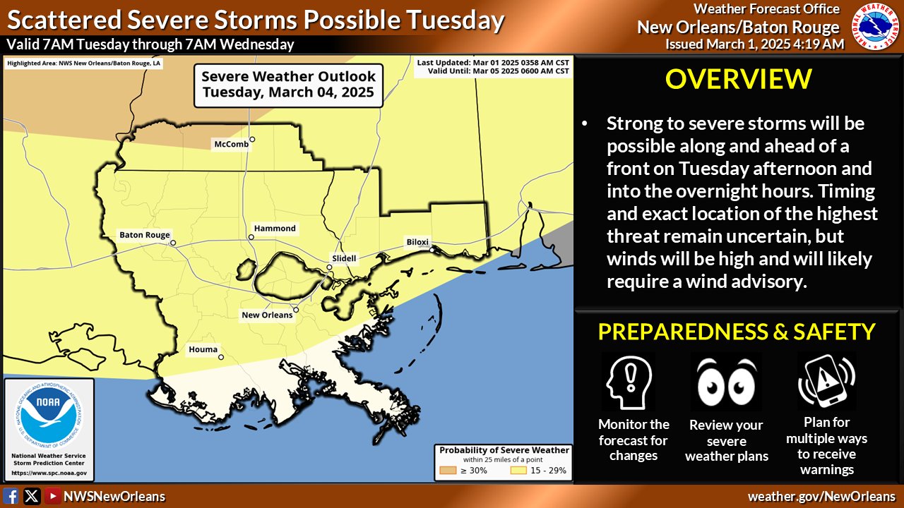
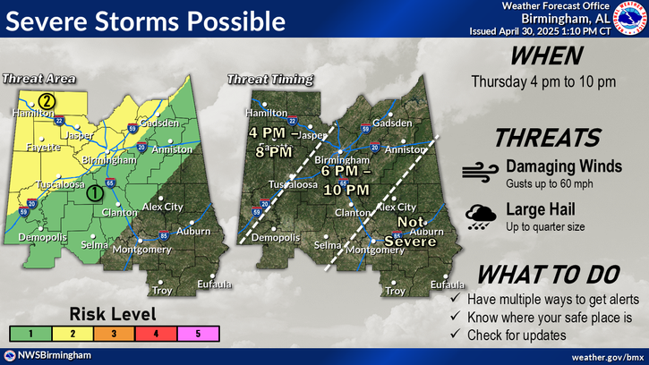
Local NWS office graphics:
NWS Jackson, MS
NWS Shreveport, LA
NWS New Orleans, LA
NWS Birmingham, AL
NWS Jackson, MS
NWS Shreveport, LA
NWS New Orleans, LA
NWS Birmingham, AL

Posted on 3/2/25 at 12:39 pm to Roll Tide Ravens
Looks like it could get ugly….
Posted on 3/2/25 at 12:40 pm to dukke v
Crawfish prices…
Posted on 3/2/25 at 12:41 pm to Roll Tide Ravens
Are we expecting more renegade super cell development with this one at this time?
Reed Timmer may choose to camp out around Monroe (Funroe) or Jackson if I had to guess.
Reed Timmer may choose to camp out around Monroe (Funroe) or Jackson if I had to guess.
Posted on 3/2/25 at 3:03 pm to Roll Tide Ravens
latest from SPC for Tuesday

quote:
Probability of severe weather within 25 miles of a point.
Hatched Area: 10% or greater probability of significant severe weather within 25 miles of a point.
Posted on 3/2/25 at 3:11 pm to Roll Tide Ravens
I put this in the other thread:
quote:
It'll be a good bowling ball trough ejection with a slight negative tilt to it. There's a low pressure system from the west today that will start moisture return for the setup on Tueday. Pretty amplified trough with stout, divergent flow aloft. Warm sector doesn't look that broad, and the northern extent looks to get pinched off a bit, which is probably the reason for the slight westward shift of the Enhanced area in the most recent SPC update. Looks to have pretty strong forcing which could lead to a messier/linear storm mode. We will probably have strong gradient winds well to the east of the advancing front/progressing low throughout the day on Tuesday. Another mostly nocturnal threat for the north MS and AL folks......yay......
This post was edited on 3/2/25 at 3:12 pm

Posted on 3/2/25 at 5:01 pm to LegendInMyMind
I’ll be driving through that.
I am excite
I am excite
Posted on 3/2/25 at 6:42 pm to LegendInMyMind
Don't see a Wind Forecast like this very often "Outside of the Storms"
Fat Tuesday Floats gonna be tricky....30-40 mph Sustained ; up to 60mph gust??
...HIGH WIND WATCH IN EFFECT FROM TUESDAY MORNING THROUGH TUESDAY
EVENING...
* WHAT...South winds 30 to 40 mph with gusts up to 60 mph possible.
* WHERE...Portions of southeast Louisiana and southern Mississippi.
* WHEN...From Tuesday morning through Tuesday evening.
* IMPACTS...High profile vehicles, including Mardi Gras floats,
could become unstable at times. Damaging winds could blow down
trees and power lines. Isolated to scattered power outages are
possible. Travel could be difficult, especially for high profile
vehicles.
PRECAUTIONARY/PREPAREDNESS ACTIONS...
Monitor the latest forecasts and warnings for updates.
Posted on 3/2/25 at 7:00 pm to RBTiger
As long as the Rex ball has backup generators.
Posted on 3/2/25 at 7:00 pm to Roll Tide Ravens
So sick of this shite week after week.
Posted on 3/2/25 at 7:08 pm to Roll Tide Ravens
Gonna put a downer on New Roads parades.

Posted on 3/2/25 at 8:03 pm to Twincam
quote:
So sick of this shite week after week.
Then move.

Posted on 3/2/25 at 8:44 pm to Twincam
quote:
So sick of this shite week after week.
Ok so move to the west coast where you have earthquakes, 9 months of great weather but absolutely horrid conditions the rest of the year, complete with flooding rains, and wildfires.
Or the east coast where you have multiple winter storms a year, hot summers, and the occasional hurricane.
Or the north, where you have miserable winters, severe storms in the summer and spring, and can still get hot summers.
Or the plains, where you dodge F3-F5 tornadoes on an annual basis, miserable winters, and miserable summers.
Or you can stay in the south where you’re accustomed to the heat and humidity, you het great winters outside of a few weeks, amazing springs outside of a weekly severe threat that rarely materializes on a localized scale, and annual hurricane threats where the hurricane isn’t really that bad unless you’re on the immediate coastline or in the direct path of a major (which is rare).
Quit being a pussy and just be mindful of the weather on Tuesday like a man and take action if something threatens you.
Posted on 3/2/25 at 8:46 pm to dukke v
quote:
Looks like it could get ugly….
quote:
dukke v
I can breathe a sigh of relief.

Posted on 3/3/25 at 12:26 am to Shorts Guy
quote:
Gonna put a downer on New Roads parades.
I’ve seen them run those parades in a snow storm. Gonna have to be really bad for them to shut down.
They might start earlier though.
Posted on 3/3/25 at 1:42 am to Roll Tide Ravens
I'll be in Memphis yet again for this one....my timing is impeccable
Posted on 3/3/25 at 12:05 pm to Roll Tide Ravens
Looks like enhanced risk moved closer to Northshore and southern Mississippi.
I bet at least one of Bassfield, Monticello, Brookhaven, Tylertown, Sumrall, and Columbia will see something as usual. There is something about the air there that is not a fluke.
I bet at least one of Bassfield, Monticello, Brookhaven, Tylertown, Sumrall, and Columbia will see something as usual. There is something about the air there that is not a fluke.

Posted on 3/3/25 at 12:31 pm to TDsngumbo
quote:
and annual hurricane threats where the hurricane isn’t really that bad unless you’re on the immediate coastline or in the direct path of a major (which is rare).
Not to derail this thread but when do the "experts" start making their prognostications for the 2025 hurricane season?
I am just wondering what HTS should plan for. We depleted our food stockpile last year during Helene.
I AM NOT WISHCASTING FOR ANY HURRICANES but just trying to plan.
We do still have enough for a 3-4 day trip somewhere if a bad tornado hits a populated area and has wide spread power outage. During those 4 days we can do about 4,000 meals.
On a separate note we have had someone who wants to buy us a second mobile kitchen, and we hare getting an estimate from a company that specializes in these type trailers. This second unit would be used after a hurricane and they would setup 30-50 miles from the main unit and be serviced by the same refrigerated truck we have. It would double the number of meals we could provide, from around 8,000 for a week to maybe up to 15,000.
Posted on 3/3/25 at 12:36 pm to Paul Allen
quote:
Then move.
How about your dumbass move and disconnect your internet?

 Page 1 of 9

Popular
Back to top