- My Forums
- Tiger Rant
- LSU Recruiting
- SEC Rant
- Saints Talk
- Pelicans Talk
- More Sports Board
- Fantasy Sports
- Golf Board
- Soccer Board
- O-T Lounge
- Tech Board
- Home/Garden Board
- Outdoor Board
- Health/Fitness Board
- Movie/TV Board
- Book Board
- Music Board
- Political Talk
- Money Talk
- Fark Board
- Gaming Board
- Travel Board
- Food/Drink Board
- Ticket Exchange
- TD Help Board
Customize My Forums- View All Forums
- Show Left Links
- Topic Sort Options
- Trending Topics
- Recent Topics
- Active Topics
Started By
Message
What is the highest point in Louisiana south of I-10?
Posted on 1/30/25 at 9:19 am
Posted on 1/30/25 at 9:19 am
Is it Avery Island or another salt dome?
Update:
I was looking for natural elevation.
Looks like Avery Island wins with a highest elevation of 163 feet.
Honorable mention to Lafayette, which rises up to nearly ~60 feet in some areas.
Update:
I was looking for natural elevation.
Looks like Avery Island wins with a highest elevation of 163 feet.
Honorable mention to Lafayette, which rises up to nearly ~60 feet in some areas.
This post was edited on 1/30/25 at 3:18 pm
 11
11


Posted on 1/30/25 at 9:25 am to Hobie101
Probably a landfill somewhere.
Posted on 1/30/25 at 9:42 am to Hobie101
The capital
Posted on 1/30/25 at 9:58 am to LSUballs
quote:
The capital
Pretty sure the State Capitol is north of I-10 by a couple hundred yards...

Posted on 1/30/25 at 9:58 am to Hobie101
I would say the gyp stack at Mosaic Uncle Sam... 

Posted on 1/30/25 at 10:01 am to Hobie101
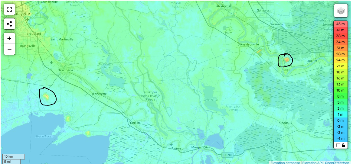
It appears to be in the area of Avery Island looking on a Topo map. There is also an area in the general area northwest of Lutcher near Convent that is close. This is a totally unscientific opinion.
Avery Island area
Convent Area
In the Pic you can see the red spots. The slightly darker red at Avery Island is 2 or 3 meters higher.
Avery Island area
Convent Area
In the Pic you can see the red spots. The slightly darker red at Avery Island is 2 or 3 meters higher.
This post was edited on 1/30/25 at 10:11 am
Posted on 1/30/25 at 10:07 am to Hobie101
I do not know the answer to this.
That said, the state capitol is known to be taller than the highest landmass (mountain or hill) in the state. Obv. both the capitol and hills are north of 10, so that doesn't help.
That said, the state capitol is known to be taller than the highest landmass (mountain or hill) in the state. Obv. both the capitol and hills are north of 10, so that doesn't help.
Posted on 1/30/25 at 10:11 am to RichJ
quote:
Pretty sure the State Capitol is north of I-10 by a couple hundred yards...

Posted on 1/30/25 at 10:26 am to mdomingue
quote:
Convent Area
This is very Louisiana. Some of the highest points are piles of industrial waste.
Posted on 1/30/25 at 10:43 am to Hobie101
Monkey Hill at the Audubon Zoo

Posted on 1/30/25 at 11:19 am to Hobie101
The top of Boudreaux's Bass Pro Hat
It's 5' 4" from ground level
It's 5' 4" from ground level
Posted on 1/30/25 at 11:25 am to Hobie101
Looking at a topo map, it looks like most of the east side of Lafayette is high ground.
The Superdome and a few areas in the New Orleans original "crescent" area are also red on the topo map.

The Superdome and a few areas in the New Orleans original "crescent" area are also red on the topo map.
This post was edited on 1/30/25 at 11:55 am
Posted on 1/30/25 at 1:37 pm to Hobie101
Indian Mounds

Posted on 1/30/25 at 2:14 pm to mdomingue
The Mosaic stack... 
Posted on 1/30/25 at 2:15 pm to Hobie101
one shell square
Posted on 1/30/25 at 6:50 pm to Hobie101
Landfill by welsh?

 Page 1 of 1


Popular
Back to top