- My Forums
- Tiger Rant
- LSU Recruiting
- SEC Rant
- Saints Talk
- Pelicans Talk
- More Sports Board
- Fantasy Sports
- Golf Board
- Soccer Board
- O-T Lounge
- Tech Board
- Home/Garden Board
- Outdoor Board
- Health/Fitness Board
- Movie/TV Board
- Book Board
- Music Board
- Political Talk
- Money Talk
- Fark Board
- Gaming Board
- Travel Board
- Food/Drink Board
- Ticket Exchange
- TD Help Board
Customize My Forums- View All Forums
- Show Left Links
- Topic Sort Options
- Trending Topics
- Recent Topics
- Active Topics
Started By
Message
re: Severe Weather Rolls On: May 7-10, 2024
Posted on 5/8/24 at 1:19 pm to 50_Tiger
Posted on 5/8/24 at 1:19 pm to 50_Tiger
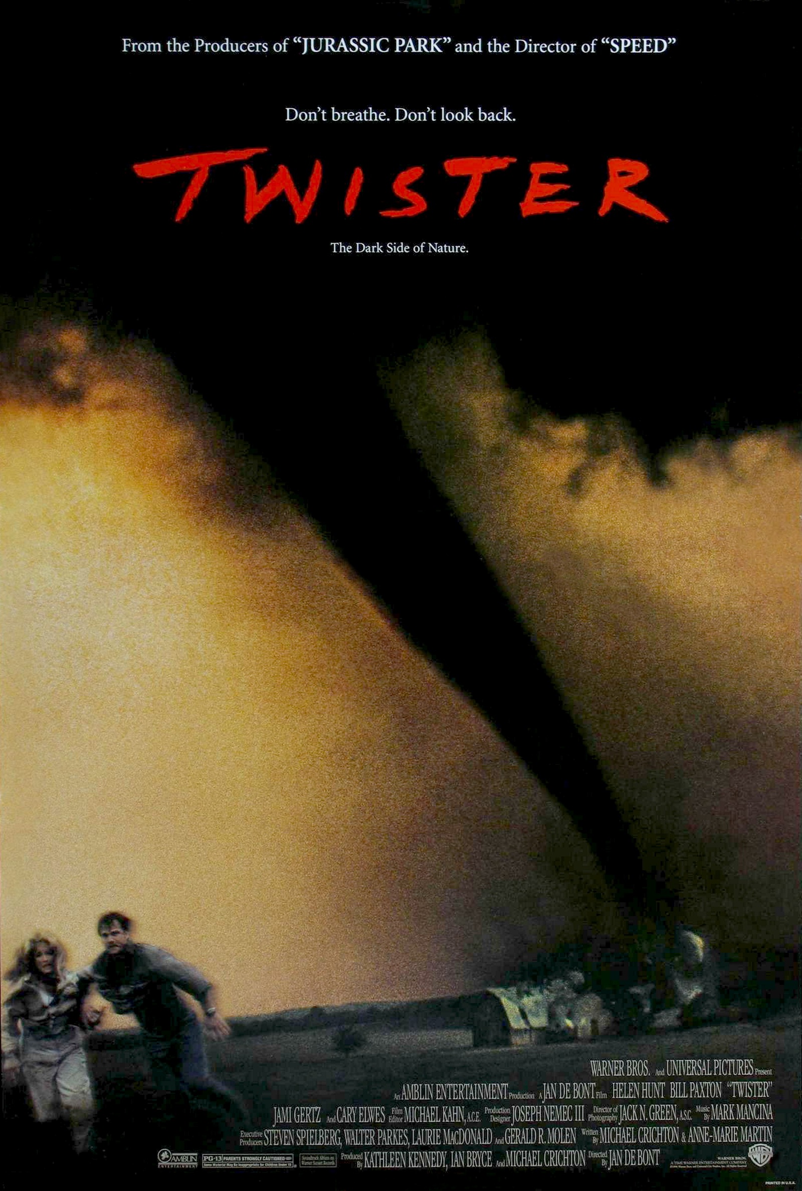
This opens July 19th, to me they shoulda had it ready for peak tornado season
Loading Twitter/X Embed...
If tweet fails to load, click here. 3
3


Posted on 5/8/24 at 1:27 pm to OU Guy
Tornado Warning NE of me. Not any strong rotation at the moment. Symsonia, Calvert City, Reidland
Posted on 5/8/24 at 1:29 pm to OU Guy
quote:
This opens July 19th, to me they shoulda had it ready for peak tornado season
I have an existential crises brewing over this movie.

Posted on 5/8/24 at 1:33 pm to LegendInMyMind
quote:
I have an existential crises brewing over this movie.
I’m ready for the science in the movie to be terrible. Worse than the original Twister.
That said, I’ll go and see it.
Posted on 5/8/24 at 1:35 pm to LegendInMyMind
quote:
I have an existential crises brewing over this movie.
Its entertainment there will be 1,000 things wrong in it. But movies are to entertain so have to view it that way. Basically, one has to turn their brain off while watching
Posted on 5/8/24 at 1:38 pm to OU Guy
quote:
This opens July 19th, to me they shoulda had it ready for peak tornado season
Why are they using the Friends font?

Posted on 5/8/24 at 1:53 pm to 50_Tiger
looks like the sunbelt conference picked a good day to start the conference track meet in monroe. 
Posted on 5/8/24 at 1:54 pm to Roll Tide Ravens
I’m surprised this storm south of St. Louis doesn’t have a tornado warning on it yet.

Posted on 5/8/24 at 1:54 pm to Bestbank Tiger
quote:reed is there for youuuuu (clap clap clap clap clap)
Why are they using the Friends font?
Posted on 5/8/24 at 1:55 pm to Bestbank Tiger
quote:
Why are they using the Friends font?
Same font as the original Twister.
Posted on 5/8/24 at 1:57 pm to Roll Tide Ravens
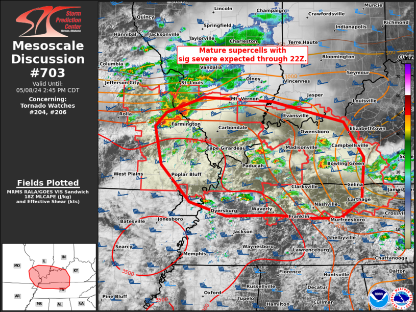
Mesoscale Discussion 0703
NWS Storm Prediction Center Norman OK
0150 PM CDT Wed May 08 2024
Areas affected...parts of the Mid-MS...Lower OH...and TN Valleys
Concerning...Tornado Watch 204...206...
Valid 081850Z - 081945Z
The severe weather threat for Tornado Watch 204, 206 continues.
SUMMARY...Very large hail, isolated severe wind gusts, and tornadoes
will remain probable with mature supercells across parts of the
Mid-Mississippi to Lower Ohio and Tennessee Valleys through the rest
of the afternoon.
DISCUSSION...Several supercells are ongoing with two distinct
regimes. An intense, long-track supercell in cluster regime persists
across a part of the Mid-MS Valley, between STL and CGI. Numerous
large hail up to baseball size have been reported during the past
hour. This supercell cluster should continue to evolve east along
the tight instability gradient across southern IL, with potential
for further upscale growth along its southwest flank. Damaging winds
of 70-80 mph, along with attempts at occasional tornadogenesis will
remain possible.
Farther southeast, more discrete supercells continue to
increase/mature. Low-level SRH is relatively greater across
south-central KY into northern Middle TN near/northeast of the
residual outflow from the morning MCS. Low-level flow has become
veered to the southwest per time-series of PAH VWP data, tempering
warm-sector hodograph enlargement. Overall, a mix of all severe
hazards, some of which may be significant, is anticipated in/near
both tornado watches through 22Z.
..Grams.. 05/08/2024
Posted on 5/8/24 at 1:57 pm to Roll Tide Ravens
quote:
I’m surprised this storm south of St. Louis doesn’t have a tornado warning on it yet.
Tornado warning for it now.
Posted on 5/8/24 at 1:58 pm to Roll Tide Ravens
"dont breathe. dont look back"
what is this a quiet place? were tornados aware of sound back then?
what is this a quiet place? were tornados aware of sound back then?
Posted on 5/8/24 at 2:09 pm to Pedro
Reed Timmer and Dominator Crew Live Chasing in KY/TN
Brandon Copic Live Chasing in Illinois
Brandon Copic Live Chasing in Illinois
This post was edited on 5/8/24 at 2:18 pm
Posted on 5/8/24 at 2:15 pm to Pedro
For the central Alabama folks. Two of round event for us. One overnight tonight into the early afternoon tomorrow. Another round tomorrow night into the early Friday morning.
Loading Twitter/X Embed...
If tweet fails to load, click here.This post was edited on 5/8/24 at 2:18 pm
Posted on 5/8/24 at 2:18 pm to OU Guy
quote:
Its entertainment there will be 1,000 things wrong in it. But movies are to entertain so have to view it that way. Basically, one has to turn their brain off while watching
That's not it. You just don't dick with a classic.
Posted on 5/8/24 at 2:21 pm to LegendInMyMind
Western North Carolina has some of the worst radar coverage in the country.
Posted on 5/8/24 at 2:22 pm to Roll Tide Ravens

Posted on 5/8/24 at 2:26 pm to Roll Tide Ravens
quote:
Western North Carolina has some of the worst radar coverage in the country.
All the mountains.
Posted on 5/8/24 at 2:50 pm to Roll Tide Ravens
NWS Nashville missed that tornado.
This post was edited on 5/8/24 at 2:56 pm

 Page 7 of 36

Back to top