- My Forums
- Tiger Rant
- LSU Recruiting
- SEC Rant
- Saints Talk
- Pelicans Talk
- More Sports Board
- Fantasy Sports
- Golf Board
- Soccer Board
- O-T Lounge
- Tech Board
- Home/Garden Board
- Outdoor Board
- Health/Fitness Board
- Movie/TV Board
- Book Board
- Music Board
- Political Talk
- Money Talk
- Fark Board
- Gaming Board
- Travel Board
- Food/Drink Board
- Ticket Exchange
- TD Help Board
Customize My Forums- View All Forums
- Show Left Links
- Topic Sort Options
- Trending Topics
- Recent Topics
- Active Topics
Started By
Message
Severe Weather Thread 6/18
Posted on 6/18/23 at 7:43 pm
Posted on 6/18/23 at 7:43 pm
Mostly a wind threat for most of MS and to a lesser degree south southwestern TN. Some hail threat too

Little surprised they already dropped this
Little surprised they already dropped this
This post was edited on 6/18/23 at 7:44 pm
 6
6

Posted on 6/18/23 at 7:45 pm to Wishnitwas1998
This pattern we are stuck in is crazy.
Here in Hammond area, the yard is dead from lack of rain.
The deer camp in Brookhaven has been hammered all week
Here in Hammond area, the yard is dead from lack of rain.
The deer camp in Brookhaven has been hammered all week
Posted on 6/18/23 at 7:46 pm to CypressTrout10
It has been odd but I think we are mostly coming out of it after today
Posted on 6/18/23 at 7:46 pm to Wishnitwas1998
Might as well change to Daily Severe Weather thread, now we have a damn possible hurricane brewing too
Posted on 6/18/23 at 8:02 pm to TutHillTiger
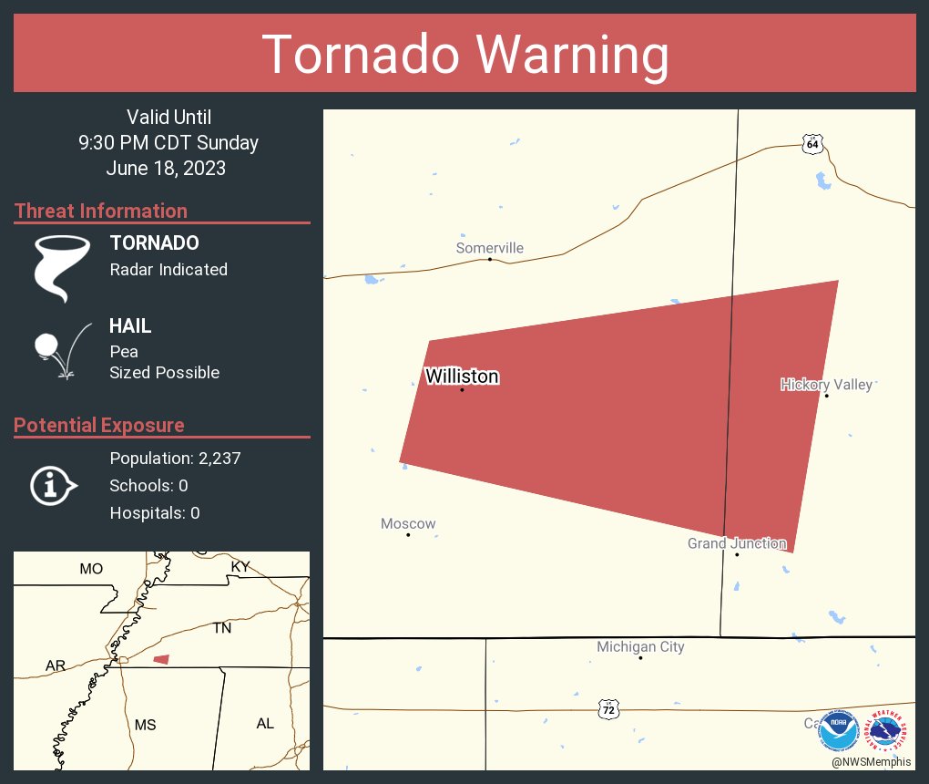
Tornado warning NE of Jackson, MS

This post was edited on 6/18/23 at 8:04 pm

Posted on 6/18/23 at 8:08 pm to Wishnitwas1998
quote:
It has been odd but I think we are mostly coming out of it after today
Yep, but we will have an upper low meandering around the southeast most of this coming week which will mean elevated rain chances for a lot of us through the week. Shouldn’t see nearly as much severe weather, though.
Posted on 6/18/23 at 8:14 pm to Roll Tide Ravens
Debris signature on radar between Morton, MS and Forest, MS.
Posted on 6/18/23 at 8:21 pm to Wishnitwas1998
SPC has just introduced a 10% tornado risk with a hatched area for much of central MS into west-central AL for tonight into the early AM.

...THERE IS AN ENHANCED RISK OF SEVERE THUNDERSTORMS ACROSS THE
LOWER MISSISSIPPI VALLEY/SOUTHEAST...
...SUMMARY...
Severe thunderstorms capable of large hail, damaging winds, a few
tornadoes will remain possible tonight across the Lower Mississippi
Valley and Southeast.
...Lower Mississippi Valley/Southeast States...
Severe thunderstorm potential will continue tonight with early
evening observed soundings continuing to sample seasonally strong
westerlies aloft and steep mid-level lapse rates. The most focused
tornado risk, including the potential for a strong tornado, appears
to be semi-focused across central/northern Mississippi, and perhaps
into western Alabama as air mass recovery and warm/moist advection
continues to occur. This scenario is highlighted by the 00z observed
sounding from Jackson MS with featured nearly 4000 J/kg MLCAPE, 45
kt effective shear, 200+ 0-1 km SRH and 400+ 0-3km SRH. Additional
strengthening of 1-3 km AGL winds is likely through
mid/late-evening, which should further heighten the tornado risk.
This post was edited on 6/18/23 at 8:23 pm
Posted on 6/18/23 at 8:30 pm to Roll Tide Ravens
No bueno

Posted on 6/18/23 at 8:32 pm to Wishnitwas1998
Raining hard as hell in Memphis area.
I’m digging it though.
I’m digging it though.
Posted on 6/18/23 at 8:37 pm to CypressTrout10
quote:
This pattern we are stuck in is crazy.
The setup tonight is highly unusual for this time of year. Already several Tornado warnings across this watch box.

Posted on 6/18/23 at 8:38 pm to Wishnitwas1998
We’re finally getting some rain here. Much needed for the flowers and crops. I hope it continues to pour. The Mississippi up near Cape Girardeau is extremely low.
Posted on 6/18/23 at 8:42 pm to Pisco
Confirmed tornado just NE of Brandon, MS.
Posted on 6/18/23 at 8:45 pm to Roll Tide Ravens


Posted on 6/18/23 at 8:49 pm to Roll Tide Ravens
I hate how I can’t read any of that shite
Posted on 6/18/23 at 8:58 pm to SabiDojo
New tornado or severe thunderstorm watch (probably tornado watch) coming soon for much of the western half of Alabama.

This post was edited on 6/18/23 at 8:58 pm
Posted on 6/18/23 at 9:10 pm to Roll Tide Ravens
Well, shite.....they just clipped me.
Posted on 6/18/23 at 9:12 pm to Roll Tide Ravens
This one a ways a way but headed more to my area

Posted on 6/18/23 at 9:15 pm to LegendInMyMind
Textbook April time supercell producing a tornado south of Jackson

Posted on 6/18/23 at 9:18 pm to The Boat


 Page 1 of 7

Popular
Back to top