- My Forums
- Tiger Rant
- LSU Recruiting
- SEC Rant
- Saints Talk
- Pelicans Talk
- More Sports Board
- Fantasy Sports
- Golf Board
- Soccer Board
- O-T Lounge
- Tech Board
- Home/Garden Board
- Outdoor Board
- Health/Fitness Board
- Movie/TV Board
- Book Board
- Music Board
- Political Talk
- Money Talk
- Fark Board
- Gaming Board
- Travel Board
- Food/Drink Board
- Ticket Exchange
- TD Help Board
Customize My Forums- View All Forums
- Show Left Links
- Topic Sort Options
- Trending Topics
- Recent Topics
- Active Topics
Started By
Message

Try your own hand at gerrymandering
Posted on 1/24/22 at 3:34 pm
Posted on 1/24/22 at 3:34 pm
Districtr
SIAP, but I thought this was neat as we move into the final stages of the redistricting process. The above link allows you to choose a state and then re-draw its congressional districts as you see fit at the voting precinct level. It also gives you the population parameters and several different sets of data to work with. For most states, you can also view past election data to analyze the districts you draw.
Though it is a little late now, in states like Michigan you could submit your own district ideas to the state committee for re-districting.
 5
5


Posted on 1/24/22 at 3:59 pm to Indefatigable
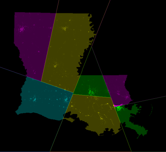
I'd like to see Louisiana do something like this. Tried to make the populations as close as possible. They are within 5% of each other so they'd need to be adjusted a bit. The smallest district was the top one with Shreveport but only by about 4%.

This post was edited on 1/24/22 at 3:59 pm
Posted on 1/24/22 at 4:03 pm to Mickey Goldmill
Anything to get rid of the geographical abomination we have now is an improvement in my book. My map for LA looked pretty similar to yours.
This post was edited on 1/24/22 at 4:15 pm
Posted on 1/24/22 at 4:08 pm to Mickey Goldmill
blue section is 90% water and no land, so are you counting the fish?
Posted on 1/24/22 at 4:11 pm to keakar
quote:
blue section is 90% water and no land, so are you counting the fish?
Um, did you not see NOLA in the blue section?
Posted on 1/24/22 at 4:11 pm to keakar
quote:
blue section is 90% water and no land, so are you counting the fish?
Counting population which includes Nola. That district has almost the exact same amount of people as the rest of them.
Posted on 1/24/22 at 4:15 pm to Mickey Goldmill
How did you post the image? When I try on the site it only copies as a link, not an img.
Posted on 1/24/22 at 4:18 pm to Indefatigable
quote:
How did you post the image? When I try on the site it only copies as a link, not an img.
It did the same for me. I had to screenshot it and upload it to imgbb.com to post it here.
Posted on 1/24/22 at 4:25 pm to Mickey Goldmill
Thanks.
ETA: Well nvm, I tried that and couldn't make it work.
ETA: Well nvm, I tried that and couldn't make it work.
This post was edited on 1/24/22 at 4:27 pm
Posted on 1/24/22 at 4:27 pm to Mickey Goldmill
That wouldn’t make sense. The districts are too concise. They aren’t skinny enough. You don’t have any districts with both BR and NO included. It’s as if some simpleton did it. Someone in a hurry who didn’t consider making it look weird.
Posted on 1/24/22 at 4:32 pm to doubleb
quote:
That wouldn’t make sense. The districts are too concise. They aren’t skinny enough. You don’t have any districts with both BR and NO included. It’s as if some simpleton did it. Someone in a hurry who didn’t consider making it look weird.

Posted on 1/24/22 at 4:38 pm to Indefatigable
I like letting the math do it.
Splitline Algorithm
Louisiana would look like this:
Here is another computer algorithm
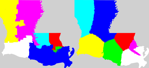
Splitline Algorithm
Louisiana would look like this:
Here is another computer algorithm
This post was edited on 1/24/22 at 4:42 pm
Posted on 1/24/22 at 4:43 pm to TrueTiger
That is a good starting point in reining in the ridiculous shapes, IMO. However I am not sure straight lines like that will ever work in practice. When considering that these districts are first and foremost for Congressional representation, I think there needs to be (and most state laws require that there are) considerations for existing political and geographical boundaries in addition to ensuring that the districts are geographically contiguous.
Posted on 1/24/22 at 4:46 pm to TrueTiger
quote:
I like letting the math do it.
Splitline Algorithm
Louisiana would look like this:
That's not much different than mine. Yours just split north Louisiana vertically rather than horizontally like mine did.
The cool thing with the OPs site is it will break down the partisan split with whatever map you make. Mine would result in the same seat allocations as we have now. 1 Dem - 5 GOP.
Posted on 1/24/22 at 4:51 pm to Mickey Goldmill
Those are from math guys that make algorithms that carve up the population and area with zero regard to politics, race, income, gender, nationality, etc.
It's all math, none of that comes into play.
Now it would probably mean no more AOC types but on the other side it would probably mean no more MTG types either.

Posted on 1/24/22 at 4:58 pm to keakar
quote:
blue section is 90% water and no land, so are you counting the fish?
As the fish tend to vote Democrat, it was appropriate to group them with New Orleans.

Posted on 1/24/22 at 4:59 pm to Indefatigable
Everything by county-line other than Jefferson. I did not split Birmingham City

Remember that in the South, we gerrymander FOR the Democrats


Remember that in the South, we gerrymander FOR the Democrats
Posted on 1/24/22 at 5:04 pm to TrueTiger
quote:
Those are from math guys that make algorithms that carve up the population and area with zero regard to politics, race, income, gender, nationality, etc.
It's all math, none of that comes into play.
Now it would probably mean no more AOC types but on the other side it would probably mean no more MTG types either.
Oh I get that. I didn't do mine with regards to that either. Purely on making the populations equal to each other and trying to keep big cities within a single district. It just happened to turn out with the same political seats as what we have now (meaning we could potentially do something like this and nobody in power should complain).
Posted on 1/24/22 at 5:09 pm to TrueTiger
quote:
Those are from math guys that make algorithms
So, racists.
Posted on 1/24/22 at 5:19 pm to Indefatigable
I've been obsessed with this site for the past few days. Glad somebody else is sharing in my obsession. I've made an 11-3 GA, an all red LA, a TX with only 7 Dem seats, and an all red AL (similar to somebody else's above) among other maps that would all get struck down by some left wing court.
This post was edited on 1/24/22 at 5:21 pm

 Page 1 of 2

Popular
Back to top