- My Forums
- Tiger Rant
- LSU Recruiting
- SEC Rant
- Saints Talk
- Pelicans Talk
- More Sports Board
- Fantasy Sports
- Golf Board
- Soccer Board
- O-T Lounge
- Tech Board
- Home/Garden Board
- Outdoor Board
- Health/Fitness Board
- Movie/TV Board
- Book Board
- Music Board
- Political Talk
- Money Talk
- Fark Board
- Gaming Board
- Travel Board
- Food/Drink Board
- Ticket Exchange
- TD Help Board
Customize My Forums- View All Forums
- Show Left Links
- Topic Sort Options
- Trending Topics
- Recent Topics
- Active Topics
Started By
Message


 1
1


Posted on 4/22/19 at 1:09 pm to VoxDawg
I just checked google earth 3D and the date of the same exact pic I posted above from google earth; is Feb. 2017
Posted on 4/22/19 at 1:10 pm to VoxDawg
So what's going on underground on that island?
(Funny thing I was just there last summer taking the ferry out of Red Hook to St. John. The XO Bistro is a pretty good place to eat right across the ferry...would recommend.)
(Funny thing I was just there last summer taking the ferry out of Red Hook to St. John. The XO Bistro is a pretty good place to eat right across the ferry...would recommend.)
Posted on 4/22/19 at 1:12 pm to VoxDawg
on google maps the tennis court appears to be on a hill in 3D it is strange. but the date is Feb 2017 on google earth with the same views. it is very strange and his weird arse clock sun dial thing is seen and very strange.
Posted on 4/22/19 at 1:15 pm to jmcwhrter
Google Earth is using old elevation data with new photography. That's why the tennis court looks all hilly.
I'm sure they graded the top of that hill down to build a flat tennis court.
I'm sure they graded the top of that hill down to build a flat tennis court.
Posted on 4/22/19 at 1:16 pm to cajunangelle
No one's saying the Google Earth images are current.
I don't know when the drone pics were taken, but it seems that that might be able to be divined before too long. Expert analysis indicates that it was likely within the last few weeks. If I get more from those who know more than me about the origin dates of the drone pics, I'll certainly share.
I don't know when the drone pics were taken, but it seems that that might be able to be divined before too long. Expert analysis indicates that it was likely within the last few weeks. If I get more from those who know more than me about the origin dates of the drone pics, I'll certainly share.

Posted on 4/22/19 at 1:17 pm to VoxDawg
You forgot pre tennis court

Posted on 4/22/19 at 1:18 pm to GumboPot
quote:
I'm sure they graded the top of that hill down to build a flat tennis court.
**ASSUMING** that the photos have been taken via drone within the last (I'm going to pick an arbitrary time frame) 4 weeks, as posited by Aerial PhotographyAnon, where is the tennis court in those presumably April 2019 photos?
Posted on 4/22/19 at 1:24 pm to VoxDawg
So the Google Earth imagery is older than the drone image in the OP, but the tennis court is missing in the new drone imagery.
Am I interpreting that correct?
ETA: and the vegetation is so dead around the diked area in the OP. Weird.
Am I interpreting that correct?
ETA: and the vegetation is so dead around the diked area in the OP. Weird.
This post was edited on 4/22/19 at 1:27 pm
Posted on 4/22/19 at 1:33 pm to VoxDawg
Looks like a shithole.

Posted on 4/22/19 at 1:37 pm to cajunangelle
quote:
it is very strange and his weird arse clock sun dial thing is seen and very strange.
The real action is underground...
Posted on 4/22/19 at 1:37 pm to VoxDawg
Okay. According to Google Earth images it looks like the tennis court was receiving no maintenance after Hurricane Maria.
Before Maria:
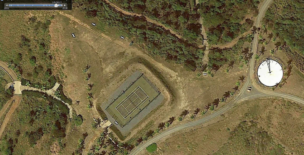
After Maria:
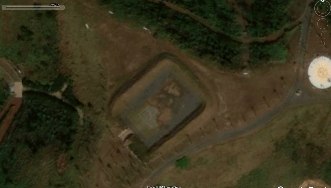
Latest Google Earth image:
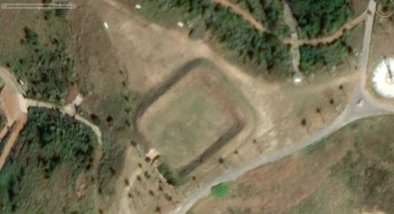
Which appears to match the image in the OP.
Before Maria:
After Maria:
Latest Google Earth image:
Which appears to match the image in the OP.
Posted on 4/22/19 at 1:47 pm to GumboPot
Gumbo, where are you finding the timeline function in the top left of your Maria pic?
Posted on 4/22/19 at 1:49 pm to ThinePreparedAni
quote:
The real action is underground...

Posted on 4/22/19 at 1:51 pm to VoxDawg
Could the bermed arena be a helicopter landing space? The berm to keep the dirt/dust from spreading out?
Posted on 4/22/19 at 1:54 pm to GumboPot

This photo comes up on the island listing for Google Maps, with an April 2018 date, but that might be because it's when it was uploaded.
It's obviously of the "tennis court" area when it was under construction. Or it's 2 dozen bodies buried. Who knows?
Posted on 4/22/19 at 1:55 pm to GumboPot
quote:
So what's going on underground on that island?
I can’t imagine very much. Looking at the the surrounding terrain, it can’t go anywhere unless it goes straight down and would take a massive operation to dig out.
I’m guessing it’s a small storage bunker or something. Maybe he’s a prepper.
This post was edited on 4/22/19 at 1:57 pm
Posted on 4/22/19 at 1:59 pm to RonLaFlamme
quote:
Could the bermed arena be a helicopter landing space? The berm to keep the dirt/dust from spreading out?
Under normal circumstances, I'd agree, but there's this area that seems designated for helipad use:

Posted on 4/22/19 at 2:01 pm to VoxDawg
I can't find the bermed arena on google maps, but according to the pics, it is near the blue roofed building, which roughly lines up with the area labeled H(elipad). Maybe dated pictures/imagery?
This post was edited on 4/22/19 at 2:02 pm

Posted on 4/22/19 at 2:02 pm to AaronDeTiger
quote:
Looks like a shithole.
The snorkeling at Christmas Cove on the North side is fantastic. Viability is great and biodiversity is awesome. You can also order a pizza from your boat. Not quite a shithole. The island's owner is another story.

 Page 2 of 6

Popular
Back to top