- My Forums
- Tiger Rant
- LSU Recruiting
- SEC Rant
- Saints Talk
- Pelicans Talk
- More Sports Board
- Coaching Changes
- Fantasy Sports
- Golf Board
- Soccer Board
- O-T Lounge
- Tech Board
- Home/Garden Board
- Outdoor Board
- Health/Fitness Board
- Movie/TV Board
- Book Board
- Music Board
- Political Talk
- Money Talk
- Fark Board
- Gaming Board
- Travel Board
- Food/Drink Board
- Ticket Exchange
- TD Help Board
Customize My Forums- View All Forums
- Show Left Links
- Topic Sort Options
- Trending Topics
- Recent Topics
- Active Topics
Started By
Message
re: IS "SATELLITE RECEPTION" *really* the basis for Internet, TV, and "Global Communications"?
Posted on 2/11/22 at 11:28 am to NYNolaguy1
Posted on 2/11/22 at 11:28 am to NYNolaguy1
quote:
Whoever thinks we have satellites floating overhead will be in for a rude awakening when they hit the dome over our flat earth.
You either DO know exactly what's going on, OR...
Step out.
 1
1

Posted on 2/11/22 at 11:29 am to Liberator
quote:
ALL of them dust off the lies & deception we're all misdirected to and lead straight to truth.
Is part of the truth that the earth is flat?
Posted on 2/11/22 at 11:46 am to mouton
quote:yeah this dumbass is a flat earther or a fed.
s part of the truth that the earth is flat?
Posted on 2/11/22 at 11:55 am to LookSquirrel
To ALL interested in the limits of sight on this Realm / Ball / Whatever:
Mind-Blowing.
LINK ]What do you see? Is it CURVED Earth? OR, FLAT?
NOTE: This video is taken by an Engineer from the window of a Florida to DFW Flight (Infrared Lens ZOOM camera) by JTolan Media1 (Check out this guy's other amazing videos)
QUESTION: From the West Coast of Florida, how is Cape Canaveral, North Carolina, and hundreds of further miles able to be seen OVER the "curvature"?
Flight Perspective: Florida to Dallas-Fort Worth Flight -- and yes, some vid is taken of the Gulf coast. (Again -- and not a trick-question; what do your own eyes see? CURVED or FLAT?)
Camera: 950 nm INFRARED-ZOOM. I assure you -- none of you have ever seen the earth from THIS perspective. The Infrared Zoom Lens allows permeability through the atmospheric haze to extend views of the earth impossible otherwise.
The distances seen should NOT be possible were we to "believe The Science".
Posted on 2/11/22 at 12:02 pm to mouton
The video speaks for itself.
What do you see? CURVED Earth? OR, FLAT? We see looooong distances that should not be able to be seen over the "Curvature" of Earth.
Florida via Infrared-ZOOM
What do you see? CURVED Earth? OR, FLAT? We see looooong distances that should not be able to be seen over the "Curvature" of Earth.
Florida via Infrared-ZOOM
Posted on 2/11/22 at 12:06 pm to narddogg81
quote:
quote:
(Is part of the truth that the earth is flat?)
yeah this dumbass is a flat earther or a fed.
Nice ATTEMPT at twisting Mouton's question
Please stay away from sharp objects and keep on wearing that safety helmet, Troll.
This post was edited on 2/11/22 at 12:07 pm
Posted on 2/11/22 at 12:22 pm to Liberator
Tell you what. Do your own experiment.
Buy a really nice telescope. Say, somewhere between 1000-3000 dollars. Go to NYC and go to the top of a skyscraper like the freedom tower.
Get the coordinates for Western Sahara. No mountains in the way or anything like that.
Can you see Western Sahara with your telescope? Let us know.
Buy a really nice telescope. Say, somewhere between 1000-3000 dollars. Go to NYC and go to the top of a skyscraper like the freedom tower.
Get the coordinates for Western Sahara. No mountains in the way or anything like that.
Can you see Western Sahara with your telescope? Let us know.
Posted on 2/11/22 at 12:28 pm to Liberator
quote:dear god this is retarded
The video speaks for itself.
What do you see? CURVED Earth? OR, FLAT? We see looooong distances that should not be able to be seen over the "Curvature" of Earth.
Florida via Infrared-ZOOM

Posted on 2/11/22 at 12:32 pm to Fun Bunch

and since I'm here... Liberator, a lot of posters are requesting your return on the young earth thread.
This post was edited on 2/11/22 at 12:39 pm
Posted on 2/11/22 at 12:33 pm to Fun Bunch
quote:better yet, just take a boat ride out onto the ocean with some binoculars and watch the other ships drop below the horizon within about 4 miles distance
Tell you what. Do your own experiment.
Buy a really nice telescope. Say, somewhere between 1000-3000 dollars. Go to NYC and go to the top of a skyscraper like the freedom tower.
Get the coordinates for Western Sahara. No mountains in the way or anything like that.
Can you see Western Sahara with your telescope? Let us know.

Posted on 2/11/22 at 1:43 pm to Liberator
quote:
Whoever thinks we have satellites floating overhead will be in for a rude awakening when they hit the dome over our flat earth.
quote:I know the main engineer designer of the first spy satellite. This is funny.
You either DO know exactly what's going on, OR...
Step out.
quote:
To ALL interested in the limits of sight on this Realm / Ball / Whatever:
Mind-Blowing.
What do you see? Is it CURVED Earth? OR, FLAT?
NOTE: This video is taken by an Engineer from the window of a Florida to DFW Flight (Infrared Lens ZOOM camera) by JTolan Media1 (Check out this guy's other amazing videos)
QUESTION: From the West Coast of Florida, how is Cape Canaveral, North Carolina, and hundreds of further miles able to be seen OVER the "curvature"?
Flight Perspective: Florida to Dallas-Fort Worth Flight -- and yes, some vid is taken of the Gulf coast. (Again -- and not a trick-question; what do your own eyes see? CURVED or FLAT?)
Camera: 950 nm INFRARED-ZOOM. I assure you -- none of you have ever seen the earth from THIS perspective. The Infrared Zoom Lens allows permeability through the atmospheric haze to extend views of the earth impossible otherwise.
The distances seen should NOT be possible were we to "believe The Science".
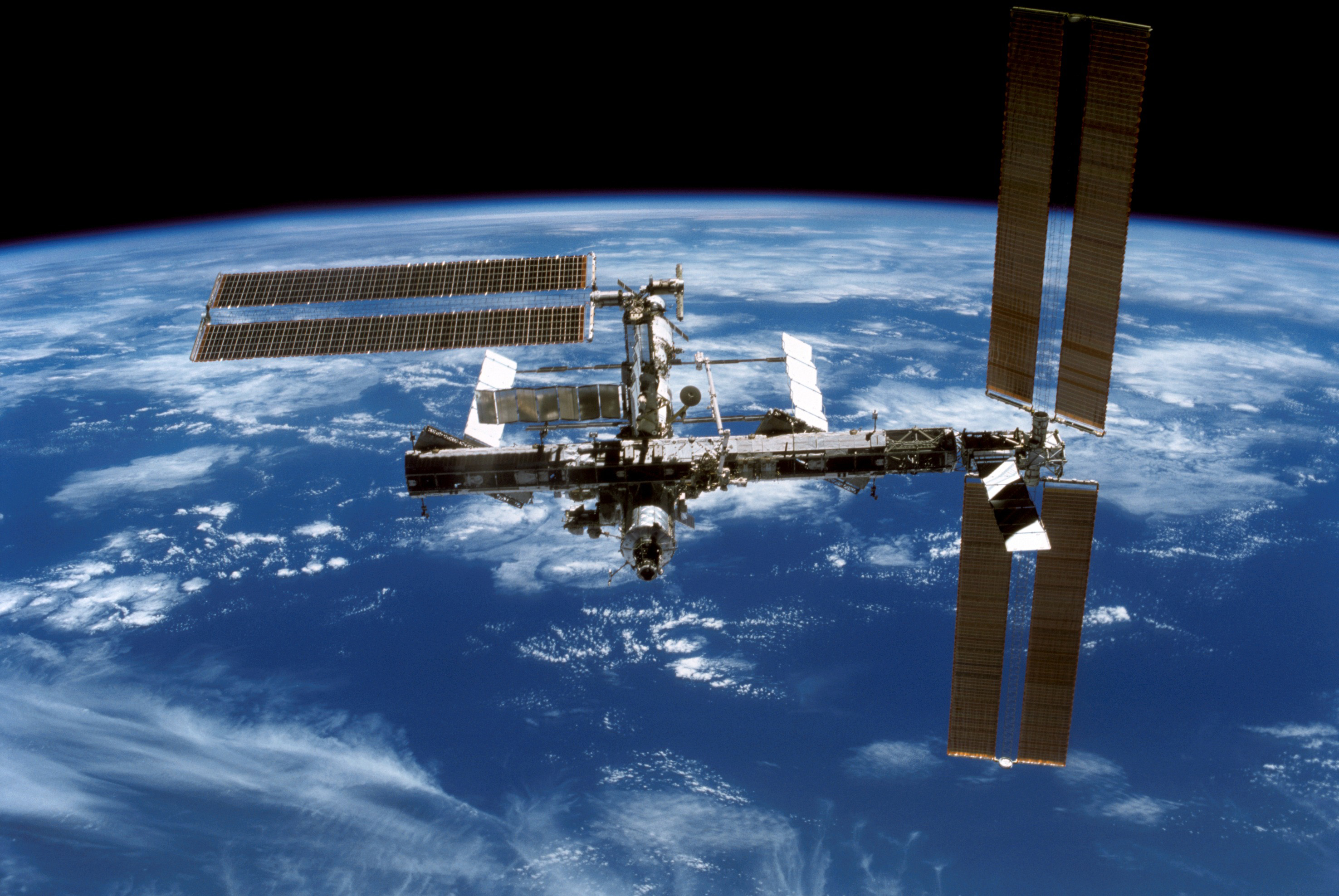
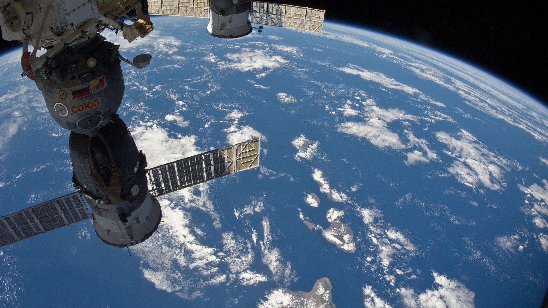
Look through this photo album of pics from the international space station. START WITH THE VIDEO IN THIS LINK
Start with the video to prove they are where they are then look at all of the proof the earth simply is not flat.
Famous Earthrise photo from Apollo 8
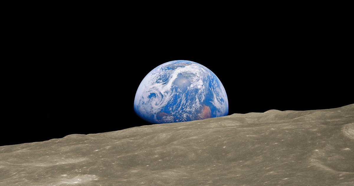
So many photos from the ISS prove earth is not flat.
I also saw a write-up that basically explains: the plane that guy was filming in was at the wrong altitude to view earths curvature.
Sorry but I don't find your subject interesting because it is so easily proven from the ISS that the earth is not flat. So it is a waste of time in debate.
And please don't Sheila Jax Lee out on me and say the ISS photos are fake.
There are a lot of other things to talk about. Pick another subject.
This post was edited on 2/11/22 at 1:48 pm
Posted on 2/11/22 at 1:49 pm to Liberator
quote:i wasted some of my life watching this piece of shite video. at no point anywhere in that video can you see more than about 200 miles. you can look at the plane's flight path and the features on the ground to see exactly where this douche is at during each shot. he doesnt see to fricking north carolina, he says some clouds in the distance are over the grand banks, while hes looking in a direction that is not north carolina. He offers no evidence thats where the clouds are. And even if they were clouds over NC, that doesnt mean the earth is flat. clouds are thousands of feet in the air. this dudes at 28000 feet. The horizon is determined by the elevation of the observer, the elevation/height of the object being observer, and the curve of the earth.
To ALL interested in the limits of sight on this Realm / Ball / Whatever:
Mind-Blowing.
What do you see? Is it CURVED Earth? OR, FLAT?
NOTE: This video is taken by an Engineer from the window of a Florida to DFW Flight (Infrared Lens ZOOM camera) by JTolan Media1 (Check out this guy's other amazing videos)
QUESTION: From the West Coast of Florida, how is Cape Canaveral, North Carolina, and hundreds of further miles able to be seen OVER the "curvature"?
Flight Perspective: Florida to Dallas-Fort Worth Flight -- and yes, some vid is taken of the Gulf coast. (Again -- and not a trick-question; what do your own eyes see? CURVED or FLAT?)
Camera: 950 nm INFRARED-ZOOM. I assure you -- none of you have ever seen the earth from THIS perspective. The Infrared Zoom Lens allows permeability through the atmospheric haze to extend views of the earth impossible otherwise.
The distances seen should NOT be possible were we to "believe The Science".
When hes out over the gulf hes looking back across Cedar Key. From the flight path you can tell the east coast of florida is about 186 miles from the location along the flight path where Cedar Key would be at that angle in the video (due south of Tallahasee). hes at 28000 feet, which means the horizon is 205 miles, which lines up exactly with what's shown in the video, east coast of florida visible and about 20 miles of the atlantic.. you are a fricking gullible moron or a troll.
Posted on 2/11/22 at 2:05 pm to Liberator
quote:
And I doubt you can name a legit "reason".
Imaging…
Posted on 2/11/22 at 2:17 pm to Liberator
quote:
Wiseguy -- your thoughts?:
Has anyone tried to claim that NASA, NOAA, amd other agencies use balloons? Just because they use balloons in LOE doesn’t mean they don’t also use rockets to get satellites to space. The two are not mutually exclusive and it takes a small mind to not be able to think about both as being true.
As for the conclusion drawn from the video? Laughable. How does the fact that someone uses a balloon to launch a satellite into LOE support the lunacy of a flat earth?
Posted on 2/11/22 at 2:28 pm to Wiseguy
quote:
How does the fact that someone uses a balloon to launch a satellite into LOE support the lunacy of a flat earth?
I don’t think balloons can be used to put anything into orbit, BUT balloons are used all the damn time to get instrumentation into the upper atmosphere.
Your point still stands, just because balloons exist doesn’t mean that satellites and rockets don’t exist.
This message brought to you by Rockefeller & Soros Cabal Cooperative, LLC.
Posted on 2/14/22 at 10:14 am to Wiseguy
quote:
Has anyone tried to claim that NASA, NOAA, amd other agencies use balloons?
Just because they use balloons in LOE doesn’t mean they don’t also use rockets to get satellites to space. The two are not mutually exclusive...
Yes, they ARE "mutually exclusive". The Truth and EVIDENCE proves otherwise and is laid bare here. I'm only the messanger.
TO ALL:
Whomever watches this video -- and your mind is STILL not changed afterward -- NOTHING will change your mind.
"Space" Satellites Myth Busted Cold
THE VIDEO ABOVE clearly demonstrates how "Satelloons" are used to cover NASA's tracks and illusion that "Space satellites" are functional as they claim.
Simple Question TO ALL:
IF there are THOUSANDS of "satellites" in orbit above us, WHY DO WE NEED BALLOONS TO TRANSMIT INTERNET "CONNECTIONS" TO PEOPLE IN REMOTE AREAS??
The Obvious:
NASA (who receives $52m PER DAY) is coincidentally THE LARGEST consumer of Helium IN THE WORLD. Now, you know WHY.
More truth:
If one watches the paths of all rockets as NASA shoots them up in the sky, they ALL eventually arc...then start dropping, falling out of camera sight beyond the horizon -- only to CRASH in the ocean) completely out of sight. The debris of rocket "carcass is then retrieved with no one the wiser (except those who onto yet one more govt $$$ charade.)
Posted on 2/14/22 at 10:20 am to FutureMikeVIII
NASA "Satellites" BUSTED. They are NOTHING BUT BALLOONS; "Rocket Launched Satellites" NOT NECESSARY.
Moreover, there is no such thing as "Orbiting". Connect the dots.
I realize this is another heartbreaking revelation of how tPTB & govt have lied to us, but blame "science" and NASA ($52m per day) for the litany of charades.
Moreover, there is no such thing as "Orbiting". Connect the dots.
I realize this is another heartbreaking revelation of how tPTB & govt have lied to us, but blame "science" and NASA ($52m per day) for the litany of charades.

Posted on 2/14/22 at 10:28 am to Liberator
quote:
there is no such thing as "Orbiting".
the Jews created gravity
Posted on 2/14/22 at 10:30 am to narddogg81
quote:
i wasted some of my life watching this piece of shite video. at no point anywhere in that video can you see more than about 200 miles. you can look at the plane's flight path and the features on the ground to see exactly where this douche is at during each shot. he doesnt see to fricking north carolina, he says some clouds in the distance are over the grand banks, while hes looking in a direction that is not north carolina. He offers no evidence thats where the clouds are. And even if they were clouds over NC..
Sure. It IS a waste IF you don't watch an entire video AND can't understand what you're watching to BEGIN WITH.
HOW do I know you didn't watch the ENTIRE vid?; because the Engineer / Videographer calculated AND explained distances using common "scientific" formulas.
quote:
hes at 28000 feet, which means the horizon is 205 miles, which lines up exactly with what's shown in the video, east coast of florida visible and about 20 miles of the atlantic..
It's 205 across the State of Florida. You claim ONLY 20 miles further?? smh. You're beyond ignorant AND clueless. There are HUNDREDS of miles into the Atlantic BEYOND the East Coast video shot. Again -- you did NOT watch the whole vid; the videographer is an ENGINEER who knows, explained AND demonstrated how distance was calculated.
I can't help your lack of necessary IQ points and ADD problem. :-(
Posted on 2/14/22 at 10:45 am to cajunangelle
IF you or others are more interested in Truth rather than supporting the deceptions & lies of the same exact Usual Suspects who are already proven to be "Liars" about everything, you've got to leave their Paradigm of Lies plantation of mind-control. THAT necessarily and especially includes NASA.
All of us MUST ask ourselves -- ESPECIALLY in the year 2022:
Of ALL the govt agencies and associative apparatus are already lying to us, why would JUST NASA be the one and only "true, honest, and on-the-level" agency??
ITMT, I promise the photoshopped images you've submitted shall ALL be refuted. EASILY. (btw, who is taking all these "Space Satellite" photos?)
Regarding the (in)famous single 'Earthrise' photo? I'm sorry. It is a bad fraud. This is already proven to be an embarrassing cut & pasted image by citizen forensic photographers and researchers who've merely & simply adjusted the contrast of the original "photo" to reveal a sloppy cut & paste that was never re-edited.

 Page 8 of 11

Popular
Back to top