




- My Forums
- Tiger Rant
- LSU Recruiting
- SEC Rant
- Saints Talk
- Pelicans Talk
- More Sports Board
- Fantasy Sports
- Golf Board
- Soccer Board
- O-T Lounge
- Tech Board
- Home/Garden Board
- Outdoor Board
- Health/Fitness Board
- Movie/TV Board
- Book Board
- Music Board
- Political Talk
- Money Talk
- Fark Board
- Gaming Board
- Travel Board
- Food/Drink Board
- Ticket Exchange
- TD Help Board
Customize My Forums- View All Forums
- Show Left Links
- Topic Sort Options
- Trending Topics
- Recent Topics
- Active Topics
Started By
Message

 0
0


Posted on 4/20/18 at 7:11 am to LaBR4
If we're using flooplain maps to define "land" then the entire middle section of the USA all the way Noth to Minnesota, west to Montana, and east to West Virginia should be erased form the maps

Posted on 4/20/18 at 7:38 am to LaBR4
St. Tammany will be shocked to hear that all those pine forests aren't really there.


Posted on 4/20/18 at 7:44 am to LaBR4



Posted on 4/20/18 at 7:54 am to LaBR4
Apparently "land" = "bedrock"


Posted on 4/20/18 at 7:57 am to LaBR4
So does water erase state lines?

Posted on 4/20/18 at 8:23 am to LaBR4
Political maps show the states jurisdiction of land. That looks like a political depiction of Louisiana.

Posted on 4/20/18 at 8:28 am to cssamerican


Posted on 4/20/18 at 8:29 am to LaBR4
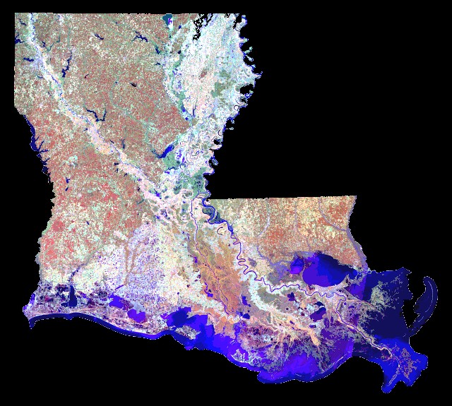
Satellites say differently

Posted on 4/20/18 at 8:29 am to LaBR4
they tryn'a wash us awayyyyy. they tryn'a wash us awaaaaaayyyy!

Posted on 4/20/18 at 8:39 am to LaBR4
That map is extremely racist and as a white male I am offended.


Posted on 4/20/18 at 8:52 am to Oilfieldbiology
It's not "fake" it's just including all wetlands and watersheds as waterways.
There is land in the white areas, but no liveable land.
We had this discussion two years ago when first posted.
There is land in the white areas, but no liveable land.
We had this discussion two years ago when first posted.


Posted on 4/20/18 at 8:55 am to LaBR4
Yea, that map isn’t accurate. Not even a little bit.
Posted on 4/20/18 at 9:51 am to Cosmo
Any of you baws commute from Grand Isle to Buras?
Has to be frustrating, it's only a few miles away, but yet it's 169 miles away.


Has to be frustrating, it's only a few miles away, but yet it's 169 miles away.
This post was edited on 4/20/18 at 9:52 am

Posted on 4/20/18 at 10:14 am to LaBR4

I made an approximate overlay of both maps? And I'm supposed to believe that the second map is accurate? There are entire towns where water is shown on the doctored map. Fake
This post was edited on 4/20/18 at 10:15 am

Posted on 4/20/18 at 10:19 am to Revelator
Your maps aren't aligned.
Posted on 4/20/18 at 10:25 am to MaHittaMaHitta
Anybody live off Bay Coon Road?


I'm guessing you have one of those infinity pools

I'm guessing you have one of those infinity pools
This post was edited on 4/20/18 at 10:28 am
Posted on 4/20/18 at 10:35 am to MaHittaMaHitta
quote:
Your maps aren't aligned.
It's close enough to know that the second map is a complete joke. Look, the erosion problem is real, but making up fake maps to bolster the cause is foolish.
Posted on 4/20/18 at 10:38 am to Revelator
quote:
I made an approximate overlay of both maps? And I'm supposed to believe that the second map is accurate? There are entire towns where water is shown on the doctored map. Fake

not even close

Posted on 4/20/18 at 10:41 am to LaBR4
Texas is stealing our land to the west

 Page 2 of 3

Popular
Back to top
 Follow TigerDroppings for LSU Football News