- My Forums
- Tiger Rant
- LSU Recruiting
- SEC Rant
- Saints Talk
- Pelicans Talk
- More Sports Board
- Fantasy Sports
- Golf Board
- Soccer Board
- O-T Lounge
- Tech Board
- Home/Garden Board
- Outdoor Board
- Health/Fitness Board
- Movie/TV Board
- Book Board
- Music Board
- Political Talk
- Money Talk
- Fark Board
- Gaming Board
- Travel Board
- Food/Drink Board
- Ticket Exchange
- TD Help Board
Customize My Forums- View All Forums
- Show Left Links
- Topic Sort Options
- Trending Topics
- Recent Topics
- Active Topics
Started By
Message
re: What would have prevented the amount of Flood Disaster loss of life?
Posted on 7/11/25 at 9:34 am to AGGIES
Posted on 7/11/25 at 9:34 am to AGGIES
these camps with hundreds of children should have dedicated person up around the clock monitoring weather and the river. no excuse for that. They should be in contact with a contact in the county along with a contact at NWS. even if a few camps pooled resources and were covered by one person...
 1
1

Posted on 7/11/25 at 10:37 am to HeadCall
quote:This until someone comes up with a better idea.
Nothing. shite happens. I don’t want to live in a world where we prevent every tragedy but have zero fun.
Although the body count varies this isn't something new to us. The news cycle changed but the flooding in the east hasn't. Not many bodies lost so no one notices.
Right here in 2016 the weather service did not predict the amount of rain in East B.R. Our terrain is different so the water rose slower and not as devastating. It went up 2' at my house in a very few hours.
Earlier that year (2016) heavy rain in S'port area caused flooding in S.W. La. & S.E. Tx.
Seems like it is just life (and death). Tough world.
Posted on 7/11/25 at 10:49 am to bluedragon
quote:
What warning? BS
This has a west problem for ages. Estes Park 1976 144 dead
Two Park rangers lost their lives.
Whenever we camped anywhere, we look to stay out of dry river beds.
There are no horns. Radios are a waste.
What warnings?
With that attitude, sir......you will very likely wind up in a very bad position one day.
This post was edited on 7/11/25 at 10:50 am
Posted on 7/11/25 at 11:15 am to RanchoLaPuerto
quote:
. It wouldn’t have taken long to move those kids up the hill.
4-6 minutes depending on which cabin they were in.
Posted on 7/11/25 at 11:22 am to diat150
quote:
these camps with hundreds of children should have dedicated person up around the clock monitoring weather and the river. no excuse for that.
Who says they didn't? Feels like a lot of us are coming to conclusions with incomplete information, and just need to wait for all of the facts to come out.
From what I've read, Camp Mystic was monitoring and began evacuation / emergency procedures at around 2 AM and started with the most at risk cabins (historically) and worked way through the others, but the rapid rise of the river was something that was unprecedented and the flood waters got to cabins that had never flooded before they could get the girls out.
In this instance, how much more time would a siren monitoring system have provided for the camp?
Whether or not camps and recreational activities should be allowed in the area is another argument. I'm not sure many people want to live in a world where we try to legislate life in an attempt to achieve 100% safety from everything.
Posted on 7/11/25 at 11:26 am to LegendInMyMind
quote:
4-6 minutes depending on which cabin they were in.
Maybe in perfect conditions in the middle of the day.
Not sure if 4 to 6 minutes is a realistic number when trying to wake 7-10 year old kids from a deep sleep in the middle of the night in bad weather.

Posted on 7/11/25 at 11:28 am to AGGIES
quote:
What would have prevented the amount of Flood Disaster loss of life?
building on higher land.

Posted on 7/11/25 at 11:34 am to Mr Sausage
I didn't make em sign waivers. I'm would assume the rv parks don't accept blame for this either.

Posted on 7/11/25 at 11:45 am to TimeOutdoors
quote:
It’s going to be hard to keep me from believing the rise of 27 feet in 45 mins isn’t because of the amount of debris that was lodged between the piers of the bridge.
No doubt that can create issues in flooding events. That wasn’t the case here. Places didn’t flood because of pooling from drainage problems downstream, or the rivers spilled over their banks to bypass impediments.
A river tsunami overwhelmed anything and everything in its path.
Llano River on Friday afternoon;
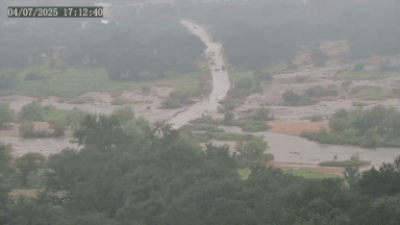
That bridge, and any possible debris it collected, isn’t impeding the flow at all. The bridge is swallowed by the river.

Posted on 7/11/25 at 11:45 am to Nado Jenkins83
I am ignorant of the RV Park process and have no clue what you sign to park there. I do know the RV Parks along the river are extremely close and a number of them took a big hit.
Posted on 7/11/25 at 11:46 am to AGGIES
It’s a pattern
Natural disaster happens
People place blame and say we must do better
Experts are brought in and plans are created
Those plans are expensive and will result in loss of property rights through forced buyouts and relocation
Taxpayers don’t want to pay the prices for such a system, and people don’t want to be forced to relocate for such a rare disaster
30-40 years pass
Natural disaster happens…
Posted on 7/11/25 at 11:49 am to Ghost of Colby
that stretch of the Guadalupe would seem to be well served by elevated loud sirens activated from a 24 hour per day manned source.
not rocket science , not terribly expensive, not new tech.
not rocket science , not terribly expensive, not new tech.
Posted on 7/11/25 at 11:52 am to AGGIES
quote:A drought.
What would have prevented the amount of Flood Disaster loss of life?
Posted on 7/11/25 at 11:52 am to NoMercy
quote:
I think the forecast may have been enough.
It took a bit to come together, as far as the exact location, but they ultimately nailed nearly every aspect of what would happen by the 7:00PM MPD issued by the Weather Prediction Center.
quote:
DISCUSSION...
The remnant mid-level circulation associated with Barry (also classified as an MCV on the graphic) is over western Texas and slowly approaching the Texas Hill Country this evening. Barry's remnant circulation has an abundance of atmospheric moisture at its disposal with PWs ranging anywhere from 2.2-2.5". ECMWF ENS percentiles show these PWs above the 99th climatological percentile, as are the mean specific humidity (g/kg) values at both the 850mb and 500mb height levels. The atmosphere is also quite unstable with MUCAPE generally between 2,000-3,000 J/kg. As night falls, the low-level jet (LLJ) will gradually accelerate out of South Texas and intersect the Hill Country in a manner that supports topographically-forced ascent. This low-level jet is also part of a fairly strong southerly IVT for early July as the ECMWF ENS percentiles depict >500 kg/m/s values (above the 97.5 climatological percentile) over the Hill Country between 00-06Z. The impressive moisture advection is making for some remarkably saturated RAP soundings where low-mid level RH values are >90% and warm cloud layers are 15,000ft deep in many cases.
The concern with the MCV and remnant 500-700mb trough is that it is paired with a persistent LLJ that looks to be steadfast over the region well into the overnight hours. While there is not a ton of vertical wind shear, noticeable veering in the sfc-3km layer ensues as the LLJ strengthens this evening (SErly sfc winds, SWrly 3km winds). This could provide cells with the ability to be somewhat self-sustaining and organized this evening. The other concern is for outflows associated with a growing cold pool from northerly convection to propagate south and be oriented in a way where the southerly LLJ intersects the outflows in a perpendicular fashion. The atmospheric parameters are supportive of not just the potential for >3"/hr maximum rainfall rates, but for back-building and training thunderstorms over the Hill Country.
The I-35 corridor on west is most at-risk for flash flooding tonight. 1-hr FFGs are generally between 1.5-2.0" in portions of the Hill Country, which given the prolific rainfall potential these storms may contain, would have little problem causing flash flooding. For areas where back-building and training storms do occur, locally considerable flash flooding this evening is possible.
Now, that's not a normal, public-facing forecast product that your average person would look at. It is, though, a very important discussion that would have been covered heavily between WPC and the NWS Austin/San Antonio office. Keep in mind that the Flash Flood Watch was issued at 2:35PM, four hours prior to this MPD, and was not set to expire until 7:00AM the following morning. Another, more dire MPD, would be issued at 1:26AM.
Posted on 7/11/25 at 12:00 pm to Mr Sausage
I know. I've stayed at em. The buffalo river in Arkansas we like to go to the erbie site because it's away from crowds. But also no cell service so you ain't getting an alert.
Posted on 7/11/25 at 12:06 pm to Ghost of Colby
quote:
That bridge, and any possible debris it collected, isn’t impeding the flow at all. The bridge is swallowed by the river.
The debris flow would have caused problems in the drastic river bend areas and in runoff channels leading to the river. Thanks to the extended drought conditions in that area there was plenty of debris (even without pieces of homes, cars, etc.). Coming into the camp area there would have been a massive debris flow with the flood wall. That is what contributed to the rapid rise in the camp area, as the overall flow slowed and backed up. Witness accounts back this up with accounts of piles of debris and even vehicles in the immediate aftermath of the river's rise.
By the time the now infamous video from the 480 bridge in Center Point was shot, the lead debris wall had mostly washed out. When the flood wall came into view in that video it was mostly water with the debris having been dispersed more widely, both across the width and length of the flooding river.
Posted on 7/11/25 at 12:12 pm to Trevaylin
quote:
that stretch of the Guadalupe would seem to be well served by elevated loud sirens activated from a 24 hour per day manned source.
I'm not familiar with how these work in flash flood areas.
With how fast the river rose last weekend, how much more warning lead time are we talking with a siren to allow people to get to safety? Are we talking an hour or two warning time or like 15-30 minutes additional warning time?
The river rose 26 feet in 45 minutes in the early-morning hours. How long did the flood wall take to move down river? At what point would the sirens have gone off and would they have provided significantly more time to get to safety?
Posted on 7/11/25 at 12:13 pm to Nado Jenkins83
quote:
The buffalo river in Arkansas we like to go to the erbie site because it's away from crowds. But also no cell service so you ain't getting an alert.
FYI: You can get a portable NOAA weather radio for relatively cheap that does not require cell service. It will alert you, even in those type areas.
Posted on 7/11/25 at 12:14 pm to John Casey
quote:
I'm not familiar with how these work in flash flood areas.
With how fast the river rose last weekend, how much more warning lead time are we talking with a siren to allow people to get to safety? Are we talking an hour or two warning time or like 15-30 minutes additional warning time?
Everyone is talking about outdoor sirens as if it is some new technological wonder. It is antiquated technology, and if you're relying on it in 2025 you're making a poor decision.

Posted on 7/11/25 at 12:16 pm to AGGIES
Mother Nature working only 9-5 and no overtime.

 Page 4 of 9

Popular
Back to top