




- My Forums
- Tiger Rant
- LSU Recruiting
- SEC Rant
- Saints Talk
- Pelicans Talk
- More Sports Board
- Fantasy Sports
- Golf Board
- Soccer Board
- O-T Lounge
- Tech Board
- Home/Garden Board
- Outdoor Board
- Health/Fitness Board
- Movie/TV Board
- Book Board
- Music Board
- Political Talk
- Money Talk
- Fark Board
- Gaming Board
- Travel Board
- Food/Drink Board
- Ticket Exchange
- TD Help Board
Customize My Forums- View All Forums
- Show Left Links
- Topic Sort Options
- Trending Topics
- Recent Topics
- Active Topics
Started By
Message

Weather Nerds - OTD 21 years ago, the "tornado emergency" is born
Posted on 5/3/20 at 12:46 pm

Posted on 5/3/20 at 12:46 pm
When faced with an extremely dangerous weather situation, the National Weather Service forecasters, both at the national offices and local forecast offices, will ramp up the verbiage in their notes to try to get across the potential severity of the situation.
I mean... if you lived in SE Louisiana for Hurricane Katrina then you're aware of the dire "Most of the area will be uninhabitable for weeks... perhaps longer" warning from NWS New Orleans on the morning of 8/28/05
Such was the case on May 3, 1999, a somewhat unexpected tornado outbreak day in the central plains.
The NWS Storm Prediction Center had only given the day a "slight" chance of severe weather (2/5) during the early morning, but by early-afternoon the SPC realized the atmosphere was set-up for a significant severe weather outbreak and, after getting their buddies down the hall at the Norman, Okla. local forecast office to do an unscheduled weather balloon release, bumped up the risk all the way up to "high" (5/5) for most of Oklahoma.
At 3:30 PM, a rain cell started to catch the eye of the forecasters at NWS Norman and a severe thunderstorm warning was issued
About 45 minutes later, that same cell started to look tornadic, and the day's 1st tornado warning was issued
Over the next 2 hours, that cell continued to cycle, dropping several tornadoes along its path...
Then, around 6:30 PM, it put down yet another tornado, but one that would change the way tornado warnings are sent out forever.
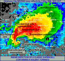
Over the next 20 minutes, NWS Norman watched the cell get that classic hook look, and could look on local TV to see what the storm was doing
Realizing that a high end tornado was bearing down on the Oklahoma City metro area, the NWS Norman forecasters tried to find a way to better communicate that there was a deadly tornado about to hit a highly populated area... and at 6:57 PM meteorologist David Andra issued the first ever tornado emergency
That tornado would be the Bridge Creek/Moore F5... 36 people died directly from the storm and 5 more died afterwards with nearly 600 injured
It would be a significant tornado in another way... the idea that taking cover from a tornado underneath an overpass was also (FINALLY in the eyes of some meteorologists) debunked as at least 3 people died and several others seriously injured while hiding in the upper corners of overpass bridges
YouTube - KFOR live coverage of Bridge Creek/Moore F5 tornado 5/3/99


I mean... if you lived in SE Louisiana for Hurricane Katrina then you're aware of the dire "Most of the area will be uninhabitable for weeks... perhaps longer" warning from NWS New Orleans on the morning of 8/28/05
Such was the case on May 3, 1999, a somewhat unexpected tornado outbreak day in the central plains.
The NWS Storm Prediction Center had only given the day a "slight" chance of severe weather (2/5) during the early morning, but by early-afternoon the SPC realized the atmosphere was set-up for a significant severe weather outbreak and, after getting their buddies down the hall at the Norman, Okla. local forecast office to do an unscheduled weather balloon release, bumped up the risk all the way up to "high" (5/5) for most of Oklahoma.
At 3:30 PM, a rain cell started to catch the eye of the forecasters at NWS Norman and a severe thunderstorm warning was issued
About 45 minutes later, that same cell started to look tornadic, and the day's 1st tornado warning was issued
Over the next 2 hours, that cell continued to cycle, dropping several tornadoes along its path...
Then, around 6:30 PM, it put down yet another tornado, but one that would change the way tornado warnings are sent out forever.
Over the next 20 minutes, NWS Norman watched the cell get that classic hook look, and could look on local TV to see what the storm was doing
Realizing that a high end tornado was bearing down on the Oklahoma City metro area, the NWS Norman forecasters tried to find a way to better communicate that there was a deadly tornado about to hit a highly populated area... and at 6:57 PM meteorologist David Andra issued the first ever tornado emergency
quote:
SEVERE WEATHER STATEMENT
NATIONAL WEATHER SERVICE NORMAN OK
657 PM CDT MON MAY 3 1999
...TORNADO EMERGENCY IN SOUTH OKLAHOMA CITY METRO AREA...
AT 657 PM CDT...A LARGE TORNADO WAS MOVING ALONG INTERSTATE 44 WEST
OF NEWCASTLE. ON ITS PRESENT PATH...THIS LARGE DAMAGING TORNADO
WILL ENTER SOUTHWEST SECTIONS OF THE OKLAHOMA CITY METRO AREA
BETWEEN 715 PM AND 730 PM. PERSONS IN MOORE AND SOUTH OKLAHOMA CITY
SHOULD TAKE IMMEDIATE TORNADO PRECAUTIONS
THIS IS AN EXTREMELY DANGEROUS AND LIFE THREATENING SITUATION. IF
YOU ARE IN THE PATH OF THIS LARGE AND DESTRUCTIVE TORNADO...TAKE
COVER IMMEDIATELY.
DOPPLER RADAR INDICATED THIS STORM MAY CONTAIN DESTRUCTIVE HAIL TO
THE SIZE OF BASEBALLS...OR LARGER.
LAT...LON 3524 9784 3511 9769 3536 9735 3552 9754
ANDRA
That tornado would be the Bridge Creek/Moore F5... 36 people died directly from the storm and 5 more died afterwards with nearly 600 injured
It would be a significant tornado in another way... the idea that taking cover from a tornado underneath an overpass was also (FINALLY in the eyes of some meteorologists) debunked as at least 3 people died and several others seriously injured while hiding in the upper corners of overpass bridges
YouTube - KFOR live coverage of Bridge Creek/Moore F5 tornado 5/3/99
 9
9


Posted on 5/3/20 at 12:58 pm to rt3
The Moore tornado was a watershed moment in meteorological history. So powerful.


Posted on 5/3/20 at 12:59 pm to rt3
Getting hit at night and early morning was always the worst.
Eerie to be woken up to an even darker room with no power, and hearing that roar in the distance..not knowing which direction its headed
Eerie to be woken up to an even darker room with no power, and hearing that roar in the distance..not knowing which direction its headed

Posted on 5/3/20 at 1:00 pm to rt3
So much for well-built houses


Posted on 5/3/20 at 1:03 pm to Mr Wonderful
quote:
So much for well-built houses
Good luck finding a house that can withstand a F5
This post was edited on 5/3/20 at 1:04 pm


Posted on 5/3/20 at 1:11 pm to rt3
All the houses are destroyed but the cars are in perfect condition ....
Posted on 5/3/20 at 1:13 pm to GeorgeTheGreek
quote:
All the houses are destroyed but the cars are in perfect condition ....
something tells me the cars weren't anywhere near the tornado when it actually rolled through
Posted on 5/3/20 at 1:14 pm to rt3
Maybe.... or maybe there’s more that the media is hiding....
Posted on 5/3/20 at 1:15 pm to rt3
if you want to know what being "maybe a bit too close" to a F5 tornado is like...
go to 31:50 in the YouTube link I posted in the OP
go to 31:50 in the YouTube link I posted in the OP
Posted on 5/3/20 at 1:16 pm to GeorgeTheGreek
quote:
Maybe.... or maybe there’s more that the media is hiding....
yeah... my explanation sounds a lot better than yours
ETA: link in OP... 1:19:50... cars blown a good ways off of I-40 by the tornado
This post was edited on 5/3/20 at 1:21 pm

Posted on 5/3/20 at 2:24 pm to RollTide1987
quote:
The Moore tornado was a watershed moment in meteorological history. So powerful.
a mobile doppler radar recorded wind speeds of 301 mph (+/- 20 mph) in the Bridge Creek/Moore tornado
highest wind speed ever recorded ON EARTH

Posted on 5/3/20 at 3:27 pm to rt3
As bad as the 2013 Moore tornado was, the El Reno one on May 31st was bigger. 2.5 mile wide. strongest winds recorded. One chaser died in the storm


Posted on 5/3/20 at 3:33 pm to rt3
I remember this day vividly.
Posted on 5/3/20 at 3:35 pm to rt3
Man hard to believe this was 21 years ago.

Posted on 5/3/20 at 3:44 pm to rt3
Now, if only they can change the "slight", "moderate", and "enhanced" risks to something else
Posted on 5/3/20 at 3:45 pm to rt3
that video and new coverage - sad and incredible at the same time
Posted on 5/3/20 at 3:47 pm to Pisco
quote:
As bad as the 2013 Moore tornado was, the El Reno one on May 31st was bigger. 2.5 mile wide. strongest winds recorded. One chaser died in the storm
Thought it was four. Tim Samaras and his team.
Posted on 5/3/20 at 4:14 pm to Pisco
Why does it say on this video that I watched, el reno was the widest but was f3. I know they mean two different things but you said f5 and the video said f3. It's on YouTube
This post was edited on 5/3/20 at 4:15 pm
Posted on 5/3/20 at 4:21 pm to NWarty
quote:
Thought it was four. Tim Samaras and his team.
yeah it was more than 1... the members of Samaras' team
Posted on 5/3/20 at 4:23 pm to rt3
Ok sheep 

 Page 1 of 2

Popular
Back to top
 Follow TigerDroppings for LSU Football News