- My Forums
- Tiger Rant
- LSU Recruiting
- SEC Rant
- Saints Talk
- Pelicans Talk
- More Sports Board
- Coaching Changes
- Fantasy Sports
- Golf Board
- Soccer Board
- O-T Lounge
- Tech Board
- Home/Garden Board
- Outdoor Board
- Health/Fitness Board
- Movie/TV Board
- Book Board
- Music Board
- Political Talk
- Money Talk
- Fark Board
- Gaming Board
- Travel Board
- Food/Drink Board
- Ticket Exchange
- TD Help Board
Customize My Forums- View All Forums
- Show Left Links
- Topic Sort Options
- Trending Topics
- Recent Topics
- Active Topics
Started By
Message
 2
2

Posted on 5/20/19 at 10:47 pm to rt3
storm east of Tulsa doesn't look very friendly
Posted on 5/20/19 at 10:50 pm to rt3
Leach, Okla. is getting fud up right now

Posted on 5/20/19 at 10:51 pm to rt3
Local weather confirms large tornado on ground just south of 412
Posted on 5/20/19 at 10:52 pm to Hawgeye
the couplet that would be that tornado is right on the marker for Leach, Okla.
like the tornado is right in the middle of town if it's still on the ground
like the tornado is right in the middle of town if it's still on the ground
Posted on 5/20/19 at 10:53 pm to Hawgeye
I'm amazed this didn't travel any more southeast and come close to our NWA populated corner. Wondering if Springfield, Mo. is going to see something tho
Posted on 5/20/19 at 10:53 pm to rt3
tornado EMERGENCY was issued for Leach, Okla.
Posted on 5/20/19 at 10:54 pm to rt3
Good bet that's on the ground. Not liking the last CC scan.
NE OK over producing on the tornado front this evening.
NE OK over producing on the tornado front this evening.
Posted on 5/20/19 at 10:54 pm to Sao
quote:
Wondering if Springfield, Mo. is going to see something tho
NAIA Softball World Series is set to start there later this week... the 10 teams that qualified are on their way there now
Posted on 5/20/19 at 11:01 pm to Duke
quote:
Good bet that's on the ground. Not liking the last CC scan.
NE OK over producing on the tornado front this evening.
TWC saying the radar showed the rotation may have been elongating out just as it entered Leach
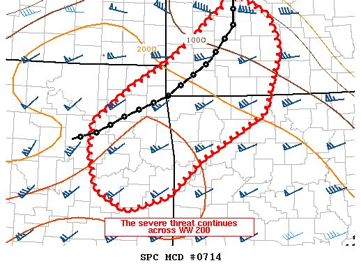
Posted on 5/20/19 at 11:09 pm to rt3
Posted on 5/20/19 at 11:11 pm to rt3
Posted on 5/20/19 at 11:12 pm to rt3
Never want to be in a MD that small.
Posted on 5/20/19 at 11:13 pm to rt3
OKc is scary right now. About to go to the stairwell
Posted on 5/20/19 at 11:14 pm to Duke
quote:
Never want to be in a MD that small.
care to elaborate outside of the obvious?
Posted on 5/20/19 at 11:16 pm to rt3
quote:
care to elaborate outside of the obvious?
They don't issue mesoscale discussions for an area that small unless it's incredibly notable.
Posted on 5/20/19 at 11:17 pm to slackster
Area just east of Wagoner, OK might get warned soon.
Posted on 5/20/19 at 11:18 pm to slackster
Remember the Lee County tornado? There was a tiny MCD about 30 minutes before.
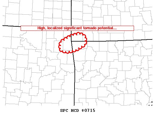
Posted on 5/20/19 at 11:19 pm to rt3
quote:
DISCUSSION...A supercell initially over Mayes/Cherokee Counties in Oklahoma favorably interacted with an outflow boundary and generated an intense mesocyclone, with experimental guidance suggestive of a significant tornado in the area. Strong rotation continues on radar, and significant tornado potential will exist with this storm as it migrates east-northeastward through Delaware County, OK; Benton County, AR; and McDonald County, MO through 05Z as long as it can remain rooted near the outflow boundary.
Posted on 5/20/19 at 11:21 pm to Duke
quote:
Remember the Lee County tornado? There was a tiny MCD about 30 minutes before.
when was this particular tornado?

 Page 29 of 31

Popular
Back to top