- My Forums
- Tiger Rant
- LSU Score Board
- LSU Recruiting
- SEC Rant
- SEC Score Board
- Saints Talk
- Pelicans Talk
- More Sports Board
- Coaching Changes
- Fantasy Sports
- Golf Board
- Soccer Board
- O-T Lounge
- Tech Board
- Home/Garden Board
- Outdoor Board
- Health/Fitness Board
- Movie/TV Board
- Book Board
- Music Board
- Political Talk
- Money Talk
- Fark Board
- Gaming Board
- Travel Board
- Food/Drink Board
- Ticket Exchange
- TD Help Board
Customize My Forums- View All Forums
- Show Left Links
- Topic Sort Options
- Trending Topics
- Recent Topics
- Active Topics
Started By
Message
 2
2

Posted on 5/20/19 at 1:21 pm to ElOsoBlanco7
quote:
I remember James Spann going on about how they were observing values over 10 during the 2011 outbreak. He was saying they hadn't seen anything over 10 before then. Hopefully today is a bust, but man, these ingredients are really lining up.
YouTube - James Spann on 4/27/11
quote:
12.2 on the significant tornado index. We've never seen numbers like this on this system. We've had this system for about 3 years now.

Posted on 5/20/19 at 1:22 pm to wfallstiger
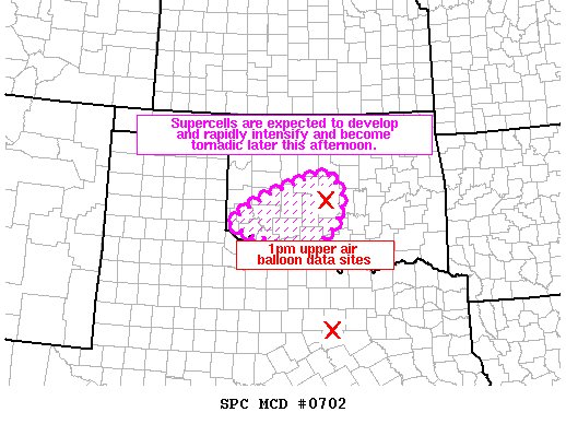
Mesoscale Discussion 0702
NWS Storm Prediction Center Norman OK
0121 PM CDT Mon May 20 2019
Areas affected...southwest and central OK
Concerning...Severe potential...Watch needed soon
Valid 201821Z - 201845Z
Probability of Watch Issuance...95 percent
SUMMARY...Environmental signals are continuing to point towards a
tornado outbreak with multiple strong to potentially violent
tornadoes across portions of western and central OK later this
afternoon into the evening.
DISCUSSION...Visible imagery shows a bubbling and destabilizing
boundary layer with upwards of 4000-4500 J/kg MLCAPE developing
across the warm sector over western and central OK. Surface
dewpoints are rising through the lower 70s degrees F across western
and central OK.
The 18z Fort Worth, TX upper air balloon showed a capping inversion
located just below 700mb. Recent runs of the RAP model show this
inversion less pronounced farther north. Despite temperatures
warming into the lower 80s over north TX into southwest OK, this
capping inversion has delayed convective initiation. This is
concerning for 2 reasons: 1) the wind profile continues to
strengthen across southwest and central OK with the Norman, OK upper
air balloon sampling 50kt flow around 850mb which is about 1-2 hours
earlier than forecast soundings were showing. 2) It does not appear
many storms will develop across southwest OK and resulting in
destructive storm-to-storm interference. In other words, tornadic
potential appears very high. Storms will likely initiate on the
north-end of the cloud streets over southwestern OK in the hotter
air and intensify and move northeast towards the I-40 and I-35
corridors later.
As such, the very rare combination of shear/buoyancy with many hours
of run-to-run consistency of the HRRR model showing discrete
supercells all point to a tornado outbreak developing later this
afternoon featuring strong to violent long-track tornadoes.

Posted on 5/20/19 at 1:24 pm to lsuman25
quote:
According to TWC it's in the 80s in some parts of Oklahoma south of the warm front.
I would assume that is out west then. Our local guys are only saying about 73 or 74 once it arrives here.
Just looked on my phone and about 2 hours south of us it is 76 in McAlester, OK.
Posted on 5/20/19 at 1:24 pm to Hawgeye
quote:
It is just an odd set up. Normally on tornado days, you can feel the humidity in the air. It is muggy, and you just know storms are coming. Today though, it was 55 when I woke up and went on my back patio. No humidity what so ever. Even just low 60's when I came home from the
Dew Points at 5PM:

Posted on 5/20/19 at 1:24 pm to lsuman25
quote:
According to TWC it's in the 80s in some parts of Oklahoma south of the warm front.
80s here
they are sending us home
Posted on 5/20/19 at 1:24 pm to rt3
At one point i think it went 17.5 or something insane like that.
Posted on 5/20/19 at 1:25 pm to Bedhog
quote:
The sound of that tornado behind the tornado sirens is about as eerie of a sound you'll ever hear.
Yeah, that was spooky. That and the dead calm before it hit.
Posted on 5/20/19 at 1:25 pm to GEAUXmedic
Posted on 5/20/19 at 1:26 pm to Hawgeye
quote:
in McAlester, OK
Currently here for work. Threat looks more to my west...fingers crossed.
Posted on 5/20/19 at 1:28 pm to rt3
quote:
12.2 on the significant tornado index. We've never seen numbers like this on this system. We've had this system for about 3 years now.
Well a 15.5 is pretty terrifying then...

Posted on 5/20/19 at 1:28 pm to StraightCashHomey21
quote:
80s here they are sending us home
Stay safe.
Posted on 5/20/19 at 1:30 pm to GEAUXmedic
quote:
It does not appear
many storms will develop across southwest OK and resulting in
destructive storm-to-storm interference.
So basically, no clustering?
Posted on 5/20/19 at 1:31 pm to Tdot_RiverDawg
quote:
Currently here for work. Threat looks more to my west...fingers crossed.
Yea. It is more up towards me in Broken Arrow. I think I-40 and north is where the greater chances are going to be. They always seem to fire up around Okmulgee, OK or Okemah, OK and head our way.
Btw, have you visited Pete's Place just outside of McAlester? Pretty good Italian joint and brewery.
Posted on 5/20/19 at 1:34 pm to Hawgeye
quote:
Stay safe.
well i have to stay
essential personnel
Posted on 5/20/19 at 1:37 pm to TidenUP
quote:i've really never heard a tornado personally or on audio. That was wicked for sure.
Yeah, that was spooky. That and the dead calm before it hit.
Posted on 5/20/19 at 1:37 pm to Hawgeye
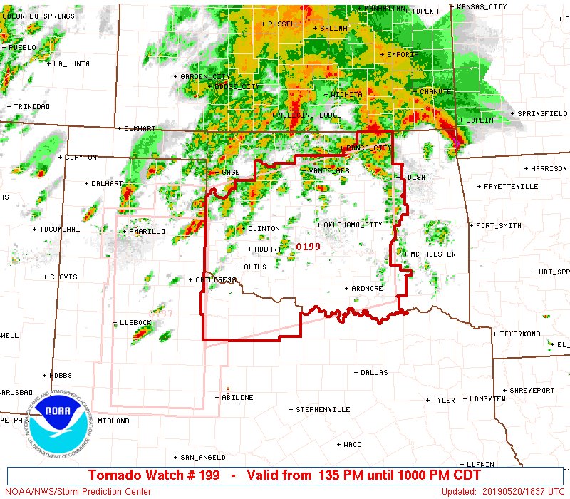
NEW PDS Tornado Watch covering a good part of central Oklahoma
Posted on 5/20/19 at 1:37 pm to Hawgeye
Looks like the new watch that is about to be put out in Oklahoma is going to put me on the very east side of the watch.
Crap
Crap
Posted on 5/20/19 at 1:38 pm to Hawgeye
Posted on 5/20/19 at 1:38 pm to rt3
quote:
URGENT - IMMEDIATE BROADCAST REQUESTED
Tornado Watch Number 199
NWS Storm Prediction Center Norman OK
135 PM CDT Mon May 20 2019
The NWS Storm Prediction Center has issued a
* Tornado Watch for portions of
Central and Western Oklahoma
Northwest Texas
* Effective this Monday afternoon and evening from 135 PM until
1000 PM CDT.
...THIS IS A PARTICULARLY DANGEROUS SITUATION...
* Primary threats include...
Numerous tornadoes and several intense tornadoes expected
Widespread damaging winds and scattered significant gusts to 80
mph expected
Widespread large hail and scattered very large hail events to 4
inches in diameter expected
SUMMARY...An outbreak of tornadoes, including the risk of intense
and long-track tornadoes, is expected to develop this afternoon
across the watch area. Very large hail and damaging wind gusts are
expected with the numerous supercell storms.
The tornado watch area is approximately along and 95 statute miles
north and south of a line from 40 miles west of Altus OK to 50 miles
east southeast of Chandler OK. For a complete depiction of the watch
see the associated watch outline update (WOUS64 KWNS WOU9).
PRECAUTIONARY/PREPAREDNESS ACTIONS...
REMEMBER...A Tornado Watch means conditions are favorable for
tornadoes and severe thunderstorms in and close to the watch
area. Persons in these areas should be on the lookout for
threatening weather conditions and listen for later statements
and possible warnings.
&&
OTHER WATCH INFORMATION...CONTINUE...WW 197...WW 198...
AVIATION...Tornadoes and a few severe thunderstorms with hail
surface and aloft to 4 inches. Extreme turbulence and surface wind
gusts to 70 knots. A few cumulonimbi with maximum tops to 600. Mean
storm motion vector 23035.
...Hart

 Page 10 of 31

Popular
Back to top