- My Forums
- Tiger Rant
- LSU Recruiting
- SEC Rant
- Saints Talk
- Pelicans Talk
- More Sports Board
- Fantasy Sports
- Golf Board
- Soccer Board
- O-T Lounge
- Tech Board
- Home/Garden Board
- Outdoor Board
- Health/Fitness Board
- Movie/TV Board
- Book Board
- Music Board
- Political Talk
- Money Talk
- Fark Board
- Gaming Board
- Travel Board
- Food/Drink Board
- Ticket Exchange
- TD Help Board
Customize My Forums- View All Forums
- Show Left Links
- Topic Sort Options
- Trending Topics
- Recent Topics
- Active Topics
Started By
Message
re: UPDATE: Another Potential Severe Weather Event for the South (insert dates)
Posted on 3/25/21 at 5:18 pm to Woopigsooie20

Posted on 3/25/21 at 5:18 pm to Woopigsooie20
quote:
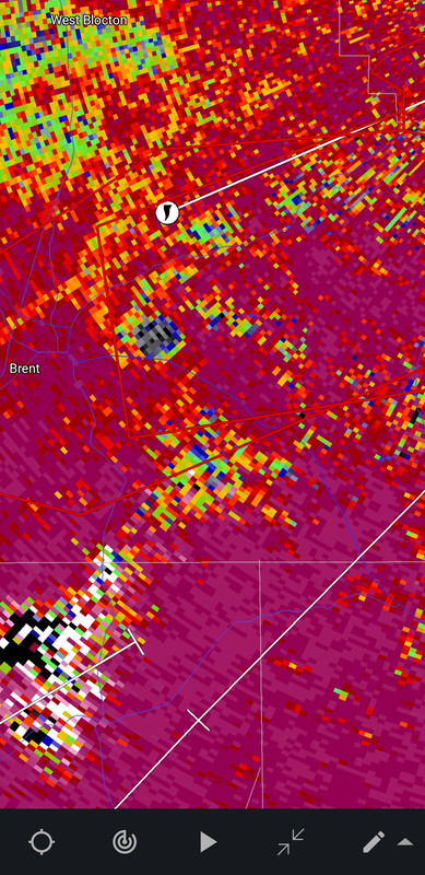
Debris ball got even darker..
It might have wiped out Bibb Correctional
 0
0

Posted on 3/25/21 at 5:18 pm to rt3
idk wtf he was doing, he was hauling it down a 2 lane road and there was a guy slowing down in front of him to make a left turn and he tried going around him while the dude was making a left turn
Posted on 3/25/21 at 5:18 pm to LegendInMyMind
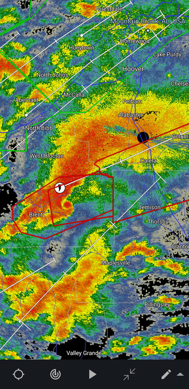
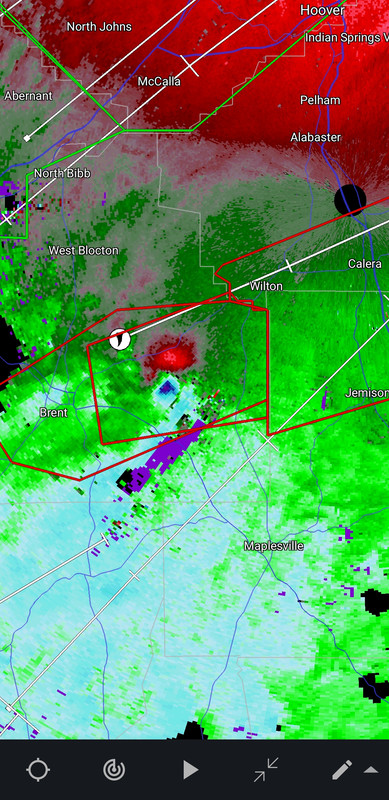
TWC estimating that the Brent/Centreville tornado has already been on the ground for 40 miles

Posted on 3/25/21 at 5:18 pm to LegendInMyMind

Posted on 3/25/21 at 5:19 pm to rt3
quote:
TWC estimating that the Brent/Centreville tornado has already been on the ground for 40 miles
It ain't stopping anytime soon. I haven't even seen it cycle.
Posted on 3/25/21 at 5:19 pm to rt3
It's unbelievable to have a supercell this strong this close to a radar site. The imagery is incredible on reflectivity. They might put this reflectivity in textbooks.
Posted on 3/25/21 at 5:19 pm to LegendInMyMind
North of US 82 east of Centerville now

Posted on 3/25/21 at 5:20 pm to LegendInMyMind
S Shelby is about to get wrecked
Posted on 3/25/21 at 5:21 pm to LegendInMyMind
That looks like tyhe JOPLIN tornado signature - bad
Gary Springs taking the hit now
Gary Springs taking the hit now
This post was edited on 3/25/21 at 5:22 pm
Posted on 3/25/21 at 5:21 pm to LegendInMyMind
thing looks like a GD wrecking ball
Posted on 3/25/21 at 5:22 pm to rt3
Keeps wobbling around like a hurricane eye

Posted on 3/25/21 at 5:22 pm to LegendInMyMind
I’ve lived in this part of Alabama my entire life, and this is one of the most violent radar signatures I have ever seen here, and is probably the most violent I’ve seen in Alabama since 4/27/11.
Posted on 3/25/21 at 5:23 pm to HempHead
2.5 miles on the correlation coefficient now.
Posted on 3/25/21 at 5:24 pm to Roll Tide Ravens
quote:
I’ve lived in this part of Alabama my entire life, and this is one of the most violent radar signatures I have ever seen here, and is probably the most violent I’ve seen in Alabama since 4/27/11.
I don't care if my posting every frame is annoying. Seeing this is gutting me. Terrible situation is unfolding.
Posted on 3/25/21 at 5:24 pm to Roll Tide Ravens
quote:
I’ve lived in this part of Alabama my entire life, and this is one of the most violent radar signatures I have ever seen here, and is probably the most violent I’ve seen in Alabama since 4/27/11.
Doesn't hurt that it's close enough to the radar to kiss its a-hole

Posted on 3/25/21 at 5:24 pm to Roll Tide Ravens
Crazy how Alabama is getting these Midwest strength tornadoes the past few years. 15-20 years ago you’d associate these with Kansas, Oklahoma, Texas, etc...
Posted on 3/25/21 at 5:24 pm to Woopigsooie20
quote:
WSFA 12 News
@wsfa12news
Autauga, Tallapoosa, Coosa counties added to tornado watch until at least 8 p.m.

 Page 50 of 86

Back to top