- My Forums
- Tiger Rant
- LSU Recruiting
- SEC Rant
- Saints Talk
- Pelicans Talk
- More Sports Board
- Fantasy Sports
- Golf Board
- Soccer Board
- O-T Lounge
- Tech Board
- Home/Garden Board
- Outdoor Board
- Health/Fitness Board
- Movie/TV Board
- Book Board
- Music Board
- Political Talk
- Money Talk
- Fark Board
- Gaming Board
- Travel Board
- Food/Drink Board
- Ticket Exchange
- TD Help Board
Customize My Forums- View All Forums
- Show Left Links
- Topic Sort Options
- Trending Topics
- Recent Topics
- Active Topics
Started By
Message
re: UPDATE: Another Potential Severe Weather Event for the South (insert dates)
Posted on 3/25/21 at 12:20 pm to Thracken13
Posted on 3/25/21 at 12:20 pm to Thracken13
 0
0

Posted on 3/25/21 at 12:20 pm to LegendInMyMind
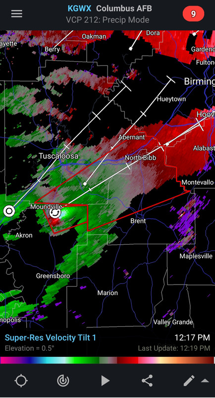
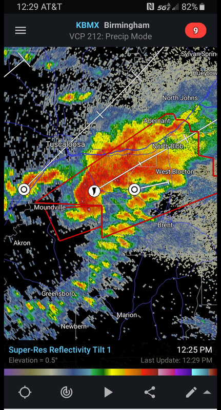
It’s a damn donut hole right now.
Posted on 3/25/21 at 12:21 pm to SouthernHog
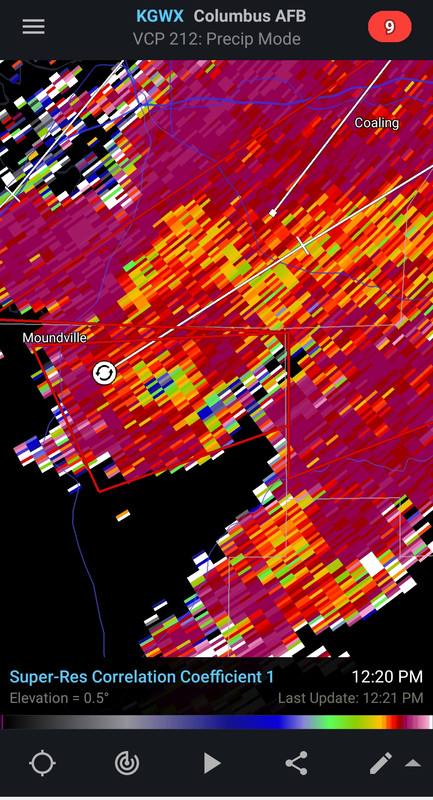
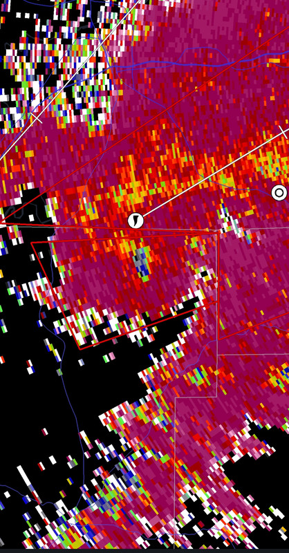
There's a debris signature showing up on it now.

Posted on 3/25/21 at 12:22 pm to deltaland
Confirmed tornado southeast of Moundville, AL. Debris signature showing up on radar.
Posted on 3/25/21 at 12:23 pm to Roll Tide Ravens
This thing could impact some really populated areas down the line if the current trajectory continues.
Posted on 3/25/21 at 12:23 pm to SouthernHog
quote:
It’s a damn donut hole right now.
BWER or Bounded Weak Echo Region.
That donut hole is a sign of a very powerful thunderstorm and it's typical to see the donut hole fade as you see a tornado mature. Which is what it looks like is happening right now.
Posted on 3/25/21 at 12:23 pm to deltaland
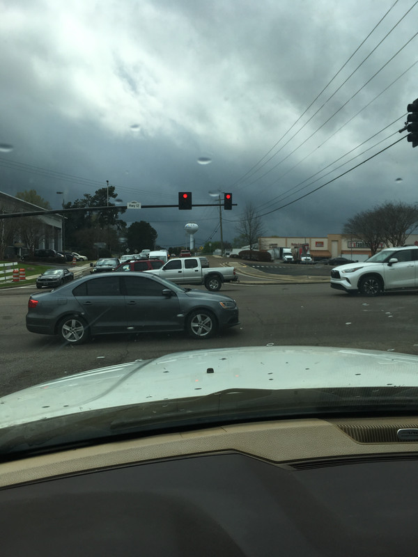
Leaving lunch in Starkville. Looking ominous to the south
Posted on 3/25/21 at 12:29 pm to LegendInMyMind
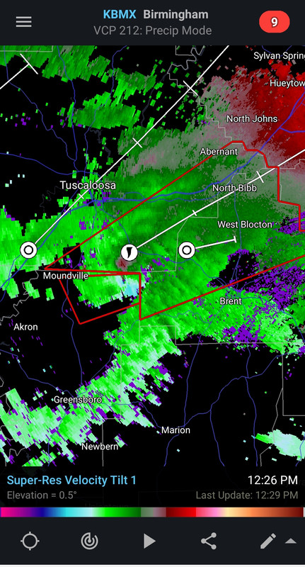
I can also see this storm is pulling liquid water well above the freezing level checking a high tilt of the zdr. Just another thing to confirm what we are seeing, a very powerful updraft still cranking away.
Posted on 3/25/21 at 12:29 pm to LegendInMyMind
Can’t believe none of the cells in MS don’t even have severe T storm warning

Posted on 3/25/21 at 12:30 pm to deltaland

Posted on 3/25/21 at 12:30 pm to Bobby OG Johnson

Posted on 3/25/21 at 12:31 pm to deltaland
quote:
Can’t believe none of the cells in MS don’t even have severe T storm warning
It’s still really early in the event, so I’m sure they’ll get going soon enough.
Posted on 3/25/21 at 12:31 pm to Bobby OG Johnson


Posted on 3/25/21 at 12:33 pm to Bobby OG Johnson
Spann said Moundville/Hale Co. is in the clear. Sister said it’s East of her.
Posted on 3/25/21 at 12:33 pm to Roll Tide Ravens
this MF is coming right at the 280 corridor out here near Greystone - told the wife to get important stuff in a bag in the closet - just in case
Posted on 3/25/21 at 12:33 pm to Duke
Radar showing another 4 - 6 developing supercells. The big question for the remainder of today - do those cell run interference on each other and eventually grow upscale into clusters and lines or do they take right turns and space out?
Posted on 3/25/21 at 12:34 pm to Roll Tide Ravens
quote:
...A TORNADO WARNING REMAINS IN EFFECT UNTIL 115 PM CDT FOR
SOUTHEASTERN TUSCALOOSA AND CENTRAL BIBB COUNTIES...
At 1230 PM CDT, a confirmed large and extremely dangerous tornado was
located over Low Gap, or 15 miles west of Brent, moving northeast at
45 mph.

 Page 23 of 86

Popular
Back to top