- My Forums
- Tiger Rant
- LSU Recruiting
- SEC Rant
- Saints Talk
- Pelicans Talk
- More Sports Board
- Coaching Changes
- Fantasy Sports
- Golf Board
- Soccer Board
- O-T Lounge
- Tech Board
- Home/Garden Board
- Outdoor Board
- Health/Fitness Board
- Movie/TV Board
- Book Board
- Music Board
- Political Talk
- Money Talk
- Fark Board
- Gaming Board
- Travel Board
- Food/Drink Board
- Ticket Exchange
- TD Help Board
Customize My Forums- View All Forums
- Show Left Links
- Topic Sort Options
- Trending Topics
- Recent Topics
- Active Topics
Started By
Message
re: UPDATE: Another Potential Severe Weather Event for the South (insert dates)
Posted on 3/24/21 at 9:18 am to Thracken13
Posted on 3/24/21 at 9:18 am to Thracken13
Our boy in CenLA thinks CenLA is looking better for tomorrow
quote:
Meteorologist Nick Mikulas
I continue to be the bearer of cautious optimism regarding our severe threat. It’s still conditional late this afternoon and evening, meaning we actually need storms to develop. If that happens, and that’s a big if, then we may see an isolated severe storm. That is pretty doubtful.
Thursday’s threat seems to be shifting a bit more to our northeast, and the worst of this one was always going to be northeast of us. We are still in a level 2, slight risk, but it wouldn’t surprise me if we snuck through this one with little to no severe weather. Don’t let my optimism come off as an all clear. It’s still possible we see a few severe storms in the morning or early afternoon, but things are trending in the right direction. I’ll update things this evening.
 0
0


Posted on 3/24/21 at 9:23 am to Tarps99
And the trustees just got done picking up all the trash that floated up a few days ago
Posted on 3/24/21 at 10:10 am to Roll Tide Ravens
quote:
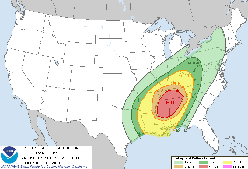
Moderate risk tomorrow (Thursday):
Interesting to see how SPC plays this, the 12z guidance is trending towards a less messy setup with more potential for discrete cells.
Posted on 3/24/21 at 11:20 am to rds dc
quote:
Interesting to see how SPC plays this, the 12z guidance is trending towards a less messy setup with more potential for discrete cells.
Another multi-round event, too with a line to finish it off tomorrow evening. 3k Nam shows a messy storm mode in the morning, particularly across North AL. There isn't alot of air between those cells, but the round starting in the afternoon around 2ish looks to be more discreet. The QLCS later in the evening could pack a punch, too.
Talk about "classic paths" this puts all of those North MS/AL paths in play if development plays out like that. Yay....I can't wait..../sarcasm
Posted on 3/24/21 at 11:32 am to tigerinthebueche
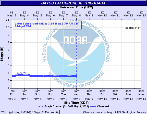
quote:
Turn de pumps on, bra!!
There was enough rain to raise the bayou almost 3 feet. The bayou is much narrower in Thibodaux than it is down here in SL. Doesn't seem like a lot, but on flat clay soil that is a LOT of water to do that without any rise from tides.
Posted on 3/24/21 at 11:50 am to tigersownall
Was flooded in most of the night last night, low part of Tunnel Blvd ,that always floods. Has for 30+ years. Someday it might be addressed.
Posted on 3/24/21 at 11:58 am to lsubuddy
Back Vacherie good. Thanks for asking.
Posted on 3/24/21 at 12:02 pm to lsubuddy
Anyone know how much water Venetian Isles is getting in Nola East? Is the Chef out of its banks?

Posted on 3/24/21 at 12:53 pm to rds dc
quote:
Interesting to see how SPC plays this, the 12z guidance is trending towards a less messy setup with more potential for discrete cells.
Yeah, that’s a big question. Would they pull the trigger on a high risk, or be more conservative given how the high risk last week didn’t exactly pan out? I guess we’ll see.
Posted on 3/24/21 at 12:54 pm to tgrbaitn08
tgrbaitn, would you mind including tomorrow’s severe threat in the thread title?
This post was edited on 3/24/21 at 12:55 pm
Posted on 3/24/21 at 12:56 pm to LessofLes
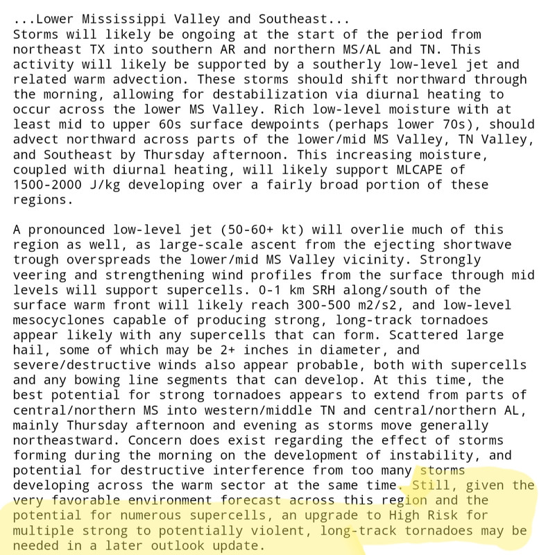
Moderate Risk shifted East and North, now covering all of North AL and most of Central and Southern TN. The "H Word" was also thrown in at the end of the discussion.
Posted on 3/24/21 at 12:59 pm to LegendInMyMind
If they go to a high risk, two high risks in almost the same places in an 8 day period is incredible.
Posted on 3/24/21 at 12:59 pm to Roll Tide Ravens
quote:
Yeah, that’s a big question. Would they pull the trigger on a high risk, or be more conservative given how the high risk last week didn’t exactly pan out? I guess we’ll see.
I think it will hinge on what storm mode is favoring. There's still not a whole lot of agreement across models on discreet super cells being the biggest players. NAM, like last week, is favoring a messier storm mode, while some others are going dooms day scenario. It probably falls somewhere in the middle.
This post was edited on 3/24/21 at 1:01 pm
Posted on 3/24/21 at 1:00 pm to Roll Tide Ravens
quote:
If they go to a high risk, two high risks in almost the same places in an 8 day period is incredible.
The last time it happened was in 2017, I believe.
ETA: Yep, April 2 and April 5, 2017. From @Brando_WX
This post was edited on 3/24/21 at 1:03 pm
Posted on 3/24/21 at 1:18 pm to lsubuddy
A fee more people will need to die before theu care to do anything
Posted on 3/24/21 at 1:31 pm to LegendInMyMind
quote:
Moderate Risk shifted East and North,
I would say it expanded east and north. The western and southern boundaries are still in same place it appears
Posted on 3/24/21 at 1:32 pm to deltaland
quote:
I would say it expanded east and north. The western and southern boundaries are still in same place it appears
Yeah, expanded is the better word.
Posted on 3/24/21 at 1:47 pm to rds dc
Kind of a sneaky threat emerging over Texas today and some expansion of the ENH or even an upgrade to MOD might still happen.

Posted on 3/24/21 at 2:42 pm to Roll Tide Ravens
quote:
If they go to a high risk, two high risks in almost the same places in an 8 day period is incredible.
Only problem is that people won't take this one as seriously, either way.
Due to the "bust" just a week ago, people will feel like the SPC is juat crying wolf again.
James Spann is going to have to double down on telling area people to prepare.
ETA: I wouldn't fully define last week as a "bust" , but since there were no major tornadoes, I just feel like the general public has already forgotten about last week
This post was edited on 3/24/21 at 2:45 pm
Posted on 3/24/21 at 3:51 pm to East Coast Band
I don’t disagree with you but I said it last week and I’ll say it again, with 25 tornadoes and idk how many houses leveled it’s a borderline miracle nobody was killed last week
I mean one lady survived by leaving her trailer, jumping in a ditch, and holding onto a tree
I mean one lady survived by leaving her trailer, jumping in a ditch, and holding onto a tree

 Page 10 of 86

Popular
Back to top