- My Forums
- Tiger Rant
- LSU Score Board
- LSU Recruiting
- SEC Rant
- SEC Score Board
- Saints Talk
- Pelicans Talk
- More Sports Board
- Coaching Changes
- Fantasy Sports
- Golf Board
- Soccer Board
- O-T Lounge
- Tech Board
- Home/Garden Board
- Outdoor Board
- Health/Fitness Board
- Movie/TV Board
- Book Board
- Music Board
- Political Talk
- Money Talk
- Fark Board
- Gaming Board
- Travel Board
- Food/Drink Board
- Ticket Exchange
- TD Help Board
Customize My Forums- View All Forums
- Show Left Links
- Topic Sort Options
- Trending Topics
- Recent Topics
- Active Topics
Started By
Message

 2
2


Posted on 7/2/21 at 9:49 pm to Cosmo
Hurricane Charley 2004 butt fricked Punta Gorda

Posted on 7/2/21 at 9:51 pm to Bobby OG Johnson
Nick needs to calm down

Posted on 7/2/21 at 9:58 pm to Bobby OG Johnson

Checks out
Posted on 7/2/21 at 10:04 pm to When in Rome
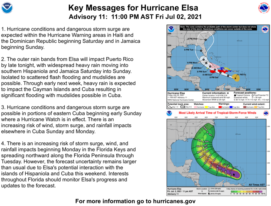
Looks like new cone half S shift right
Posted on 7/2/21 at 10:06 pm to Cosmo
Posted on 7/2/21 at 10:07 pm to Cosmo
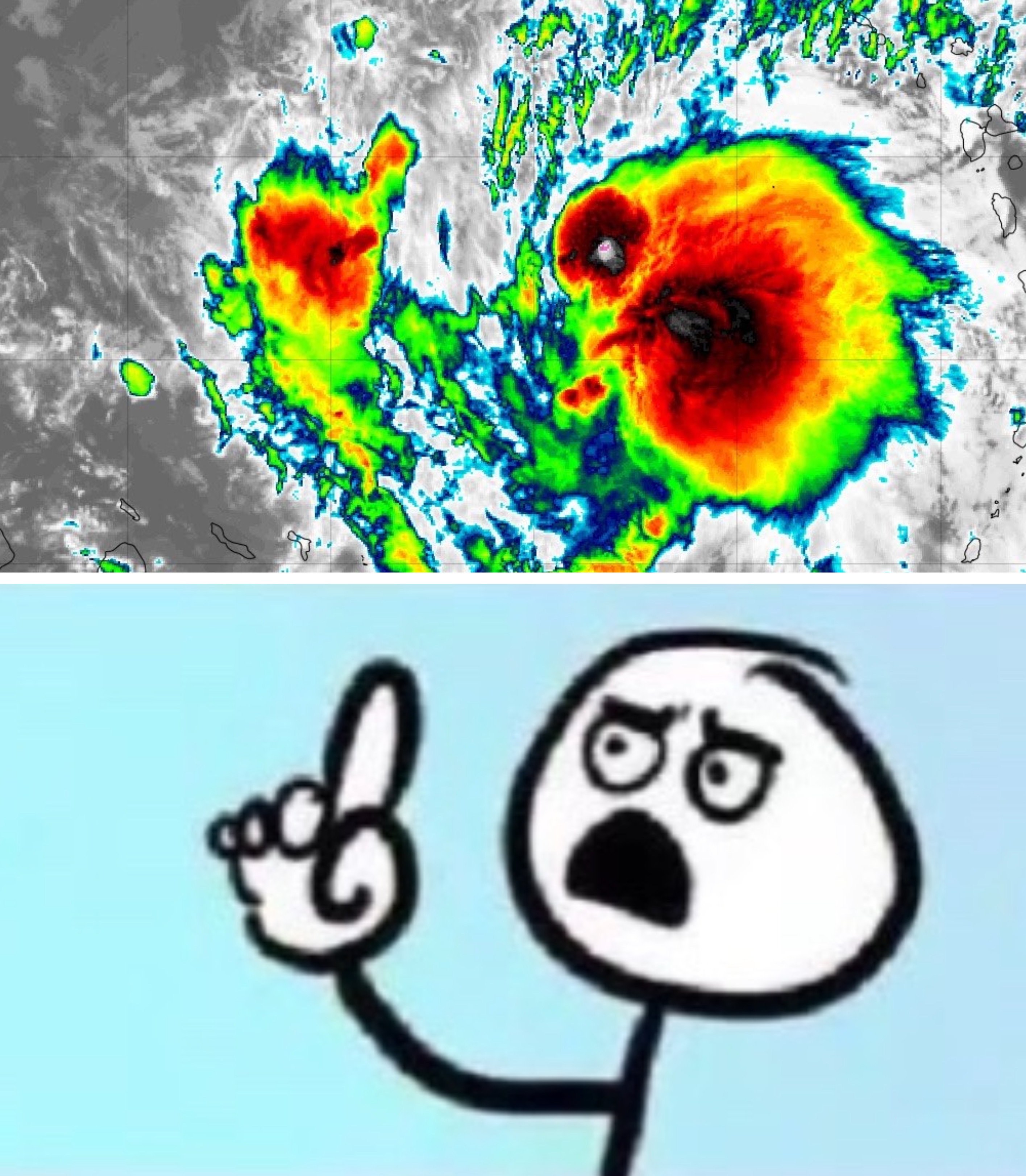
Elsa's fast forward speed and recent entrainment of dry mid-level
air into the western semicircle has eroded some of the inner-core
convection, resulting in the aforementioned weakening. In fact, NOAA
G-IV dropsondes launched around 2100 UTC northwest of Elsa indicated
a significant dry-air layer between 400-500-hPa that may have
been imported by moderate northwesterly mid-level shear. However, as
the cyclone's forward speed steadily decreases, the low-, mid-, and
upper-level circulations should become more vertically aligned,
which should allow for at least some slight re-strengthening during
the next 24 h or so. Possible interaction with the landmasses of
Haiti, southeastern Cuba, and Jamaica is the primary reason for not
showing a more robust intensity forecast given the very warm water
beneath the hurricane and a very favorable upper-level wind flow
regime. The latest GFS and UKMET models indicate that Elsa will be
moving into the center of a 300-200-mb synoptic-scale anticyclone,
which would produce enhanced outflow jets to the north and south of
the cyclone, resulting in significant strengthening. If Elsa ends up
'threading-the-needle' between Haiti, Jamaica, and Cuba, then
subsequent intensity forecasts may have to be increased similar to
the much stronger HWRF model. For now, the official NHC intensity
forecast maintains continuity with the previous advisory, and shows
only slight re-strengthening due to possible interaction with land.
ETA: Really good discussion for those interested in hurricane intensity stuff.
Makes sense why it's so good.
air into the western semicircle has eroded some of the inner-core
convection, resulting in the aforementioned weakening. In fact, NOAA
G-IV dropsondes launched around 2100 UTC northwest of Elsa indicated
a significant dry-air layer between 400-500-hPa that may have
been imported by moderate northwesterly mid-level shear. However, as
the cyclone's forward speed steadily decreases, the low-, mid-, and
upper-level circulations should become more vertically aligned,
which should allow for at least some slight re-strengthening during
the next 24 h or so. Possible interaction with the landmasses of
Haiti, southeastern Cuba, and Jamaica is the primary reason for not
showing a more robust intensity forecast given the very warm water
beneath the hurricane and a very favorable upper-level wind flow
regime. The latest GFS and UKMET models indicate that Elsa will be
moving into the center of a 300-200-mb synoptic-scale anticyclone,
which would produce enhanced outflow jets to the north and south of
the cyclone, resulting in significant strengthening. If Elsa ends up
'threading-the-needle' between Haiti, Jamaica, and Cuba, then
subsequent intensity forecasts may have to be increased similar to
the much stronger HWRF model. For now, the official NHC intensity
forecast maintains continuity with the previous advisory, and shows
only slight re-strengthening due to possible interaction with land.
ETA: Really good discussion for those interested in hurricane intensity stuff.
quote:
Forecaster Stewart/Papin
Makes sense why it's so good.
This post was edited on 7/2/21 at 10:12 pm
Posted on 7/2/21 at 10:10 pm to Duke
quote:triggering intensifies
Possible interaction with the landmasses of Haiti, southeastern Cuba, and Jamaica
Posted on 7/2/21 at 10:11 pm to rds dc
Will this knockdown the rest of the partially collapsed Miami condo?
Posted on 7/2/21 at 10:11 pm to Duke
I have a friends who lives outside of Orlando and said it’s not close enough to be even slightly worried or concerned — I would think she would be paying more attention with this 3/4 days out.
Posted on 7/2/21 at 10:11 pm to Duke
quote:
threading-the-needle
Another square
Posted on 7/2/21 at 10:16 pm to Jim Rockford

Sigh...
Never like to see that. Just as the disco mentioned.
Posted on 7/2/21 at 10:23 pm to Duke
quote:
Papin

Posted on 7/2/21 at 10:26 pm to Duke
quote:
Sigh...
Never like to see that. Just as the disco mentioned.
GFS has been so consistent on it shooting the gap since around 12z Tuesday the first time, and hasn't strayed much from it since.
This post was edited on 7/2/21 at 10:29 pm
Posted on 7/2/21 at 10:43 pm to When in Rome
When your wife does the laundry and you need to shower

*towels
*towels
Posted on 7/2/21 at 10:55 pm to Duke
Not looking nearly as good on the 00z GFS. It has still not stacked when it gets near Jamaica. It almost rips it apart, but it holds on at 1009mb as it approaches Cuba. More East on the Cuban landfall, and Cuba really knocks Elsa's dick in the dirt. It really slows down with it almost having a Westward motion across Cuba (first time we've seen that from the GFS). This run has it spending almost a whole day moving East to West across Cuba, and is around 1007mb when it leaves the island at around 12z Tuesday. Eventual FL landfall somewhere around the scrotal region at ~996mb. No hook to the East really after landfall. This run keeps it well away from the coast and takes it into North GA.
This post was edited on 7/2/21 at 11:25 pm
Posted on 7/2/21 at 10:55 pm to Duke
Hey weathermen... Thinking of planning a trip to Puerto Rico in September, October, or November. What month do hurricanes hit that area the most. I know there are certain times where the gulf is more likely to have one versus one starting out in the Atlantic.
Posted on 7/2/21 at 11:04 pm to Bobby OG Johnson
Posted on 7/2/21 at 11:09 pm to Bobby OG Johnson
GFS landfall near Mexico Beach
Posted on 7/2/21 at 11:10 pm to lsuman25
quote:
GFS landfall near Mexico Beach
Otherwise known as the scrotal region

 Page 37 of 49

Popular
Back to top