- My Forums
- Tiger Rant
- LSU Recruiting
- SEC Rant
- Saints Talk
- Pelicans Talk
- More Sports Board
- Coaching Changes
- Fantasy Sports
- Golf Board
- Soccer Board
- O-T Lounge
- Tech Board
- Home/Garden Board
- Outdoor Board
- Health/Fitness Board
- Movie/TV Board
- Book Board
- Music Board
- Political Talk
- Money Talk
- Fark Board
- Gaming Board
- Travel Board
- Food/Drink Board
- Ticket Exchange
- TD Help Board
Customize My Forums- View All Forums
- Show Left Links
- Topic Sort Options
- Trending Topics
- Recent Topics
- Active Topics
Started By
Message
re: Tropical Storm Nicholas - Flash Flood Watch for South Louisiana
Posted on 9/14/21 at 1:18 pm to LaBR4
Posted on 9/14/21 at 1:18 pm to LaBR4
quote:
Hurricane Nicholas was too much for the Hancock Whitney Bank on Perkins Rd/Kenilworth. Major structural damage
Just left that bank following up on a case.
The same branch was robbed last Friday.
Poor branch can’t catch a break. Or maybe they just did today thanks to a few investigative leads.
More to follow.
This post was edited on 9/14/21 at 1:19 pm
 2
2


Posted on 9/14/21 at 1:22 pm to The People
quote:
Just left that bank following up on a case.
Could have been you

Posted on 9/14/21 at 1:25 pm to The People
You FBI?

Posted on 9/14/21 at 1:26 pm to Duke
Again Duke, thank you.
Titty milk engaged
Titty milk engaged

Posted on 9/14/21 at 1:37 pm to LegendInMyMind
Looks like Lafayette is done thanks to dry air.
Or am I wrong?
Or am I wrong?
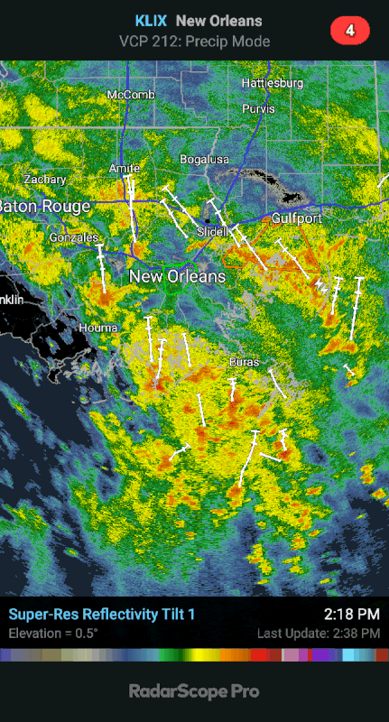
Posted on 9/14/21 at 1:41 pm to jcaz
quote:
Meteorologist Zack Fradella
2h ·
"RADAR UPDATE - we all are getting drenched but the rain has been manageable. Unfortunately the heaviest rain is currently falling in the hardest hit Ida areas of SE LA. Now one thing to note is Nicholas, the circulation, is about to find its way back into the Gulf. Don’t worry, it won’t reorganize but later tonight being that it’s farther south, the surface convergence with our coast could lead to much more intense rain bands. It’s something I’m watching closely. The approaching dry slot should help western LA get their rain totals cut down but the same can’t be said ahead of the circulation in south-central and southeast LA."
Sounds like Laffy aint out of the woods just yet
Posted on 9/14/21 at 1:47 pm to trussthetruzz
I agree with Zack's reasoning too.
Posted on 9/14/21 at 1:54 pm to trussthetruzz
quote:
Sounds like Laffy aint out of the woods just yet
Ah. Well damn
Posted on 9/14/21 at 2:23 pm to trussthetruzz
quote:
Sounds like Laffy aint out of the woods just yet
At this point I don't think anyone in SELA is out of the woods. If anything it looks to my untrained eye, that we stand a chance of getting more rain than expected..
Posted on 9/14/21 at 2:24 pm to trussthetruzz
quote:
Sounds like Laffy aint out of the woods just yet
Sounds more like the Basin and points eastward arent close to out of the woods
Lot of dry air west of the Basin now
Posted on 9/14/21 at 2:26 pm to Cosmo
New NHC map:

Posted on 9/14/21 at 2:27 pm to Y.A. Tittle
quote:
You FBI?
No, I don’t work for the political strong arm of the DNC.
Local guy.
Posted on 9/14/21 at 2:29 pm to Cosmo
That rain total map is flexing on us....
Posted on 9/14/21 at 2:32 pm to Cosmo
So I-10 east looks like a fun drive. Maybe bring along a trolling motor to hook to the tailgate in case you need it?

Posted on 9/14/21 at 2:32 pm to Cosmo
Not what Louisiana needs at all.. that looks like ALOT of rain….
Posted on 9/14/21 at 2:35 pm to Cosmo
That graphic falls in line with both the HRRR and NAM.
Posted on 9/14/21 at 2:37 pm to rt3
PIVOT
Posted on 9/14/21 at 2:38 pm to Cosmo
quote:
New NHC map:
they shite the bed with rainfall location totals imo.
Posted on 9/14/21 at 2:41 pm to Cosmo
I think this qualifies as being in low gear.
Posted on 9/14/21 at 2:42 pm to Chad504boy
quote:
they shite the bed with rainfall location totals imo.
Doesn't appear that way from radar and short range models.

 Page 42 of 55

Popular
Back to top