- My Forums
- Tiger Rant
- LSU Recruiting
- SEC Rant
- Saints Talk
- Pelicans Talk
- More Sports Board
- Fantasy Sports
- Golf Board
- Soccer Board
- O-T Lounge
- Tech Board
- Home/Garden Board
- Outdoor Board
- Health/Fitness Board
- Movie/TV Board
- Book Board
- Music Board
- Political Talk
- Money Talk
- Fark Board
- Gaming Board
- Travel Board
- Food/Drink Board
- Ticket Exchange
- TD Help Board
Customize My Forums- View All Forums
- Show Left Links
- Topic Sort Options
- Trending Topics
- Recent Topics
- Active Topics
Started By
Message
re: Tropical Storm Isaias - O Canada!
Posted on 8/3/20 at 10:04 am to NorthEndZone
Posted on 8/3/20 at 10:04 am to NorthEndZone
quote:
Yeah. Looks better on radar but pressure slowly rising. Will be mostly a rain flooding threat except for coastal winds and maybe a few trees down and power outages inland.
I still think it makes minimal hurricane by tonight. Organization is starting to happen as the shear drops and the dry air isn't as big of an issue. Plus it is going to start getting a little convection help on the west side from the jet starting to set up over the eastern US.
The disorder this morning just lowered the top end potential to 75-80 mph max.
 1
1


Posted on 8/3/20 at 11:41 am to Bobby OG Johnson
Report from Jax: nothing of note
Edit: oh no. Now we have rain drops as big as lemons.
Edit: oh no. Now we have rain drops as big as lemons.
This post was edited on 8/3/20 at 11:47 am

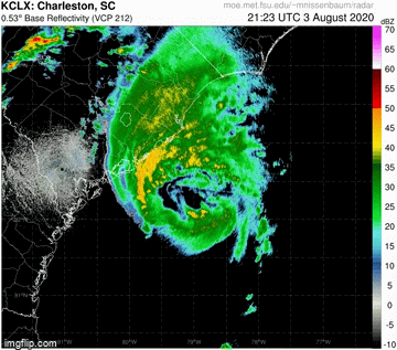
Posted on 8/3/20 at 11:54 am to roadGator
Some rain in Charleston, nothing of note yet.

Posted on 8/3/20 at 12:09 pm to PsychTiger

Posted on 8/3/20 at 12:31 pm to Roll Tide Ravens

Posted on 8/3/20 at 1:30 pm to Roll Tide Ravens

Certainly looks like it's building an inner core again. Also moving a little more NE than forecasted. Thinking we get a NC landfall on this.
Another aspect to note, Isaias doesn't lose much strength inland thanks to interacting with that trough. Highest 925 mb (800-1000 feet off ground give or take) winds from the Euro are when it's coming in at Jersey tomorrow. Not epic winds, but 80 kt range on the Euro. Looks to be a pain in the arse all the way up the east coast.

This post was edited on 8/3/20 at 1:38 pm
Posted on 8/3/20 at 1:33 pm to PsychTiger
Updated radar loop - 2:15 PM EDT through 4:00 PM EDT
Now has a closed off eye on radar...

Now has a closed off eye on radar...
This post was edited on 8/3/20 at 3:04 pm
Posted on 8/3/20 at 3:44 pm to NorthEndZone
I was hoping for two to three inches of rain here but we got hardly anything.
Now it's bright sunny and hot again
Now it's bright sunny and hot again
Posted on 8/3/20 at 3:59 pm to Puffoluffagus
Yeah. Another miss for the Georgia coast. Not a bad place to live if you want to avoid tropical storms and hurricanes.
But a hit will happen one day...
But a hit will happen one day...

Posted on 8/3/20 at 4:05 pm to Duke
You act like you WANT this to become a major storm and destroy peoples lives.... WTF is wrong with you??????
Posted on 8/3/20 at 4:14 pm to dukke v
Wilmington NC here. As of 5:12pm eastern, nothing. I know it is coming. We are under a tornado watch.
Ordered a pizza. Should get here in 10 minutes. Tipping the driver $20.
Ordered a pizza. Should get here in 10 minutes. Tipping the driver $20.
Posted on 8/3/20 at 4:18 pm to dukke v
quote:
You act like you WANT this to become a major storm and destroy peoples lives
Nobody is rooting for a hurricane. You're reading a lot of intent into an observation of better organization and pointing out the threat further north of the landfall point.

Posted on 8/3/20 at 5:14 pm to Duke
Is alex wilson on the weather channel just getting thick or is she pregnant?

Posted on 8/3/20 at 5:20 pm to Bobby OG Johnson
Gif of the lightning from yesterday morning

ETA Lightning from today

ETA Lightning from today
This post was edited on 8/3/20 at 5:22 pm
Posted on 8/3/20 at 5:41 pm to NorthEndZone
Buoy is getting into the eye...
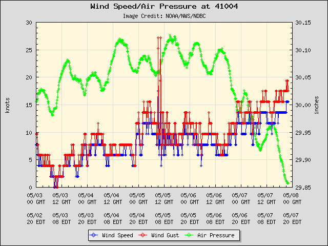
Posted on 8/3/20 at 6:15 pm to NorthEndZone
Buoy pressure bottomed-out at 989 mb and the winds were not totally calm. Lowest pressure is probably a few mb less at between 985 and 987 mb.
The latest advisory had 993 so it may have strengthened a little or the estimate was off a bit. Recon is almost there for a new center fix.
The latest advisory had 993 so it may have strengthened a little or the estimate was off a bit. Recon is almost there for a new center fix.
Posted on 8/3/20 at 6:24 pm to NorthEndZone
quote:
Recon is almost there for a new center fix.
986 extrapolated and 69 kt SFMR in SW quad.
Posted on 8/3/20 at 6:29 pm to Duke
Levi

quote:
Evening recon data indicates that #Isaias likely has regained hurricane intensity, with max winds of ~75mph found in the SW eyewall and a much lower central pressure than earlier today. Stronger winds may exist in the NE eyewall.

 Page 44 of 50

Popular
Back to top