- My Forums
- Tiger Rant
- LSU Recruiting
- SEC Rant
- Saints Talk
- Pelicans Talk
- More Sports Board
- Coaching Changes
- Fantasy Sports
- Golf Board
- Soccer Board
- O-T Lounge
- Tech Board
- Home/Garden Board
- Outdoor Board
- Health/Fitness Board
- Movie/TV Board
- Book Board
- Music Board
- Political Talk
- Money Talk
- Fark Board
- Gaming Board
- Travel Board
- Food/Drink Board
- Ticket Exchange
- TD Help Board
Customize My Forums- View All Forums
- Show Left Links
- Topic Sort Options
- Trending Topics
- Recent Topics
- Active Topics
Started By
Message
re: Tropical Storm Claudette - Heading Out Sea
Posted on 6/19/21 at 3:03 pm to Bobby OG Johnson
Posted on 6/19/21 at 3:03 pm to Bobby OG Johnson
There was probably one on the ground in the frame your circled. There was a CC drop for about two frames on it.
 1
1


Posted on 6/19/21 at 3:46 pm to LegendInMyMind
Unfortunately I’m having to link this from Facebook, but this is pretty impressive video of Claudette’s winds in Gulf Shores, AL this morning:
LINK
LINK

Posted on 6/19/21 at 3:56 pm to Roll Tide Ravens
quote:
National Hurricane Center
@NHC_Atlantic
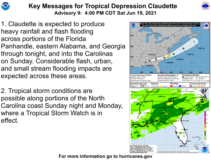
Tropical Depression #Claudette Advisory 9: Heavy Rains and Gusty Winds Continue Across Portions of The Southeast U.S.
Posted on 6/19/21 at 4:06 pm to Bobby OG Johnson
quote:
NWS Birmingham
@NWSBirmingham
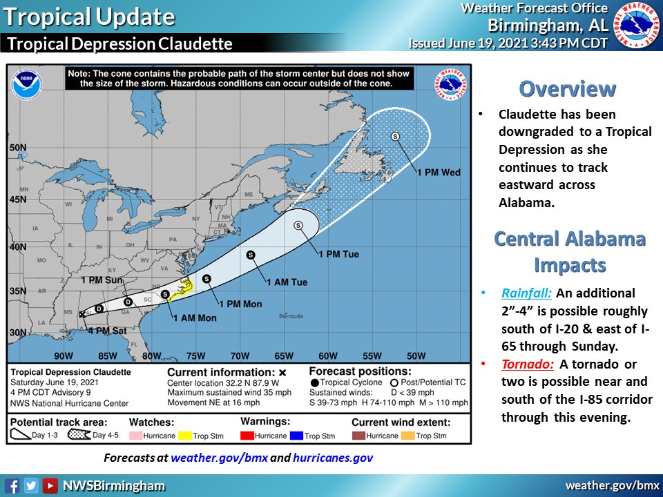
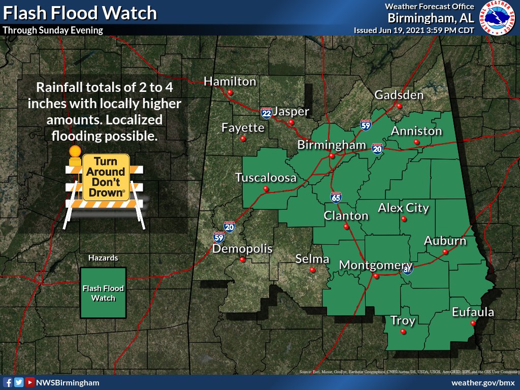
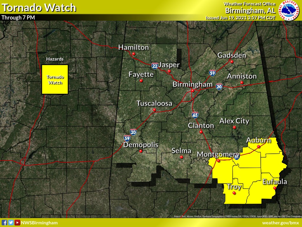
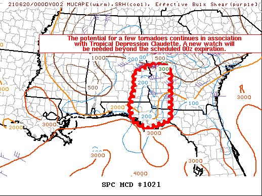
4PM UPDATE: #Claudette is now a Tropical Depression as she continues to move E across south AL. Localized flooding remains possible generally S of I-20 & E of I-65. An isolated tornado is also possible along/south of I-85 through this evening.
Posted on 6/19/21 at 4:31 pm to Bobby OG Johnson
Active weather everywhere today. Hell, a tornado warning in Maine just expired, and there is an active one in Ohio. Tomorrow looking like a high-end threat day from Iowa to Michigan with discreet supercell potential with big hail and tornadoes. Those storms will likely line out, too, and become a widespread wind event.
Posted on 6/19/21 at 4:33 pm to LegendInMyMind
wait... the NHC expects it to re-intensify back into a TS while over the Carolinas?
Posted on 6/19/21 at 4:37 pm to rt3
quote:
wait... the NHC expects it to re-intensify back into a TS while over the Carolinas?
It appears so. It isn't the craziest idea, remember the NAM was showing it looking better well inland.
Posted on 6/19/21 at 4:39 pm to rt3
quote:
National Weather Service
@NWS
The Tropical Storm Warning on the Gulf coast has been discontinued. Tropical storm conditions are possible along portions of the North Carolina coast Sunday night and Monday, where a Tropical Storm Watch is in effect.
Posted on 6/19/21 at 4:56 pm to LegendInMyMind
It rhymes with ratio...I mean kind of not really.
This post was edited on 6/19/21 at 4:57 pm
Posted on 6/19/21 at 4:57 pm to Bobby OG Johnson
Caption says Slidell. That waterline plus the new wood floor installation has got to be depressing to walk in on.

Posted on 6/19/21 at 5:03 pm to Duke
quote:
It rhymes with ratio...I mean kind of not really.
I'm not saying it.
Posted on 6/19/21 at 6:04 pm to LegendInMyMind
I bet it won’t rain tomorrow. Weatherman suck
Posted on 6/19/21 at 6:27 pm to Bobby OG Johnson

Posted on 6/19/21 at 7:09 pm to Bobby OG Johnson
All is well in Placencia, Belize except for all the fricking seaweed.
Posted on 6/19/21 at 7:15 pm to TigerBait1971
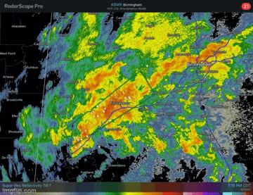
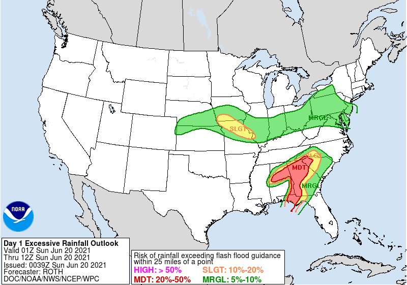
Relatively small area near Tuscaloosa now under a flash flood warning, expecting several more inches of rain.
I'm not in that area, and I've had 2 inches + of rain today.
I'm not in that area, and I've had 2 inches + of rain today.
Posted on 6/19/21 at 7:28 pm to East Coast Band
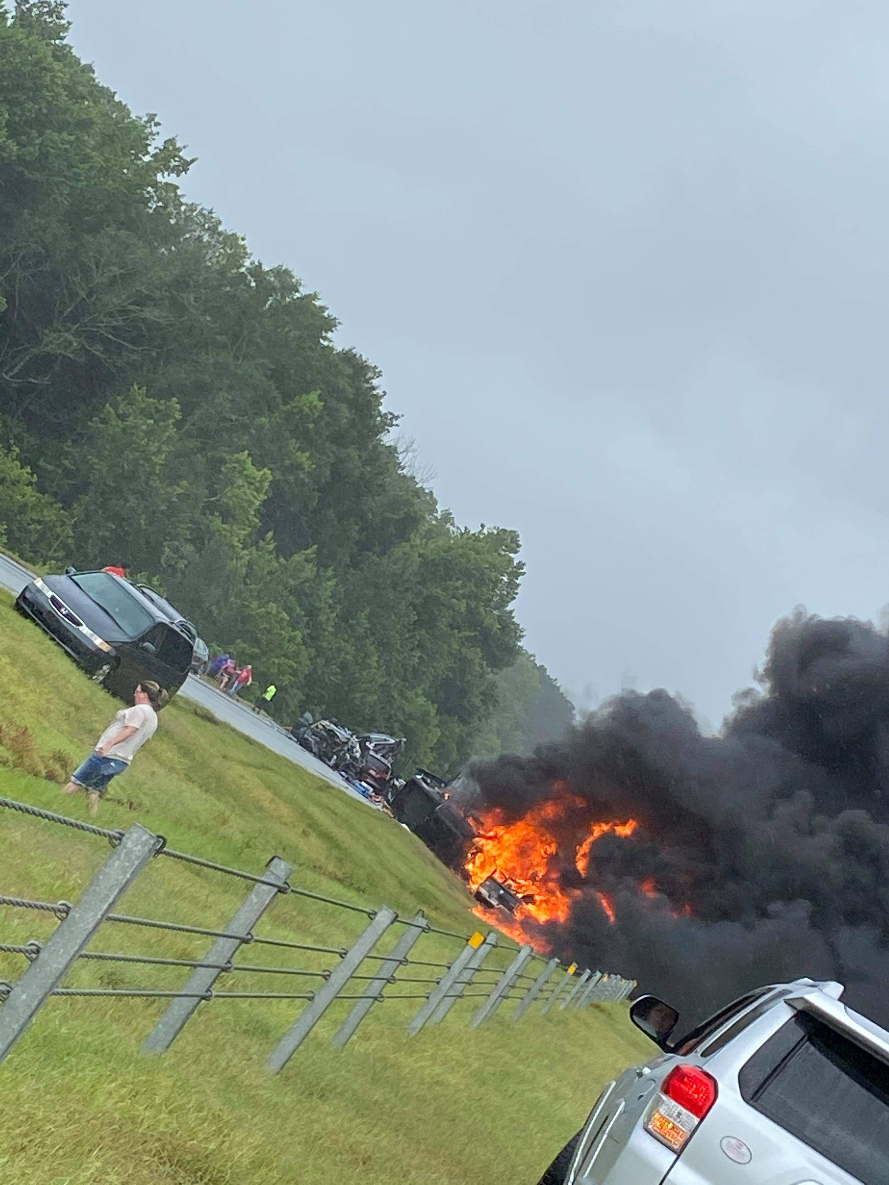
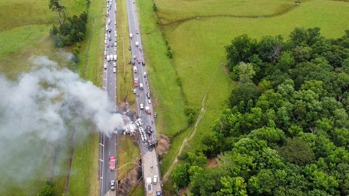
Deadly wreck on 65 near Greenville with multiple fatalities from earlier.
Prayers up for everyone involved.
Prayers up for everyone involved.
quote:
James Spann
@spann
Photo of the multiple vehicle crash on I-65 near Greenville earlier this afternoon from Rileigh Ray. The entire Interstate remains closed.
quote:
James Spann
@spann
This is the multi-car pileup on I-65 near Greenville that has the Interstate shut down. Drone photo from Chris Horn
Posted on 6/19/21 at 7:39 pm to Bobby OG Johnson
quote:
Stu Ostro
@StuOstro
Intense convective flareup near the center of #Claudette well inland with regenerating torrential downpours and flash #flooding -- an example of why you always need to be vigilant with tropical cyclones Cyclone #alwx

Posted on 6/19/21 at 7:41 pm to Bobby OG Johnson
quote:
NWS Birmingham
@NWSBirmingham
Heavy rain continues across Tuscaloosa with flash flooding already being reported. Additional flash flooding is likely over the next hour or so. Tuscaloosa Airport has measured 3.7” since 6 PM. #alwx
Posted on 6/19/21 at 7:46 pm to Bobby OG Johnson
Posted on 6/19/21 at 7:52 pm to Bobby OG Johnson
It is likely at this rate to be a Tropical Storm again before entering the Atlantic. The Euro strengthens it, GFS does not. This has been an odd system, for sure.
This post was edited on 6/19/21 at 7:52 pm

 Page 70 of 72

Popular
Back to top