- My Forums
- Tiger Rant
- LSU Recruiting
- SEC Rant
- Saints Talk
- Pelicans Talk
- More Sports Board
- Fantasy Sports
- Golf Board
- Soccer Board
- O-T Lounge
- Tech Board
- Home/Garden Board
- Outdoor Board
- Health/Fitness Board
- Movie/TV Board
- Book Board
- Music Board
- Political Talk
- Money Talk
- Fark Board
- Gaming Board
- Travel Board
- Food/Drink Board
- Ticket Exchange
- TD Help Board
Customize My Forums- View All Forums
- Show Left Links
- Topic Sort Options
- Trending Topics
- Recent Topics
- Active Topics
Started By
Message
re: Tropical Storm Claudette - Heading Out Sea
Posted on 6/14/21 at 11:17 am to GEAUXmedic
Posted on 6/14/21 at 11:17 am to GEAUXmedic
quote:
12z GFS
Relatively quick hitter as models are starting to pickup on some northern stream s/w that can pull the system out.
 1
1

Posted on 6/14/21 at 11:28 am to The Boat
quote:
They are pretty sweet
Here's one:
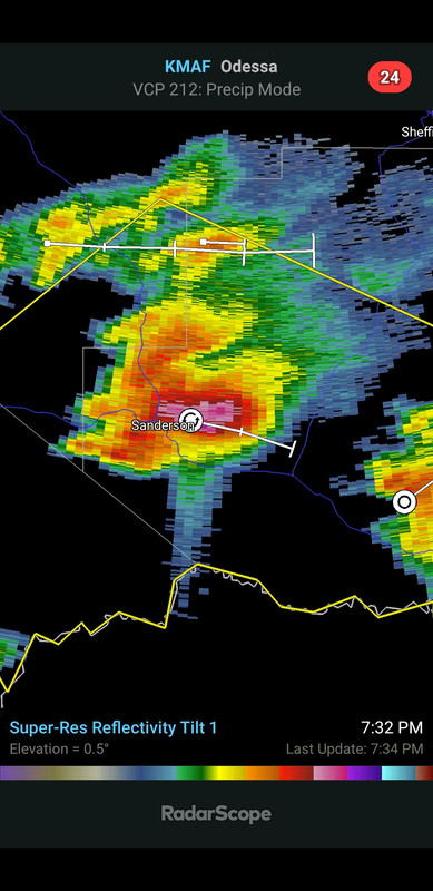

Posted on 6/14/21 at 11:31 am to LegendInMyMind
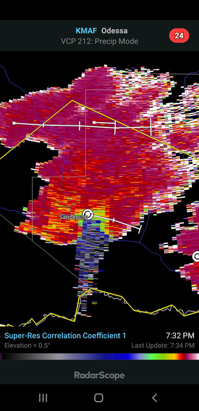
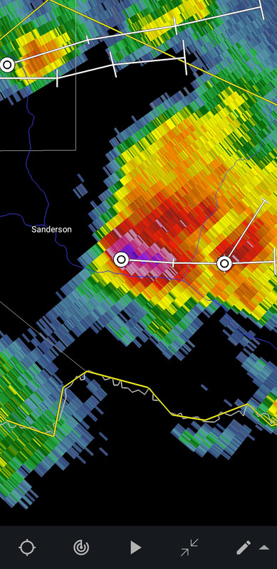
Yeah you can see them good on CC. You can also see the dark spot within the cell which is the "hail hole".
Posted on 6/14/21 at 11:37 am to The Boat
This was later in the life of that storm. It was putting down 4"+ hail at the time. Pretty cool to see the spike bleed into the developing storm behind it. That cell hailed its arse off for 3 hours or so.
/thread hijack
/thread hijack
Posted on 6/14/21 at 11:41 am to LegendInMyMind
quote:
Pretty cool to see the spike bleed into the developing storm behind it.
The spike doesn't actually exist. That's the radar beam getting refracted through all the ice.
Posted on 6/14/21 at 11:49 am to The Boat
quote:
The spike doesn't actually exist. That's the radar beam getting refracted through all the ice.
Yeah, the radar thinks what it is seeing is farther away than it actually is. The signal bounces off the stone, to the ground, back the stone, then returns to the radar, making the trip there and back longer.
I was talking about how you can still clearly see the spike despite there being something real relatively close behind it. Sometimes it gets jumbled and lost in the mess.
Posted on 6/14/21 at 11:57 am to LegendInMyMind
That's pretty frat
Posted on 6/14/21 at 12:00 pm to rds dc
Luckily New Orleans has their turbines up and running
Posted on 6/14/21 at 12:22 pm to rds dc
Latest GFS has pretty decent winds far from center near Terrebonne Bay to Barataria Bay / Grand Isle on Friday night.


Posted on 6/14/21 at 12:26 pm to NorthEndZone
It doesnt show up well but GFS has it with 2 shitty centers at that point

Posted on 6/14/21 at 12:31 pm to NorthEndZone
I don’t believe the pic…. Forecasters love to put everyone in panic mode more than a week away…..
Posted on 6/14/21 at 12:32 pm to Cosmo
quote:
It doesnt show up well but GFS has it with 2 shitty centers at that point
That bit of a wave in the Western Caribbean is likely the cause of that. It will probably disrupt any real structural development once it finally leaves the BOC.
Posted on 6/14/21 at 12:37 pm to NorthEndZone
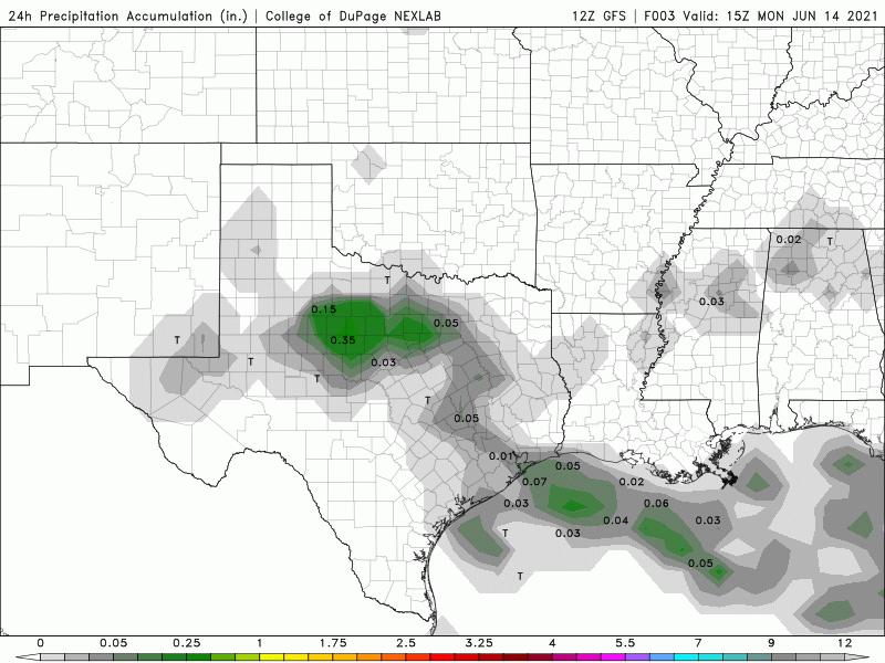
12Z GFS brings the highest rainfall totals back West a bit, splitting the difference between yesterday and today:
Posted on 6/14/21 at 12:57 pm to Twatsy37
Twat im gonna need you to calm down
Posted on 6/14/21 at 1:00 pm to Cosmo
quote:
Twat im gonna need you to calm down
12 year olds have problems handling their emotions.

Posted on 6/14/21 at 1:03 pm to LegendInMyMind
Up to 70%
quote:
Tropical Weather Outlook
NWS National Hurricane Center Miami FL
200 PM EDT Mon Jun 14 2021
For the North Atlantic...Caribbean Sea and the Gulf of Mexico:
1. Showers and thunderstorms continue over the Bay of Campeche in
association with a broad low pressure area. Gradual development of
this disturbance is possible during the next couple of days while it
meanders near the coast of Mexico. The system should begin to move
northward by midweek, and a tropical depression is likely to form
late in the week when the low moves across the central or
northwestern Gulf of Mexico. Regardless of development, heavy
rainfall is possible over portions of Central America and southern
Mexico during the next several days. Heavy rains could also begin
to impact portions of the northern Gulf Coast on Friday. Please
consult products from your local meteorological service for more
information.
* Formation chance through 48 hours...low...20 percent.
* Formation chance through 5 days...high...70 percent.

Posted on 6/14/21 at 1:14 pm to LegendInMyMind
quote:
12Z GFS brings the highest rainfall totals back West a bit
Interesting.
Been watching these runs for West/Central Alabama.
In a couple of months we might really need it, but right now we're already about +2" rainfall.
(2020 was the 5th-wettest recorded year in Birmingham.)
Posted on 6/14/21 at 1:18 pm to paperwasp
rds how is this going to affect my tee time at la tour on saturday?

Posted on 6/14/21 at 1:24 pm to The Boat
quote:
Hurricane Claudette dropped the hammer on Port O'Connor, Texas in 2003
Tropical Storm Claudette in 1979 was pretty nasty as well. Dropped 42 inches of rain over Alvin, Texas in one day. At the time it set the record for a 24 hour rainfall total in the U.S.

Posted on 6/14/21 at 1:28 pm to Cosmo
Will my 4:10 flight to Nashville out of MSY get cancelled on Friday ?!?!?!

 Page 17 of 72

Back to top