- My Forums
- Tiger Rant
- LSU Recruiting
- SEC Rant
- Saints Talk
- Pelicans Talk
- More Sports Board
- Fantasy Sports
- Golf Board
- Soccer Board
- O-T Lounge
- Tech Board
- Home/Garden Board
- Outdoor Board
- Health/Fitness Board
- Movie/TV Board
- Book Board
- Music Board
- Political Talk
- Money Talk
- Fark Board
- Gaming Board
- Travel Board
- Food/Drink Board
- Ticket Exchange
- TD Help Board
Customize My Forums- View All Forums
- Show Left Links
- Topic Sort Options
- Trending Topics
- Recent Topics
- Active Topics
Started By
Message
re: Tornado! Watch Issued for Most of Louisiana - Nocturnal Tornado Threat for Louisiana
Posted on 10/31/18 at 1:34 pm to NorthshoreTiger76

Posted on 10/31/18 at 1:34 pm to NorthshoreTiger76
quote:
Meh they always predict bad weather and nothing happens
Are you nuts. Last time we had this setup we had a tornado that barely missed Lakeview and took out NOE.
 2
2

Posted on 10/31/18 at 1:42 pm to t00f
If that is the day I’m thinking of they had several touchdown in south La. I know one in La Place and up near Convent we’re pretty strong ones.
Work made us go home at 10:30AM. I remember as I was driving home my radio and phone blew up with a warning alert of one supposedly near me. Scared the hell out of me
Work made us go home at 10:30AM. I remember as I was driving home my radio and phone blew up with a warning alert of one supposedly near me. Scared the hell out of me
This post was edited on 10/31/18 at 1:52 pm
Posted on 10/31/18 at 1:51 pm to rt3
Damnnnn :(
Wonder if Jeff will make it out?
Wonder if Jeff will make it out?
Posted on 10/31/18 at 1:55 pm to notiger1997
Yes I recall that.
What will make this different is it’ll most likely happen before it’s daylight which is pretty scary.
What will make this different is it’ll most likely happen before it’s daylight which is pretty scary.

Posted on 10/31/18 at 1:57 pm to Chad504boy
quote:loosely. Any point within X miles of the shaded area has that percent chance of seeing a tornado. I dont remember the exact mile distance.
is this like rain %? 10% of circle is a tornado?
Posted on 10/31/18 at 1:58 pm to Pedro
25 miles within a single point in the color area.
Hatch is for significant severe.
Hatch is for significant severe.
This post was edited on 10/31/18 at 2:29 pm
Posted on 10/31/18 at 2:08 pm to t00f
quote:
Are you nuts. Last time we had this setup we had a tornado that barely missed Lakeview and took out NOE.
Let's reminisce about February 7, 2017 shall we
YouTube - Fox 8 Storm Coverage Part 1 (River Parishes/Convent Tornado - Ends as NO East Tornado is about to touch down)
YouTube - Fox 8 Storm Coverage Part 2 (starts with the NO East tornado on the ground)
Posted on 10/31/18 at 2:27 pm to rt3

Mesoscale Discussion 1601
NWS Storm Prediction Center Norman OK
0214 PM CDT Wed Oct 31 2018
Areas affected...parts of east to eastern Texas and far western
Louisiana
Concerning...Severe potential...Watch possible
Valid 311914Z - 312145Z
Probability of Watch Issuance...60 percent
SUMMARY...Storms are likely to increase in coverage and intensity by
late afternoon across central into east-central Texas, continuing
into western Louisiana after 9-10 pm. Damaging winds will be
possible initially, with a couple tornadoes increasingly possible
through the night.
DISCUSSION...An axis of substantial moisture and instability
currently stretches from Deep South TX northward to an approaching
cold front. Lift is increasing across the region in association with
a leading shortwave trough, with an abrupt wind shift noted above
the surface at the DFX VWP. Lift is strongest where this feature
intersects the surface front, currently over central TX where a
cluster of elevated storms exists.
With time, storms should increase in intensity as they translate
southeastward. Severe wind is possible as storms become more linear
in a few hours. Veering winds above the surface will mitigate SRH
and tornado threat for western parts of the discussion area.
However, a tornado threat may eventually materialized over eastern
areas.
For southeastern TX into LA, early-day convection has left
relatively cool air across the Houston area where showers persist.
Area VWPs show marginally favorable wind profiles for supercells,
which should get better with time as both the low-level jet and
winds aloft increase. Here, effective SRH around 200-300 should
develop this evening. As a result, a few storms near the upper TX
coast toward southwest LA may become supercells, and a tornado
cannot be ruled out. In addition, a burst of new development may
occur immediately ahead of any approaching squall line from the
west, with tornado threat.
..Jewell/Thompson.. 10/31/2018
...Please see www.spc.noaa.gov for graphic product...
ATTN...WFO...LCH...SHV...HGX...FWD...CRP...EWX...
LAT...LON 27909677 28109731 28939769 29399780 30139795 30509783
30999724 31679630 32299555 32429471 32159399 31639361
31069329 30399313 29649332 29459427 29059493 28659554
28369617 28169637 27909677

Posted on 10/31/18 at 2:28 pm to rds dc
I'm waiting for peej prognostications. 
Posted on 10/31/18 at 2:28 pm to lsuman25
quote:
25 miles within a single point in the hatch area.
The hatch indicates higher end (EF2+) tornado possibilities, the colors are for 25 miles from a given point.
Posted on 10/31/18 at 2:30 pm to Duke
I edited it didn't want people to get confused.
Posted on 10/31/18 at 2:45 pm to Chad504boy
quote:
this like rain %? 10% of circle is a tornado?
It means 10% of the people in that circle will die
Posted on 10/31/18 at 2:45 pm to Duke
We were just informed of all of this. I hate bad weather. It's going to be a long night for me.
Posted on 10/31/18 at 2:48 pm to Tester1216
NWS SPC
?
Verified account
@NWSSPC
47s47 seconds ago
More
We are on the phone with local NWS offices across south-central and eastern Texas and Louisiana coordinating the timing and specific locations for a forthcoming watch. Watch should be issued shortly.
?
Verified account
@NWSSPC
47s47 seconds ago
More
We are on the phone with local NWS offices across south-central and eastern Texas and Louisiana coordinating the timing and specific locations for a forthcoming watch. Watch should be issued shortly.
Posted on 10/31/18 at 2:49 pm to lsuman25
quote:
We are on the phone with local NWS offices across south-central and eastern Texas and Louisiana coordinating the timing and specific locations for a forthcoming watch. Watch should be issued shortly.
I need to know the timing of this shite ASAP...

Posted on 10/31/18 at 2:50 pm to rds dc
quote:
moist axis
Tell me more...

Posted on 10/31/18 at 2:54 pm to Duke
When is this expected to be out of the BR area, around 9 or 10? Is it fast moving or will it linger?
Posted on 10/31/18 at 2:59 pm to tgrbaitn08
where do you live?
Posted on 10/31/18 at 3:02 pm to lsuman25
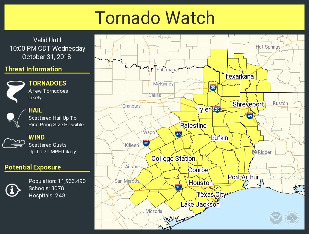
First Tornado watch of the day.

Posted on 10/31/18 at 3:02 pm to Paul Allen
I am pretty sure it’s supposed to be getting real in the north Houston area at about 10 so I would think a few hours later in BR. Now this was from last nights forecast so this may have changed.

 Page 2 of 26

Popular
Back to top