- My Forums
- Tiger Rant
- LSU Recruiting
- SEC Rant
- Saints Talk
- Pelicans Talk
- More Sports Board
- Fantasy Sports
- Golf Board
- Soccer Board
- O-T Lounge
- Tech Board
- Home/Garden Board
- Outdoor Board
- Health/Fitness Board
- Movie/TV Board
- Book Board
- Music Board
- Political Talk
- Money Talk
- Fark Board
- Gaming Board
- Travel Board
- Food/Drink Board
- Ticket Exchange
- TD Help Board
Customize My Forums- View All Forums
- Show Left Links
- Topic Sort Options
- Trending Topics
- Recent Topics
- Active Topics
Started By
Message
re: Tornado watch for all of SE LA and most of Miss. until 3 AM
Posted on 11/17/15 at 10:42 pm to DingLeeBerry
Posted on 11/17/15 at 10:42 pm to DingLeeBerry
quote:
by DingLeeBerryPower has been out in Madison for over an hour. Wind still blowing like crazy.
haven't lost power yet in my part of town...
 1
1

Posted on 11/17/15 at 10:44 pm to Mullet Flap
Any weather reports from B.R.
Posted on 11/17/15 at 10:45 pm to Spankum
Still no power here and no estimate on when it will be restored due to extensive outages per Entergy .

Posted on 11/17/15 at 10:49 pm to LSU5508
Very windy, heavy rain currently, and some thunder and lightning
Posted on 11/17/15 at 10:49 pm to LSU5508
BR Especially Zachary look to be getting battered right now
Be careful Jackson OT'ers!
Be careful Jackson OT'ers!
This post was edited on 11/17/15 at 10:58 pm
Posted on 11/17/15 at 10:54 pm to DingLeeBerry
quote:
Still no power here and no estimate on when it will be restored due to extensive outages per Entergy .
I'd guess that they probably are not even going to get out in it to begin working until this line of weather passes. I am just keeping my fingers crossed that mine stays on.
Posted on 11/17/15 at 10:57 pm to Spankum
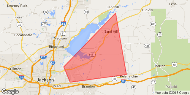
Just issued a tornado warning for central Rankin county. Fannin, Goshen Springs, etc.

Posted on 11/17/15 at 10:58 pm to Spankum
I flew through it about 3 hours ago right over Alexandria. That was the opening that ATC identified (original flight plan was ATL down to the gulf under it and fly direct to Corpus Christi on into IAH) ATC gave us a last minute redirect and said it would be tolerable.
The plane was jumping around pretty good, lots of vertical wind. That was not a storm id want to mess with.
The plane was jumping around pretty good, lots of vertical wind. That was not a storm id want to mess with.
Posted on 11/17/15 at 11:03 pm to DingLeeBerry
If you look at the Entergy outage map, it is really not showing all that much power to be out in this area...just a few neighborhoods, really.
Posted on 11/17/15 at 11:06 pm to DingLeeBerry
quote:
WE HAVE A CONFIRMED TORNADO in Rankin County near Castlewoods...Spillway and Hwy 25. @WLBT @Fox40News
quote:
A Confirmed Tornado Was Located Over Castlewoods... Moving Northeast At 30 MPH. Hazard... Damaging Tornado. Source... Radar Confirmed Tornado. Impact... Flying Debris Will Be Dangerous To Those Caught Without Shelter. Mobile Homes Will Be Damaged Or Destroyed. Damage To Roofs... Windows And Vehicles Will Occur. Tree Damage Is Likely. This Tornado Will Be Near... Fannin Around 1115 PM CST. Goshen Springs Around 1125 PM CST. Pisgah Around 1130 PM CST. Tornado... Observed Hail... <.75in
This post was edited on 11/17/15 at 11:08 pm

Posted on 11/17/15 at 11:06 pm to Spankum
Tornado supposedly on top of us. Got family in tub
Posted on 11/17/15 at 11:07 pm to SabiDojo
quote:
Tornado supposedly on top of us. Got family in tub
hang in there sabi...
Posted on 11/17/15 at 11:07 pm to Spankum
Thanks, brah.
Posted on 11/17/15 at 11:14 pm to SabiDojo
My power goes out with a hard wind. I'm expecting to be waking up to a hot morning here in New Orleans.
Posted on 11/17/15 at 11:15 pm to Spankum
quote:
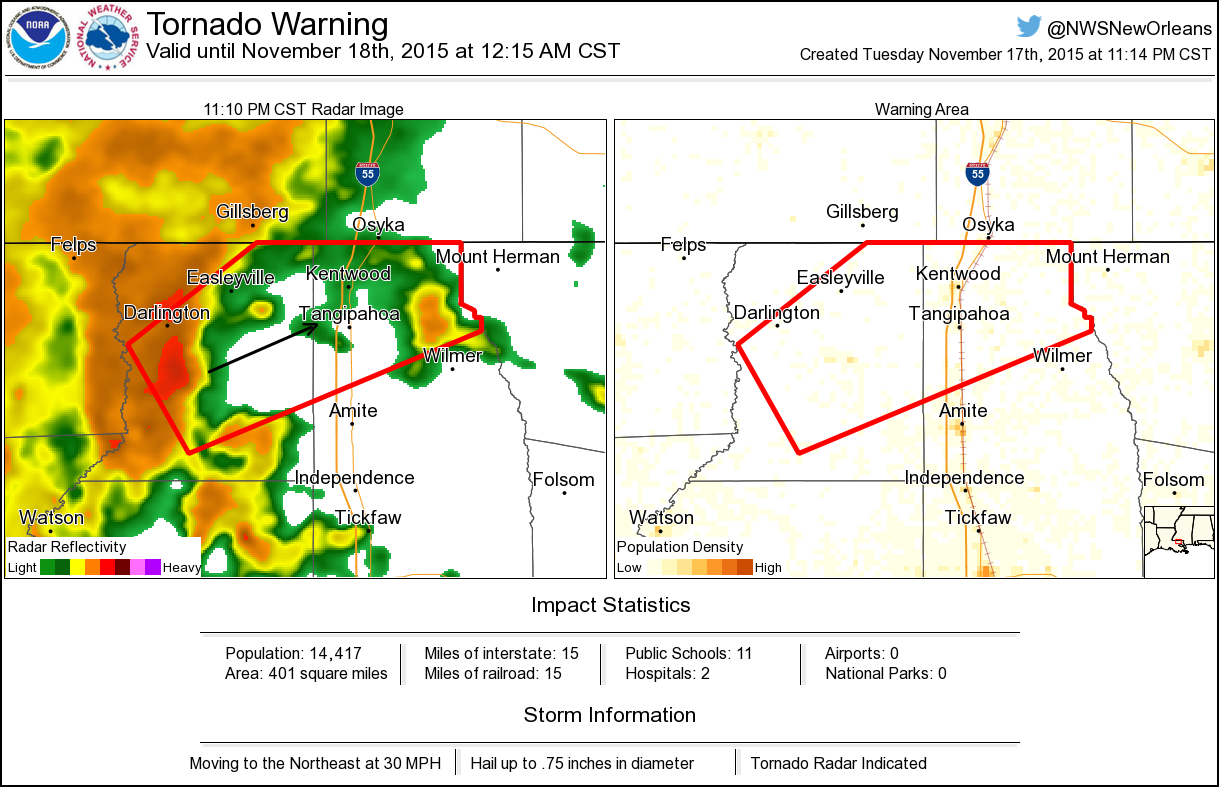
Tornado Warning including Kentwood LA, Easleyville LA, Darlington LA until 12:15 AM CST
Posted on 11/17/15 at 11:16 pm to NorthEndZone

Posted on 11/17/15 at 11:20 pm to bpinson
Coming down harder than ever in BR

Posted on 11/17/15 at 11:23 pm to jimbeam
Alexandra Cranford Verified account
?@acranfordwwl
If you're in the Kentwood, Fluker, Bolivar areas in Tangipahoa, take cover. Storm w/ rotation heading NE @ 30mph.
This post was edited on 11/17/15 at 11:26 pm
Posted on 11/17/15 at 11:34 pm to jlu03
Livingston Bros need to keep an ear out. Seeing a broad rotation in South East BR starting to tighten up as it heads toward Livingston.
It's most likely going to be nothing, but heads up nonetheless.
It's most likely going to be nothing, but heads up nonetheless.
Posted on 11/17/15 at 11:35 pm to Duke
I think we're okay.
Everybody be safe
Everybody be safe

 Page 3 of 4

Popular
Back to top