- My Forums
- Tiger Rant
- LSU Recruiting
- SEC Rant
- Saints Talk
- Pelicans Talk
- More Sports Board
- Coaching Changes
- Fantasy Sports
- Golf Board
- Soccer Board
- O-T Lounge
- Tech Board
- Home/Garden Board
- Outdoor Board
- Health/Fitness Board
- Movie/TV Board
- Book Board
- Music Board
- Political Talk
- Money Talk
- Fark Board
- Gaming Board
- Travel Board
- Food/Drink Board
- Ticket Exchange
- TD Help Board
Customize My Forums- View All Forums
- Show Left Links
- Topic Sort Options
- Trending Topics
- Recent Topics
- Active Topics
Started By
Message

 1
1

Posted on 4/2/17 at 1:44 am to Pedro
this is setting up to be a damn fun day
This post was edited on 4/2/17 at 1:45 am
Posted on 4/2/17 at 1:54 am to Pedro
quote:
MLCAPE ranging from 2000-3000 J/kg
holy frick
That's about normal for this time of year, and that's assuming the air doesn't get contaminated early in the morning.

Posted on 4/2/17 at 1:54 am to Woopigsooie20
Along the coast usually 1000 J/kg will do it.
Posted on 4/2/17 at 1:57 am to GEAUXmedic
Yeah, usually a little extra turning of the winds with the ocean fronts and sea breezes.
Posted on 4/2/17 at 2:27 am to Woopigsooie20
So what does all this mean? For SWLA in particular
Posted on 4/2/17 at 2:41 am to Chuckd
quote:
So what does all this mean? For SWLA in particular
It means have a plan in place for you and your family tomorrow in the event of severe weather. Try to get things done early so you can be home, in sturdy shelter by afternoon, pay attention to the weather and have a way to receive timely warnings and alerts such as a weather radio or app.
Posted on 4/2/17 at 3:12 am to GEAUXmedic
What about Monroe area??
Posted on 4/2/17 at 3:17 am to GEAUXmedic
Thanks. What are we talking here? Tornados?
Posted on 4/2/17 at 3:24 am to Chuckd
quote:
Thanks. What are we talking here? Tornados?
Hail, Damaging Wind, Tornadoes, Flooding.
Posted on 4/2/17 at 3:25 am to CheniereTiger108
quote:
What about Monroe area??
In the bullseye as of right now. You're under a moderate risk which is pretty damn high.
Posted on 4/2/17 at 4:06 am to GEAUXmedic
Latest NAM blows up over southeast louisiana compared to the last two runs. It's almost time to start nowcasting though.
Latest NAM shows a more organized system with more discrete cells ahead of it.
Last 3 runs in .gif form at 3AM Monday.


Latest NAM shows a more organized system with more discrete cells ahead of it.
Last 3 runs in .gif form at 3AM Monday.
This post was edited on 4/2/17 at 4:07 am
Posted on 4/2/17 at 4:11 am to GEAUXmedic
Latest NAM:


Posted on 4/2/17 at 4:48 am to GEAUXmedic
quote:
National Weather Service New Orleans LA
445 AM CDT Sun Apr 2 2017
...Wind Advisory...
.STRONG SOUTHEASTERLY WINDS WILL DEVELOP TODAY AND INCREASE
SUBSTANTIALLY OVERNIGHT AS A SURFACE LOW DEEPENS OVER NORTHEAST
TEXAS AND EASTERN OKLAHOMA. THE PRESSURE GRADIENT WILL BE SUCH
THAT SOUTHEAST WINDS REACH 25 TO 30 KNOTS WITH HIGHER GUSTS. THIS
WILL CAUSE TIDES TO INCREASE ON SOUTH TO SOUTHEAST FACING SHORES.
LAZ040-046>050-056>070-072-MSZ080>082-021745-
/O.NEW.KLIX.WI.Y.0004.170403T0000Z-170403T1500Z/
St. Tammany-Iberville-West Baton Rouge-East Baton Rouge-Ascension-
Livingston-Assumption-St. James-St. John The Baptist-
Upper Lafourche-St. Charles-Upper Jefferson-Orleans-
Upper Plaquemines-Upper St. Bernard-Upper Terrebonne-
Lower Terrebonne-Lower Lafourche-Lower Jefferson-
Lower Plaquemines-Lower St. Bernard-Southern Tangipahoa-Hancock-
Harrison-Jackson-
Including the cities of Slidell, Mandeville, Covington, Lacombe,
Bayou Sorrel, Plaquemine, White Castle, Port Allen, Addis,
Brusly, Baton Rouge, Gonzales, Donaldsonville, Prairieville,
Denham Springs, Watson, Walker, Pierre Part, Labadieville,
Paincourtville, Convent, Lutcher, Gramercy, Laplace, Reserve,
Thibodaux, Raceland, Larose, Destrehan, Norco, Metairie, Kenner,
East New Orleans, New Orleans, Belle Chasse, Chalmette, Violet,
Houma, Bayou Cane, Chauvin, Cocodrie, Dulac, Montegut, Galliano,
Cut Off, Golden Meadow, Leeville, Buras, Pointe A La Hache,
Port Sulphur, Boothville, Venice, Empire, Myrtle Grove,
Yscloskey, Hammond, Robert, Ponchatoula, Bay St. Louis, Waveland,
Diamondhead, Gulfport, Pascagoula, Ocean Springs, Moss Point,
Gautier, and St. Martin
445 AM CDT Sun Apr 2 2017
...WIND ADVISORY IN EFFECT FROM 7 PM THIS EVENING TO 10 AM CDT
MONDAY...
The National Weather Service in New Orleans has issued a Wind
Advisory, which is in effect from 7 PM this evening to 10 AM CDT
Monday.
* TIMING...Winds will peak between around 10 PM to 3 AM tonight.
* WINDS...25 to 30 mph with gusts up to 40 mph.
* IMPACTS...Difficult driving conditions for high profile
vehicles especially on east-west roadways and on bridges and
overpasses. Loose lawn objects along with trash cans will be
blown around.
PRECAUTIONARY/PREPAREDNESS ACTIONS...
A Wind Advisory means that winds of 26 to 39 mph are expected.
Winds this strong can make driving difficult...especially for
high profile vehicles. Use extra caution.
quote:
COASTAL HAZARD MESSAGE
NATIONAL WEATHER SERVICE NEW ORLEANS LA
441 AM CDT SUN APR 2 2017
...COASTAL FLOODING...
.STRONG SOUTHEASTERLY WINDS WILL DEVELOP TODAY AND INCREASE
SUBSTANTIALLY OVERNIGHT AS A SURFACE LOW DEEPENS OVER NORTHEAST
TEXAS AND EASTERN OKLAHOMA. THE PRESSURE GRADIENT WILL BE SUCH
THAT SOUTHEAST WINDS REACH 25 TO 30 KNOTS WITH HIGHER GUSTS. THIS
WILL CAUSE TIDES TO INCREASE ON SOUTH TO SOUTHEAST FACING SHORES.
LAZ040-050-058-062-064-066>070-072-MSZ080>082-021745-
/O.NEW.KLIX.CF.Y.0003.170402T1800Z-170404T0000Z/
ST. TAMMANY-LIVINGSTON-ST. JOHN THE BAPTIST-ORLEANS-
UPPER ST. BERNARD-LOWER TERREBONNE-LOWER LAFOURCHE-
LOWER JEFFERSON-LOWER PLAQUEMINES-LOWER ST. BERNARD-
SOUTHERN TANGIPAHOA-HANCOCK-HARRISON-JACKSON-
441 AM CDT SUN APR 2 2017
...COASTAL FLOOD ADVISORY IN EFFECT FROM 1 PM THIS AFTERNOON TO
7 PM CDT MONDAY...
THE NATIONAL WEATHER SERVICE IN NEW ORLEANS HAS ISSUED A COASTAL
FLOOD ADVISORY, WHICH IS IN EFFECT FROM 1 PM THIS AFTERNOON TO
7 PM CDT MONDAY.
* COASTAL FLOODING...TIDES 1 TO 2 FEET ABOVE NORMAL.
* TIMING...PEAK TIDES WILL BE IN THE EARLY AFTERNOON HOURS TODAY
AND TOMORROW.
* IMPACTS...MINOR FLOODING OF LOW LYING AREAS AND ACCESS ROADS
NEAR TIDAL LAKES...BAYS AND INLETS AS WELL AS THE OPEN COAST
OUTSIDE THE HURRICANE PROTECTION LEVEE SYSTEMS.
PRECAUTIONARY/PREPAREDNESS ACTIONS...
A COASTAL FLOOD ADVISORY INDICATES THAT ONSHORE WINDS AND TIDES
WILL COMBINE TO GENERATE FLOODING OF LOW AREAS ALONG THE SHORE.
This post was edited on 4/2/17 at 4:49 am
Posted on 4/2/17 at 5:32 am to GEAUXmedic
A morning tornado watch will be issued soon for parts of Texas

Posted on 4/2/17 at 5:59 am to rds dc
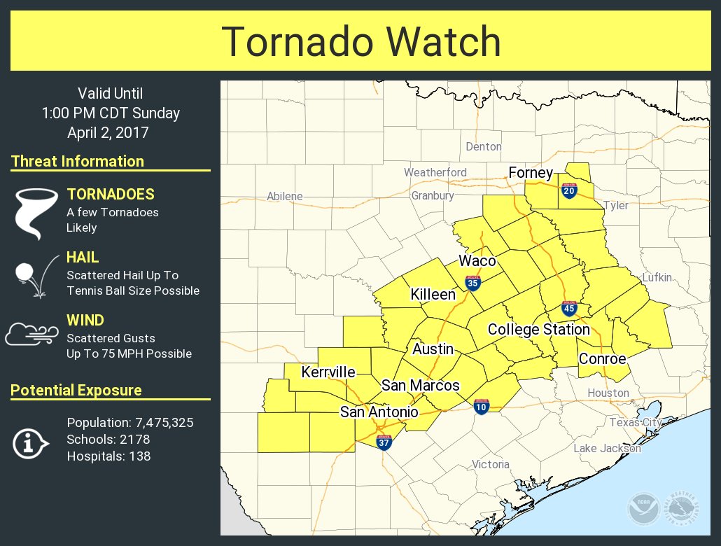
URGENT - IMMEDIATE BROADCAST REQUESTED
Tornado Watch Number 108
NWS Storm Prediction Center Norman OK
555 AM CDT Sun Apr 2 2017
The NWS Storm Prediction Center has issued a
* Tornado Watch for portions of
Parts of central and east Texas
* Effective this Sunday morning and afternoon from 555 AM until
100 PM CDT.
* Primary threats include...
A few tornadoes likely
Scattered damaging winds and isolated significant gusts to 75
mph possible
Scattered large hail and isolated very large hail events to 2.5
inches in diameter possible
SUMMARY...A large cluster of thunderstorms that has persisted
overnight west of San Antonio will likely begin to organize into
more of a bowing line with time, with an attendant increase in the
damaging wind risk. Embedded circulations will also pose a tornado
risk. Ahead of the line of storms, more isolated cells now forming
in the Houston to Austin corridor will shift northward with time,
and some could become supercells capable of producing a few
tornadoes later this morning. Large hail will also be possible with
the stronger storms.
The tornado watch area is approximately along and 65 statute miles
north and south of a line from 55 miles west of Hondo TX to 40 miles
south southeast of Tyler TX. For a complete depiction of the watch
see the associated watch outline update (WOUS64 KWNS WOU8).
PRECAUTIONARY/PREPAREDNESS ACTIONS...
REMEMBER...A Tornado Watch means conditions are favorable for
tornadoes and severe thunderstorms in and close to the watch
area. Persons in these areas should be on the lookout for
threatening weather conditions and listen for later statements
and possible warnings.
This post was edited on 4/2/17 at 6:00 am
Posted on 4/2/17 at 6:00 am to rds dc
The latest HRRR appears to limit the threat of long lived individual supercell thunderstorms capable of producing violent tornadoes. There is an ongoing MCS in Texas and it looks like it maintains through most of the day with cells forming out in front quickly growing upscale into clusters. The big question is what happens across S. Louisiana this evening w/ the biggest threat appearing to be north of I10.

Posted on 4/2/17 at 6:02 am to rds dc
I haven't been a fan of the HRRR lately, when compared to real time radar. It either overdoes it or underplays it.
Posted on 4/2/17 at 6:12 am to GEAUXmedic
quote:
I haven't been a fan of the HRRR lately, when compared to real time radar. It either overdoes it or underplays it.
It certainly has issues and can be too quick to initiate convection but a lot of the time it does better than the 3k NAM. A large quick moving MCS has always been one of the factors that could potentially keep today in check.
Posted on 4/2/17 at 6:13 am to rds dc
quote:
It certainly has issues and can be too quick to initiate convection but a lot of the time it does better than the 3k NAM. A large quick moving MCS has always been one of the factors that could potentially keep today in check.
3k NAM is even worse, I look to it for a general idea and trending though.
This post was edited on 4/2/17 at 6:14 am

 Page 7 of 52

Popular
Back to top