- My Forums
- Tiger Rant
- LSU Recruiting
- SEC Rant
- Saints Talk
- Pelicans Talk
- More Sports Board
- Fantasy Sports
- Golf Board
- Soccer Board
- O-T Lounge
- Tech Board
- Home/Garden Board
- Outdoor Board
- Health/Fitness Board
- Movie/TV Board
- Book Board
- Music Board
- Political Talk
- Money Talk
- Fark Board
- Gaming Board
- Travel Board
- Food/Drink Board
- Ticket Exchange
- TD Help Board
Customize My Forums- View All Forums
- Show Left Links
- Topic Sort Options
- Trending Topics
- Recent Topics
- Active Topics
Started By
Message
re: Tornado! Threat Continues Overnight then Shifts East Tomorrow
Posted on 4/2/17 at 1:07 pm to DVinBR
Posted on 4/2/17 at 1:07 pm to DVinBR
quote:
anyone know what the "SIG SEVERE" area means?
Pretty sure it means significant severe risk, aka:
quote:
The SPC further defines significant severe thunderstorms as any storm that produce one or more of the following elements:
A tornado that produces EF2 or greater damage.
Wind speeds of 75 mph (65 knots) or greater.
Hail 2 inch in diameter or larger.
 1
1


Posted on 4/2/17 at 1:08 pm to slackster
Torando warning Southwest caddo parish. Great

Posted on 4/2/17 at 1:09 pm to slackster
Keep us updated on that warned storm east of Carthage. I'm out at lunch but if I'm looking at the right area in radar, that could be moving into Shreveport in a bit.
Posted on 4/2/17 at 1:11 pm to rds dc
While not tornadic, the storm NE of Monroe is probably dropping fairly significant hail:

Posted on 4/2/17 at 1:13 pm to Lsuhoohoo
think Weather Channel said they're going back to storm coverage at either the bottom of the hour or 2 PM
Posted on 4/2/17 at 1:14 pm to LSURoss
What app is that?
Posted on 4/2/17 at 1:16 pm to slackster
While still broad, there is some circulation with that cluster near Oakdale.


Posted on 4/2/17 at 1:16 pm to 9Fiddy
quote:
What app is that?
RadarScope
Posted on 4/2/17 at 1:17 pm to 9Fiddy
RadarScope $10/yr
Posted on 4/2/17 at 1:18 pm to slackster
sun is now out in west baton rouge parish 
Posted on 4/2/17 at 1:18 pm to slackster
Definitely looking like it could become a dominant storm soon.
Posted on 4/2/17 at 1:18 pm to rt3
this one's mine
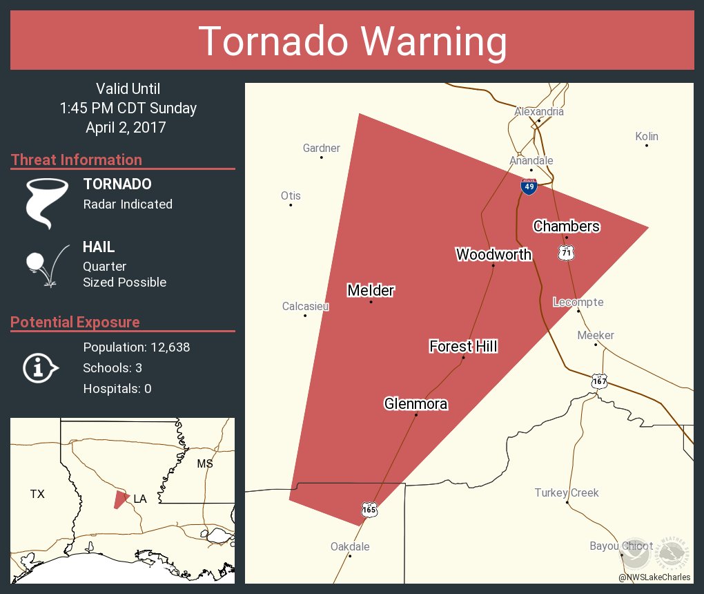
quote:
The National Weather Service in Lake Charles has issued a
* Tornado Warning for... South central Rapides Parish in central Louisiana... Northern Allen Parish in southwestern Louisiana...
* Until 145 PM CDT
* At 117 PM CDT, a severe thunderstorm capable of producing a tornado was located near Glenmora, moving northeast at 50 mph. HAZARD... Tornado and quarter size hail. SOURCE... Radar indicated rotation. IMPACT... Flying debris will be dangerous to those caught without shelter. Mobile homes will be damaged or destroyed. Damage to roofs, windows, and vehicles will occur. Tree damage is likely.
* This dangerous storm will be near... Glenmora around 120 PM CDT. Elmer around 130 PM CDT. Alexandria around 145 PM CDT. Other locations impacted by this tornadic thunderstorm include Woodworth, Forest Hill and Mcnary. PRECAUTIONARY/PREPAREDNESS ACTIONS... TAKE COVER NOW! Move to a basement or an interior room on the lowest floor of a sturdy building. Avoid windows. If you are outdoors, in a mobile home, or in a vehicle, move to the closest substantial shelter and protect yourself from flying debris.
Posted on 4/2/17 at 1:19 pm to slackster
Annnnnd now it's warned:
Posted on 4/2/17 at 1:19 pm to Woopigsooie20
Tornado Warning on the Oakdale storm now
Posted on 4/2/17 at 1:20 pm to slackster
New warning from NWS Shreveport:

Posted on 4/2/17 at 1:21 pm to Woopigsooie20
Rotation near Nacogdoches looks hefty at the moment.
Posted on 4/2/17 at 1:22 pm to slackster
quote:
Annnnnd now it's warned
It has undergone some mergers and the area to the SE is now pretty clear of convection. If this makes a right turn away from the other convection...
Posted on 4/2/17 at 1:25 pm to LSURoss
Western Desoto Parish can't get a break - one warning after another.
Posted on 4/2/17 at 1:26 pm to slackster
Outside of the obviously warned cells, these are also promising/troublesome, depending on your outlook:


Posted on 4/2/17 at 1:27 pm to Woopigsooie20
Yeah, the rotation east of Nacogdoches looks good.

 Page 20 of 52

Popular
Back to top