- My Forums
- Tiger Rant
- LSU Recruiting
- SEC Rant
- Saints Talk
- Pelicans Talk
- More Sports Board
- Fantasy Sports
- Golf Board
- Soccer Board
- O-T Lounge
- Tech Board
- Home/Garden Board
- Outdoor Board
- Health/Fitness Board
- Movie/TV Board
- Book Board
- Music Board
- Political Talk
- Money Talk
- Fark Board
- Gaming Board
- Travel Board
- Food/Drink Board
- Ticket Exchange
- TD Help Board
Customize My Forums- View All Forums
- Show Left Links
- Topic Sort Options
- Trending Topics
- Recent Topics
- Active Topics
Started By
Message
re: Tornado! Threat Continues Overnight then Shifts East Tomorrow
Posted on 4/2/17 at 1:45 pm to GeauxMatt624
Posted on 4/2/17 at 1:45 pm to GeauxMatt624
quote:
Any update on its location?
Approximately here:

 4
4

Posted on 4/2/17 at 1:45 pm to slackster
Damn that looks bad for Alexandria
Posted on 4/2/17 at 1:45 pm to slackster
Debris ball?
Posted on 4/2/17 at 1:46 pm to GEAUXmedic
Jesus. Be safe out there everybody.
Posted on 4/2/17 at 1:46 pm to GEAUXmedic
quote:
Oh my god that track goes straight through Alexandria.
would keep it to my west
Posted on 4/2/17 at 1:47 pm to GEAUXmedic
quote:
Oh my god that track goes straight through Alexandria.
Backside is getting heavy looking, maybe the RFD will choke it out and it will have to cycle, getting it past Alexandria out into a more rural area....
Posted on 4/2/17 at 1:47 pm to slackster
quote:
Approximately here:
well crap... right on line
Posted on 4/2/17 at 1:47 pm to slackster
Might be getting choked off - let's hope:


Posted on 4/2/17 at 1:48 pm to slackster
Went slightly to the east
Posted on 4/2/17 at 1:49 pm to slackster
Storm to the NW of Alexandria might be an issue going forward as well.


Posted on 4/2/17 at 1:50 pm to slackster
High risk, tornadoes on the ground, and The Weather Channel has a show about supernatural events on right now.
Posted on 4/2/17 at 1:51 pm to Roll Tide Ravens
quote:
High risk, tornadoes on the ground, and The Weather Channel has a show about supernatural events on right now.
they keep breaking in with updates and say they're going wall to wall at the top of the hour
Posted on 4/2/17 at 1:51 pm to Chatagnier
Rotation still visible. 13 miles from Alexandria.

Posted on 4/2/17 at 1:52 pm to slackster
quote:
Rotation still visible. 13 miles from Alexandria.
please wash out... please wash out
Posted on 4/2/17 at 1:52 pm to slackster
quote:
Rotation still visible. 13 miles from Alexandria.
Might be about to ramp up again, hail spike showing up on last scan
Posted on 4/2/17 at 1:53 pm to rt3
PDS TORNADO WATCH:
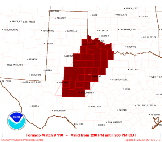
quote:
URGENT - IMMEDIATE BROADCAST REQUESTED
Tornado Watch Number 110
NWS Storm Prediction Center Norman OK
135 PM CDT Sun Apr 2 2017
The NWS Storm Prediction Center has issued a
* Tornado Watch for portions of
Central and Northern Louisiana
West-central Mississippi
East Texas
* Effective this Sunday afternoon and evening from 135 PM until
900 PM CDT.
...THIS IS A PARTICULARLY DANGEROUS SITUATION...
* Primary threats include...
Numerous tornadoes and several intense tornadoes expected
Widespread large hail and scattered very large hail events to 3
inches in diameter likely
Widespread damaging wind gusts to 70 mph likely
SUMMARY...A dangerous combination of parameters suggests that
tornadoes will occur over parts of east TX, northern and central LA,
and eastern MS this afternoon and evening. Strong tornadoes are a
concern.
The tornado watch area is approximately along and 55 statute miles
north and south of a line from 85 miles west of Fort Polk LA to 65
miles northeast of Natchez MS. For a complete depiction of the watch
see the associated watch outline update (WOUS64 KWNS WOU0).
PRECAUTIONARY/PREPAREDNESS ACTIONS...
REMEMBER...A Tornado Watch means conditions are favorable for
tornadoes and severe thunderstorms in and close to the watch
area. Persons in these areas should be on the lookout for
threatening weather conditions and listen for later statements
and possible warnings.
Posted on 4/2/17 at 1:53 pm to Roll Tide Ravens
quote:
High risk, tornadoes on the ground, and The Weather Channel has a show about supernatural events on right now.
TWC crossed the line into absolute suckage years ago.
Posted on 4/2/17 at 1:54 pm to rt3
quote:
they keep breaking in with updates and say they're going wall to wall at the top of the hour
Still a bad look, current conditions warrant them already doing wall-to-wall coverage.
Posted on 4/2/17 at 1:54 pm to Arkla Missy
that 2nd cell west of Alexandria is now tornado warned
Posted on 4/2/17 at 1:55 pm to Roll Tide Ravens
May have lifted but still
Dangerous. NWS. Is says radar indicated only. Don't take a chance though
Dangerous. NWS. Is says radar indicated only. Don't take a chance though

 Page 22 of 52

Popular
Back to top