- My Forums
- Tiger Rant
- LSU Recruiting
- SEC Rant
- Saints Talk
- Pelicans Talk
- More Sports Board
- Coaching Changes
- Fantasy Sports
- Golf Board
- Soccer Board
- O-T Lounge
- Tech Board
- Home/Garden Board
- Outdoor Board
- Health/Fitness Board
- Movie/TV Board
- Book Board
- Music Board
- Political Talk
- Money Talk
- Fark Board
- Gaming Board
- Travel Board
- Food/Drink Board
- Ticket Exchange
- TD Help Board
Customize My Forums- View All Forums
- Show Left Links
- Topic Sort Options
- Trending Topics
- Recent Topics
- Active Topics
Started By
Message
 1
1

Posted on 12/11/21 at 11:31 am to rt3
He sure did he’s going over all the data and you can tell by his voice that it’s simply Elite stuff. I guess NWS will send people to look at the area where it peaked to get some evidence of how powerful it was. I know Mayfield and in that area was hard hit but to investigate the area of damage where the data peaked would probably be wild to see.
Posted on 12/11/21 at 11:32 am to rt3
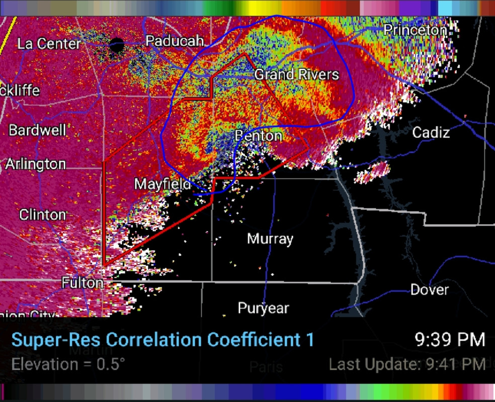
I know there are some here who won't understand what they are seeing, but when that storm was over Mayfield last night it did something that is very rare, probably moreso than anything else it can claim.
When you see a storm on radar that has large hail, it can show what is called a Three Body Scatter Spike, or a "hail spike".
The definition of a TBSS is:
Now, that isn't the only time you can see a TBSS on radar. Very rarely lofted debris in just the right part of the storm will cause the same type spike. It isn't hail, but debris.
I'd bet 8/10 mets or enthusiasts who regularly watch radar have never seen this happen live. Last night, in Mayfield, it happened. And it wasn't just a small blip that lasted a scan and went away, but it was a monster TBSS. I downloaded the gif from RadarScope right after it happened.

The spike shows up as soon as it hits the town of Mayfield and remains for multiple radar scans through the town.
This particular point of this storm's lifespan, as tragic as it is, will help future storm tracking more than most people know. It isn't just because of the spike, the debris data gathered will prove invaluable.
This storm, from its start to its merciful finish, will be studied for years to come.
When you see a storm on radar that has large hail, it can show what is called a Three Body Scatter Spike, or a "hail spike".
The definition of a TBSS is:
quote:
An area of reflectivity extending away from the radar immediately behind a thunderstorm with extremely large hail. In an area of large hail, radiation from the radar can bounce from hailstone to hailstone before being reflected back to the radar. The time delay between the backscattered radiation from the storm and the bounced and scattered radiation from the large hail causes the reflectivity from the hail to appear to come from a farther range than the actual storm.
Now, that isn't the only time you can see a TBSS on radar. Very rarely lofted debris in just the right part of the storm will cause the same type spike. It isn't hail, but debris.
I'd bet 8/10 mets or enthusiasts who regularly watch radar have never seen this happen live. Last night, in Mayfield, it happened. And it wasn't just a small blip that lasted a scan and went away, but it was a monster TBSS. I downloaded the gif from RadarScope right after it happened.
The spike shows up as soon as it hits the town of Mayfield and remains for multiple radar scans through the town.
This particular point of this storm's lifespan, as tragic as it is, will help future storm tracking more than most people know. It isn't just because of the spike, the debris data gathered will prove invaluable.
This storm, from its start to its merciful finish, will be studied for years to come.
Posted on 12/11/21 at 11:33 am to 4EvEr Bo REIN
They'll probably have to use radar data to find when it really peaked. It could have been at its most violent somewhere very rural and only get an EF3 there, because rating is based on damage.
So the radar data will tell a better story than on the ground surveys either.
So the radar data will tell a better story than on the ground surveys either.
Posted on 12/11/21 at 11:34 am to pioneerbasketball
quote:
This.
Weather channel didnt come back live to 5am Central.
And you can't bill yourself as "America's most trusted news source" like TWC does and then abandon your post right when there's a huge breaking situation in your field
This post was edited on 12/11/21 at 11:36 am
Posted on 12/11/21 at 11:34 am to Duke
quote:
This one will get studied to death, thats for sure.
It deserves it. I've never tracked a storm on radar that did all of what this storm did.
Posted on 12/11/21 at 11:35 am to LegendInMyMind
quote:
I'd bet 8/10 mets or enthusiasts who regularly watch radar have never seen this happen live.
I saw practically all of the best radar mets I know of say they've never seen it before.
Posted on 12/11/21 at 11:37 am to Duke
quote:
I saw practically all of the best radar mets I know of say they've never seen it before.
What blows my mind, and probably everyone else's, is the length of time it was there.
Posted on 12/11/21 at 11:38 am to Duke
quote:
I saw practically all of the best radar mets I know of say they've never seen it before.
Considering we may have watched the longest singular tornado in American history last night... I can guarantee no one has seen anything like we saw last night
This post was edited on 12/11/21 at 11:48 am

Posted on 12/11/21 at 11:44 am to LegendInMyMind
quote:
I know there are some here who won't understand what they are seeing, but when that storm was over Mayfield last night it did something that is very rare, probably moreso than anything else it can claim.
Man great post. Thanks.
Been seeing this term all over and couldn't find a clear layman explanation. Hope something positive comes from it.

Posted on 12/11/21 at 11:46 am to Impotent Waffle
quote:
100 people dead at the Candle factory. How terrible.
Where are you seeing this?
Posted on 12/11/21 at 11:46 am to LegendInMyMind
At least here, which is outside of Tuscaloosa, we have two times of the year that you need to really pay attention to the weather. Typically in December (occasionally late November through early January) and mid/late March through May. Obviously these coincide with the times of the year when we are either coming into or leaving our window of cold air.
It was really warm back in December 2000 when a tornado hit here, and snowed the next day. Most people know to watch out when it is either unseasonably warm or cold during those times.
What are your options to get away from it? Everywhere has something or some type of a natural disaster. Hurricanes, blizzards, tornadoes, wildfires, dust storms, extreme heat/cold, etc. It is a part of nature, and you either deal with it or move somewhere where you can deal with what they have. I've had several people ask me whey do I continue to live where you see a lot of tornadoes, and I ask them why do they live where they have wildfires/ice storms/etc. It is what it is.

Posted on 12/11/21 at 11:50 am to okietiger
LINK drone footage of Monette nursing home this morining. Those poor residents. Cannot imagine.
This post was edited on 12/11/21 at 11:54 am
Posted on 12/11/21 at 11:50 am to Duke
Could, you, Duke, or one of the other weather guys explain "gate to gate" velocity?
They were goin bonkers over >300mph speed.
They were goin bonkers over >300mph speed.
Posted on 12/11/21 at 11:51 am to Duke
This is the first frame after the spike went away. That whole part I circled is a debris field. A couple of frames, a matter of minutes, and that much debris had been cycled through and out of the updraft.
I hypothesized on a storm back in the early Fall that what we were seeing in a broad debris fallout like that was primarily dry leaves and vegetation that was among the lightest and more easily lofted debris. Alot of that, of course, is still the lightest debris, but most of it is man-made. The dry leaves and vegetation were long gone by yesterday. They were wet and decaying on the ground. There's some of that there, I'm sure, but it doesn't account for the majority, at least in my opinion.
I hypothesized on a storm back in the early Fall that what we were seeing in a broad debris fallout like that was primarily dry leaves and vegetation that was among the lightest and more easily lofted debris. Alot of that, of course, is still the lightest debris, but most of it is man-made. The dry leaves and vegetation were long gone by yesterday. They were wet and decaying on the ground. There's some of that there, I'm sure, but it doesn't account for the majority, at least in my opinion.

Posted on 12/11/21 at 11:53 am to Taxing Authority
Mane that is awful. Those elderly folks had to scared out their damn minds and felt so incredibly helpless.
Damn you, Mother Nature
Damn you, Mother Nature

Posted on 12/11/21 at 11:53 am to pioneerbasketball
quote:
Weather channel didnt come back live to 5am Central.
Weather Channel should just change it's name to something else.
Maybe "Climate events Channel"

Posted on 12/11/21 at 11:55 am to LegendInMyMind
quote:Wow, very interesting and thanks for explaining it to us in such easy terms.
The spike shows up as soon as it hits the town of Mayfield and remains for multiple radar scans through the town. This particular point of this storm's lifespan, as tragic as it is, will help future storm tracking more than most people know. It isn't just because of the spike, the debris data gathered will prove invaluable. This storm, from its start to its merciful finish, will be studied for years to come.
Posted on 12/11/21 at 11:55 am to East Coast Band
LINK/
The National Corvette Museum and the Chevrolet Corvette Assembly Plant in Bowling Green were hit by tornados. Both heavily damaged by the storm and subsequent fires.
The National Corvette Museum and the Chevrolet Corvette Assembly Plant in Bowling Green were hit by tornados. Both heavily damaged by the storm and subsequent fires.

 Page 65 of 90

Popular
Back to top