- My Forums
- Tiger Rant
- LSU Recruiting
- SEC Rant
- SEC Score Board
- Saints Talk
- Pelicans Talk
- More Sports Board
- Coaching Changes
- Fantasy Sports
- Golf Board
- Soccer Board
- O-T Lounge
- Tech Board
- Home/Garden Board
- Outdoor Board
- Health/Fitness Board
- Movie/TV Board
- Book Board
- Music Board
- Political Talk
- Money Talk
- Fark Board
- Gaming Board
- Travel Board
- Food/Drink Board
- Ticket Exchange
- TD Help Board
Customize My Forums- View All Forums
- Show Left Links
- Topic Sort Options
- Trending Topics
- Recent Topics
- Active Topics
Started By
Message
re: Tornado outbreak, 94 dead, Upwards of 100 unaccounted for search/rescue & cleanup ongoing
Posted on 12/10/21 at 7:23 pm to deltaland
Posted on 12/10/21 at 7:23 pm to deltaland
quote:
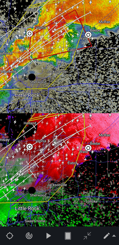
Is there a couplet or debris signature on that one?
No debris. I see what theyre warning but its not an impressive couplet. They need to get to shelter anyway.
 2
2

Posted on 12/10/21 at 7:24 pm to deltaland
quote:
Can you post that same look for the storm west of Beebe?

Posted on 12/10/21 at 7:24 pm to LegendInMyMind
Tornado warning in Fayetteville
Posted on 12/10/21 at 7:25 pm to pioneerbasketball
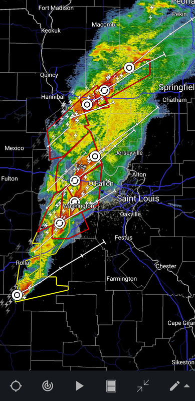
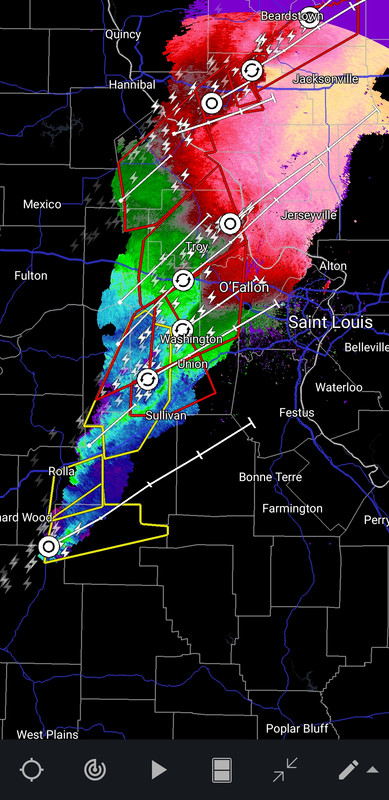
Anybody got info on st louis?
Posted on 12/10/21 at 7:25 pm to pioneerbasketball
quote:
Anybody got info on st louis?
It is about to get really windy.

Posted on 12/10/21 at 7:26 pm to LegendInMyMind
Continued
Posted on 12/10/21 at 7:26 pm to LegendInMyMind
Posted on 12/10/21 at 7:27 pm to pioneerbasketball
My security cameras got some good footage of the sky
Posted on 12/10/21 at 7:27 pm to Bobby OG Johnson
quote:
Spotter Network Inc
@spotternetwork
Spotr 1 miles N of BLACK OAK, AR @ 01:26 UTC TOR>-Wedge tornado 3 miles to my north north east with power flashes illuminating it
Posted on 12/10/21 at 7:28 pm to pioneerbasketball
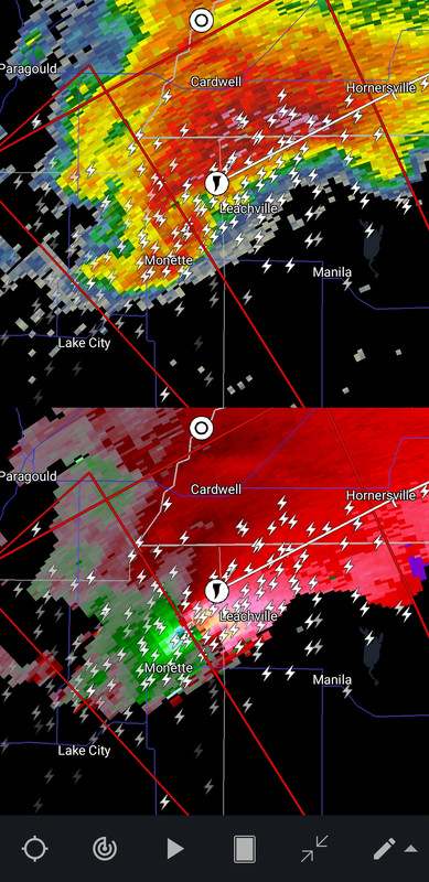
Monette and leachville about to get rocked.
Posted on 12/10/21 at 7:28 pm to Duke
quote:
No debris. I see what theyre warning but its not an impressive couplet. They need to get to shelter anyway.
Good. I worry about them in that double wide in the middle of a pasture they have nowhere to shelter. No ditch, no tornado shelter, nearest neighbor is 4-500 yards down the road and grandfather is almost blind and can’t drive at night, has a bad hip and grandma has COPD. My uncle lives 5 min away so hopefully he went and picked them up he has a large sturdy home
Posted on 12/10/21 at 7:29 pm to pioneerbasketball

Posted on 12/10/21 at 7:29 pm to LegendInMyMind
Monster, and it ain't stopping for a while.
Posted on 12/10/21 at 7:30 pm to Bobby OG Johnson
Posted on 12/10/21 at 7:30 pm to pioneerbasketball
..
This post was edited on 3/29/22 at 10:13 am

Posted on 12/10/21 at 7:30 pm to pioneerbasketball
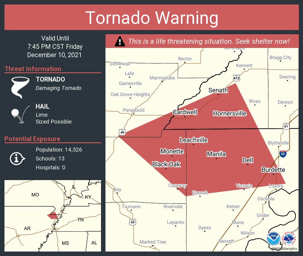
Severe Weather Statement
National Weather Service Memphis TN
725 PM CST Fri Dec 10 2021
ARC031-055-093-MOC069-110145-
/O.CON.KMEG.TO.W.0061.000000T0000Z-211211T0145Z/
Greene AR-Craighead AR-Mississippi AR-Dunklin MO-
725 PM CST Fri Dec 10 2021
...A TORNADO WARNING REMAINS IN EFFECT UNTIL 745 PM CST FOR
SOUTHEASTERN GREENE...NORTHEASTERN CRAIGHEAD...NORTHWESTERN
MISSISSIPPI AND SOUTHWESTERN DUNKLIN COUNTIES...
At 724 PM CST, a confirmed large and extremely dangerous tornado was
located over Monette, moving northeast at 45 mph.
This is a PARTICULARLY DANGEROUS SITUATION. TAKE COVER NOW!
HAZARD...Damaging tornado.
SOURCE...Weather spotters confirmed tornado.
IMPACT...You are in a life-threatening situation. Flying debris may
be deadly to those caught without shelter. Mobile homes
will be destroyed. Considerable damage to homes,
businesses, and vehicles is likely and complete destruction
is possible.
The tornado will be near...
Leachville around 730 PM CST.
Manila, Cardwell and Arbyrd around 735 PM CST.
Hornersville around 745 PM CST.
Gosnell around 750 PM CST.
Other locations impacted by this tornadic thunderstorm include
Jolliff Store, Delfore, Dearman, Lennie, Vail, Carmi, Whisp, Buckeye,
Lester and Arkmo.
PRECAUTIONARY/PREPAREDNESS ACTIONS...
Tornadoes are extremely difficult to see and confirm at night. Do not
wait to see or hear the tornado. TAKE COVER NOW!
&&
LAT...LON 3573 9029 3597 9056 3618 9009 3578 8989
TIME...MOT...LOC 0124Z 245DEG 40KT 3590 9034
TORNADO...OBSERVED
TORNADO DAMAGE THREAT...CONSIDERABLE
MAX HAIL SIZE...2.00 IN
$$
Posted on 12/10/21 at 7:30 pm to Duke
Warned cell headed to Fayetteville. Geez looks like every cell that pops up is ending up warned.
The moderate area definitely should have been expanded with a PDS
The moderate area definitely should have been expanded with a PDS
Posted on 12/10/21 at 7:30 pm to Pisco
KAIT is predicting Leachville could be facing an EF3.
Posted on 12/10/21 at 7:31 pm to deltaland
quote:
Good. I worry about them in that double wide in the middle of a pasture they have nowhere to shelter.
I looked at it when you first mentioned it. It hasn't looked as impressive as the others. But....in a mobile home, it doesn't have to look impressive. Hopefully they have somewhere they can go.

 Page 15 of 90

Popular
Back to top