- My Forums
- Tiger Rant
- LSU Recruiting
- SEC Rant
- Saints Talk
- Pelicans Talk
- More Sports Board
- Fantasy Sports
- Golf Board
- Soccer Board
- O-T Lounge
- Tech Board
- Home/Garden Board
- Outdoor Board
- Health/Fitness Board
- Movie/TV Board
- Book Board
- Music Board
- Political Talk
- Money Talk
- Fark Board
- Gaming Board
- Travel Board
- Food/Drink Board
- Ticket Exchange
- TD Help Board
Customize My Forums- View All Forums
- Show Left Links
- Topic Sort Options
- Trending Topics
- Recent Topics
- Active Topics
Started By
Message

 1
1


Posted on 1/30/22 at 4:35 pm to BeachDude022
Exactly what I need. Door just closed on my flight so I'll check when I get home 
If spirit posts a waiver take a dfw-fll flight on Wednesday to make sure you get out
If spirit posts a waiver take a dfw-fll flight on Wednesday to make sure you get out
Posted on 1/30/22 at 6:48 pm to CuseTiger
I rescheduled the first part of the flight for Wednesday afternoon. Better safe than sorry
Posted on 1/30/22 at 6:51 pm to BeachDude022
quote:
I rescheduled the first part of the flight for Wednesday afternoon. Better safe than sorry
Good call. You wont regret it.
Posted on 1/30/22 at 6:59 pm to BeachDude022
quote:
I rescheduled the first part of the flight for Wednesday afternoon. Better safe than sorry
Very glad you did that and if the weather guys are agreeing then it's likely to get bad. I'll start a travel board thread as soon as waivers start getting posted
Posted on 1/30/22 at 7:01 pm to CuseTiger
Thanks for the help!

Posted on 1/30/22 at 7:48 pm to Duke
You going to update those old-arse model runs? Cause they’re nowhere near that anymore?
Posted on 1/30/22 at 7:52 pm to 0x15E

Yeah, you right, today's runs are significantly different than yesterdays.

Posted on 1/30/22 at 8:07 pm to Duke
So were back to an Ice event?
Id rather deal with the snow.
Id rather deal with the snow.
Posted on 1/30/22 at 8:16 pm to 50_Tiger
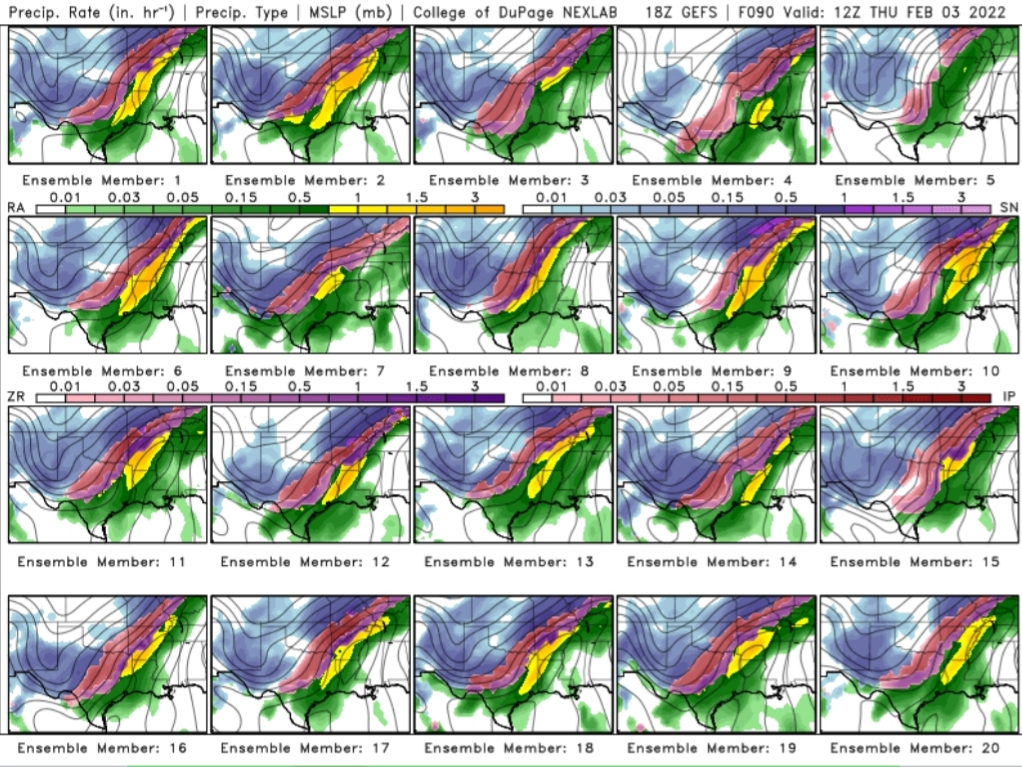
It hasn't changed on the models. rds thinks the models arent cooling down the above freezing layer aloft fast enough, and is showing ice when it really will be snow.
Its not an unreasonable idea, given winds should turn out of the north at that level when this image is shown and also precip falling through the level will help cool it some.
But the soundings remain pretty much saturated through that level, which would make the cooling less effective without some of the precip evaporating.
Its a really tricky forecast for DFW/Waco/Austin/SA
Posted on 1/30/22 at 9:20 pm to Duke
So much depends on how far SW the main upper shortwave/upper low tracks. Models now have it digging to around or north of El Paso. If it buries itself down deeper into Mexico then things change a good bit. If it does dig a bit deeper into Mexico you will see near blizzard conditions locally across North Texas but if it tracks north of EP then N TX may be a freezing rain and sleet mess. Us in East Texas could see a very nasty ice storm per the current GFS track. Midday Thu right now shows low 20s with heavy rain. Pwats over 1 with temps in 20s is pretty wild.
Posted on 1/30/22 at 9:24 pm to Duke
quote:
But the soundings remain pretty much saturated through that level, which would make the cooling less effective without some of the precip evaporating.
And those soundings are up and down the front. Gonna be interesting to watch it evolve.
Posted on 1/30/22 at 9:28 pm to LegendInMyMind
I think that qualifies as universal agreement:
Posted on 1/30/22 at 9:38 pm to LegendInMyMind
GFS has seemed to have a good handle on this event for a while. Op and ensembles are very consistent. Other models are all over the place though ICON also pretty solid.
Posted on 1/30/22 at 9:50 pm to aggiegeog
Getting the trough dig farther and more cooling should happen on the northern extent.

Posted on 1/30/22 at 9:54 pm to Duke
5:00p flight out of DAL on Thursday, should be fun
Posted on 1/30/22 at 10:07 pm to LegendInMyMind
I'll ride with 4, 9, 10
12, 17, 20 as consolations
12, 17, 20 as consolations
This post was edited on 1/30/22 at 10:09 pm
Posted on 1/30/22 at 10:18 pm to H2O Tiger
quote:
5:00p flight out of DAL on Thursday, should be fun
That is probably more of a hypothetical flight... especially if expecting no delay
Posted on 1/30/22 at 10:24 pm to Duke
DAL-ATL-MSY, 41m connection in ATL. Was already gonna be tight but I guess we'll see how well Delta at DAL handles IRROPS.
Posted on 1/30/22 at 10:28 pm to H2O Tiger
41 minutes in Atlanta?
I too enjoy living dangerously
I too enjoy living dangerously

 Page 5 of 32

Popular
Back to top