- My Forums
- Tiger Rant
- LSU Recruiting
- SEC Rant
- Saints Talk
- Pelicans Talk
- More Sports Board
- Fantasy Sports
- Golf Board
- Soccer Board
- O-T Lounge
- Tech Board
- Home/Garden Board
- Outdoor Board
- Health/Fitness Board
- Movie/TV Board
- Book Board
- Music Board
- Political Talk
- Money Talk
- Fark Board
- Gaming Board
- Travel Board
- Food/Drink Board
- Ticket Exchange
- TD Help Board
Customize My Forums- View All Forums
- Show Left Links
- Topic Sort Options
- Trending Topics
- Recent Topics
- Active Topics
Started By
Message
re: Storm Update:- Ida Moves Away - The Cleanup Begins...
Posted on 8/26/21 at 11:04 pm to Thib-a-doe Tiger
Posted on 8/26/21 at 11:04 pm to Thib-a-doe Tiger
You a cop?
 2
2


Posted on 8/26/21 at 11:05 pm to BigHoss
quote:
What is the best room to put the generator in to make sure it stays dry while running?
Your bedroom for sure

Posted on 8/26/21 at 11:05 pm to BigHoss
This would be VERY bad for Houma and Coyote.
Posted on 8/26/21 at 11:05 pm to BigHoss
quote:
You a cop?
You know I don’t really have to tell you, right?

Posted on 8/26/21 at 11:05 pm to SippyCup
quote:
What is the best room to put the generator in to make sure it stays dry while running?
Duh! The kitchen.
Exactly. Just hook the gas from the stove right into it.
Posted on 8/26/21 at 11:05 pm to tiger91
The HWRF is our best at intensity.
It's decent on track, but you really can't beat the model blend anyway.
It's decent on track, but you really can't beat the model blend anyway.

Posted on 8/26/21 at 11:05 pm to Oates Mustache
Posted on 8/26/21 at 11:07 pm to Oates Mustache
The GFS Simulated IR going crazy. But I guess it is a possibility. Let's hope not.

Posted on 8/26/21 at 11:07 pm to TheRouxGuru
quote:
I know nobody here cares about us, but Plaquemines Parish
Self-aware man. I respect it
Posted on 8/26/21 at 11:07 pm to NorthEndZone
Well a borderline category 3/4 hurricane would tend to look like that.
Posted on 8/26/21 at 11:08 pm to TDsngumbo
I’m starting to believe we will see weeks-long power outages if this all actually happens.
Posted on 8/26/21 at 11:08 pm to NorthEndZone
quote:
The GFS Simulated IR going crazy. But I guess it is a possibility. Let's hope not.
Those colors are scary.
Posted on 8/26/21 at 11:08 pm to BigHoss
quote:
Meteorologist Nick Mikulas
...
Ida is moving along at a decent pace, and should continue on that general path for the next few days, though the forward speed may gradually slow. The ridge of high pressure building over the Carolinas could cause a slight bend to the west, which would seem insignificant, but could have huge implications for our area. The latest NHC forecast nudged just a hair to the east, but even with a storm passing 50 miles east of Alexandria, we’d still feel significant impacts. As I’ve said many times, don’t focus on that center track line. Focus on the cone. Our entire area is in the cone of uncertainty, so no one should let their guard down.
The aircraft investigating Ida is showing a weakly defined center, but much stronger winds well to the east and northeast. It’s possible we will see a center relocation as thunderstorms increase overnight. That could of course have an impact on the future track of Ida. I should know a lot more by tomorrow morning, and be able to do a parish by parish forecast by tomorrow evening. It does appear that Ida will make a run at category 3 intensity. Intensity is tricky, but you need to be prepared for a category 3 hurricane along the coast, and the potential for hurricane force wind gusts well inland. It also appears that Ida will slow down after landfall, which could bring flooding problems near the center, and to the east.
Remember, don’t focus on the track. Just because you are west of it doesn’t mean you’re in the clear. There will be significant impacts 50 miles west of the track. It’s just that the problems extend much further out along the east side. Make sure you have any preparations done by Saturday evening. We could start seeing fringe effects from Ida during the day Sunday. The forecast track error is about 120 miles 3 days from landfall. A 50-100 mile swing to the west means the entire area gets a big dose of Ida. A 50-100 mile shift east means we wouldn’t get much. So it’s a massive difference. Given the pattern, I think slight westward shifts are more likely than eastward shifts, but we shall see. I really think I’ll be able to pin this down with reasonable certainty by tomorrow. But it’s probably time to start prepping things.
Posted on 8/26/21 at 11:09 pm to TDsngumbo
Where you live baw?

Posted on 8/26/21 at 11:09 pm to maisweh
Met I know said this:
I’m asking which ones.
quote:
Experimental models coming in. Looking at low end cat 4. I think high 3 low 4 is very reasonable
I’m asking which ones.
Posted on 8/26/21 at 11:09 pm to Oates Mustache
God’s country north of St. Amant
Posted on 8/26/21 at 11:10 pm to maisweh
quote:
Those colors are scary.
Racist
Posted on 8/26/21 at 11:10 pm to Cosmo
Aren’t you a doctor??
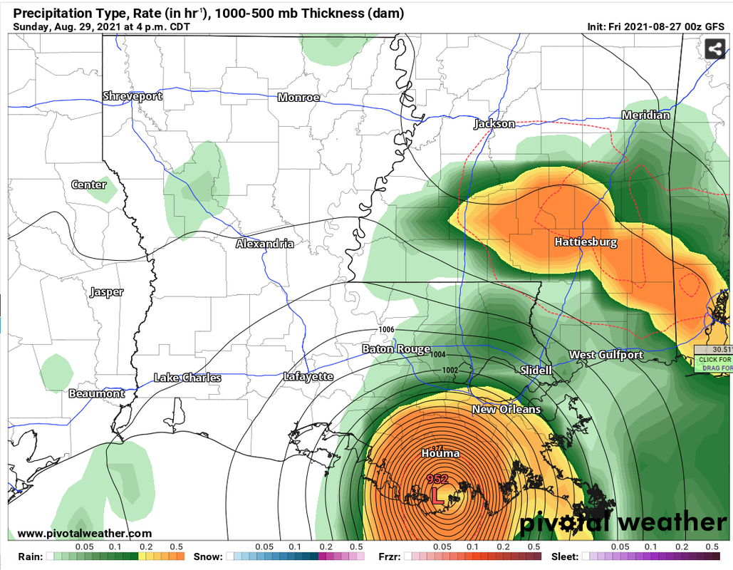
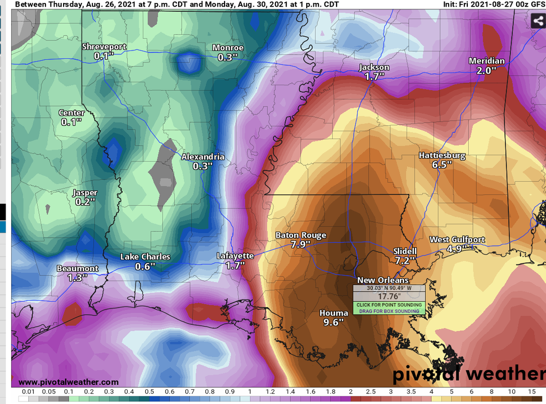
Posted on 8/26/21 at 11:10 pm to rt3
New Orleans would get 18" of rain on that run BTW (I sniped this from StormCast)
Posted on 8/26/21 at 11:10 pm to Thib-a-doe Tiger
Random fact, but the US used female-only names for storms from 1954 to 1979.

 Page 157 of 1029

Popular
Back to top