- My Forums
- Tiger Rant
- LSU Recruiting
- SEC Rant
- Saints Talk
- Pelicans Talk
- More Sports Board
- Fantasy Sports
- Golf Board
- Soccer Board
- O-T Lounge
- Tech Board
- Home/Garden Board
- Outdoor Board
- Health/Fitness Board
- Movie/TV Board
- Book Board
- Music Board
- Political Talk
- Money Talk
- Fark Board
- Gaming Board
- Travel Board
- Food/Drink Board
- Ticket Exchange
- TD Help Board
Customize My Forums- View All Forums
- Show Left Links
- Topic Sort Options
- Trending Topics
- Recent Topics
- Active Topics
Started By
Message

 1
1

Posted on 8/28/16 at 9:39 pm to crazycubes
when is next update
Posted on 8/28/16 at 9:40 pm to rds dc
quote:
This would put it on the SW edge of the guidance spread.
been wondering if this will shift models again
Posted on 8/28/16 at 9:44 pm to rds dc
quote:
This would put it on the SW edge of the guidance spread
And that changes the model but which direction?? Anything over Texas coming that would keep it east of Louisiana?

Posted on 8/28/16 at 9:44 pm to Leadhead
quote:
Better for Louisiana that it's Viosca Knoll and not a more western block I guess. is that south of Mobile.? And who is shutting down flights?
Yea, bout 100 miles due south of Daphne. We fly out of Houma.
PHI said they had to have 72 hours to do what they needed to do with the aircraft and let their employees handle personal issues, so there would be no flights after Monday/Tuesday...
quote:
The models support that tripling all chemical rates on the platform may help push the storm away. Give it a shot.
Ah... I see we have a Nalco rep in the house
This post was edited on 8/28/16 at 9:47 pm

Posted on 8/28/16 at 9:49 pm to rds dc
I have absolutely no knowledge of this stuff like you guys, but looking at radar, satellite, etc, etc, it looks like the center is still skirting along the 24th, and not over Cuba at all.
Posted on 8/28/16 at 9:51 pm to Fratigerguy
Update out. No change in intensity forecast or projected path.
This post was edited on 8/28/16 at 9:52 pm
Posted on 8/28/16 at 10:05 pm to LSUTiger23
11 PM update shifted east!!!
Posted on 8/28/16 at 10:07 pm to macatak911
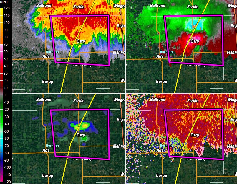
Off topic, but there is a massive multi vortex tornado up by Gary, Minnesota at the moment.

Posted on 8/28/16 at 10:13 pm to macatak911
Link?

Posted on 8/28/16 at 10:17 pm to macatak911
Not according to NHC
Posted on 8/28/16 at 10:20 pm to udtiger
This storm is impressive in the fact that it's been so shitty but still has had people gripped since Wednesday
Posted on 8/28/16 at 10:25 pm to udtiger
quote:
Not according to NHC
The NHC update moved the cone on the western side further away from louisiana.
Posted on 8/28/16 at 10:27 pm to macatak911
quote:
Not according to NHC

left is 11 PM right is earlier in day
This post was edited on 8/28/16 at 10:29 pm

Posted on 8/28/16 at 10:46 pm to macatak911
It could be good, but this thing is still a crapshoot this far out. They have no idea what this thing is gonna do

Posted on 8/28/16 at 10:47 pm to macatak911
Should we all go in on a gift basket for Florida for taking this one for the team?
Posted on 8/28/16 at 11:01 pm to LSUJuice
We aren't out of the woods yet. The more WNW movement and with the ridge holding as of now, it's already forecasted to stengthen.
To the experts: if you had to put a % on an LA hit/partial hit, what's your number?
To the experts: if you had to put a % on an LA hit/partial hit, what's your number?

Posted on 8/28/16 at 11:04 pm to SomethingLikeA
Bump
Posted on 8/28/16 at 11:04 pm to LSUJuice
It's not something they are looking forward to I'm sure, some areas of there got 15 plus inches of rain about the time we got all our rain. Even though this probably won't be a hurricane when it hits, it's really going to suck for them. Best they can hope for is that the cold front coming through pushes it through relatively quickly.
Posted on 8/28/16 at 11:04 pm to SomethingLikeA
quote:
To the experts: if you had to put a % on an LA hit/partial hit, what's your number?
FWIW, no "expert" would have the audacity to put a % on an LA landfall this far out.

 Page 134 of 175

Back to top