- My Forums
- Tiger Rant
- LSU Recruiting
- SEC Rant
- Saints Talk
- Pelicans Talk
- More Sports Board
- Coaching Changes
- Fantasy Sports
- Golf Board
- Soccer Board
- O-T Lounge
- Tech Board
- Home/Garden Board
- Outdoor Board
- Health/Fitness Board
- Movie/TV Board
- Book Board
- Music Board
- Political Talk
- Money Talk
- Fark Board
- Gaming Board
- Travel Board
- Food/Drink Board
- Ticket Exchange
- TD Help Board
Customize My Forums- View All Forums
- Show Left Links
- Topic Sort Options
- Trending Topics
- Recent Topics
- Active Topics
Started By
Message
 2
2


Posted on 10/3/16 at 10:18 pm to rds dc
quote:
rds dc
Posted on 10/3/16 at 10:20 pm to tigertown80
quote:during hurricane Charley in '04 they closed early, like around noon/ early afternoon. (It was the first time ever) Charley rolled thru with up to 105 mph gusts around 9:00 that night. Amazingly they were open at the regular time the next morning.
When do they close the parks if it get bad?
Posted on 10/3/16 at 10:22 pm to 10MTNTiger
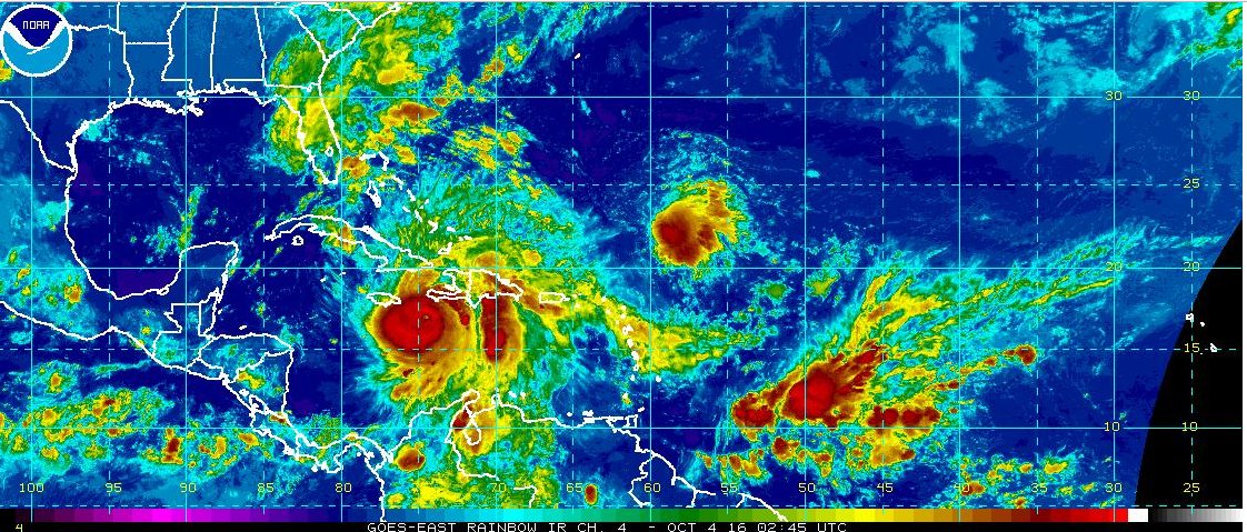
10MTNTiger, here is the key part of the latest from the NHC for you in GTMO.
FORECAST VALID 05/0000Z 20.0N 74.4W
MAX WIND 120 KT...GUSTS 145 KT.
64 KT... 40NE 40SE 35SW 35NW.
50 KT... 80NE 70SE 60SW 70NW.
34 KT...170NE 130SE 100SW 120NW.
As of now, the hurricane force winds are forecast to extend outward 35 nautical miles or about 40 statute miles to the NW of the center. 40 miles west of 74.4W is right about 75.1W which is the eastern side of Guantonomo Bay. So it looks like weak Cat 1 conditions there with Cat 2 gusts possible. Nothing to sneeze at but well built structures should be fine.
This post was edited on 10/3/16 at 10:23 pm
Posted on 10/3/16 at 10:22 pm to rds dc
Graphic below shows every NHC forecast cone and the 18z GEFS:

Posted on 10/3/16 at 10:23 pm to otowntiger
almost GFS time. My parents live in NY State and an Irene style flood would be awful for their area, most parts of upstate NY still havent recovered from the 2011 floods.
Posted on 10/3/16 at 10:24 pm to rds dc
Honestly, I am more worried about the Bahamas with winds. Port-au-Prince Haiti has a very small chance of seeing hurricane force winds. The core of the storm will be significantly west of that that city. It will be the rain that will be the problem in Port-au-Prince.

Posted on 10/3/16 at 10:26 pm to LSUneaux
Any chance this will effect MNF next week in Carolina vs Tampa?

Posted on 10/3/16 at 10:28 pm to LSUwag
quote:
few years ago I was on a cruise that visited Labade which is their national park (for tourists only). There is a wall around it with patrols on 4x4 trucks with machine guns. When the truck would pass, kids would come to the fence and beg for food. It was heartbreaking and made you ashamed of yourself
Labadie is the private resort of Royal Caribbean Cruise Lines. Apparently they bought the property and that's the only place you go when going to the Island. Whereas other ports of call you are free to do basically whatever you want, on this port , you pretty much are fenced into a certain area. Don't know if that has more to do with the Haitian political situation or more to do with RCL just wanting to keep all its cruisers in one money making spot.
Posted on 10/3/16 at 10:28 pm to LSUwag
What cruise line?
ETA: just saw, nvm
ETA: just saw, nvm
This post was edited on 10/3/16 at 10:30 pm
Posted on 10/3/16 at 10:30 pm to rds dc
Bad night fore the whole of Hispaniola. Matthew will move across western Haiti tonight and it looks like a very large outer band is setting up over DR.
Posted on 10/3/16 at 10:36 pm to rds dc
GFS now running
Posted on 10/3/16 at 10:39 pm to rds dc
man, that does look bad....pretty much no avoiding it for those folks now...
Posted on 10/3/16 at 10:39 pm to Col Reb is my mascot
Royal Caribbean
Great cruise line but, that bothered me. They tried to keep people away from that area so, I of course checked it out.
Great cruise line but, that bothered me. They tried to keep people away from that area so, I of course checked it out.


Posted on 10/3/16 at 10:42 pm to rds dc

I may have mentioned this in a previous hurricane thread, but I often wonder if the shape of the east coast of the US is shaped the way it is due to tropical impacts. You see storm tracks like this all the time. It seems to fit too perfectly to be coincidental.
This post was edited on 10/3/16 at 10:51 pm

Posted on 10/3/16 at 10:43 pm to slackster
Or maybe storms follow that path because of the shape of the US
Posted on 10/3/16 at 10:43 pm to LSUneaux
God's about to wipe that place clean.
Posted on 10/3/16 at 10:44 pm to rds dc
Wow. That's an amazing shot. We just just flew out of DR Friday night. Damn that was close
Posted on 10/3/16 at 10:45 pm to LSUneaux
That's horrible.

 Page 42 of 181

Popular
Back to top