- My Forums
- Tiger Rant
- LSU Recruiting
- SEC Rant
- Saints Talk
- Pelicans Talk
- More Sports Board
- Coaching Changes
- Fantasy Sports
- Golf Board
- Soccer Board
- O-T Lounge
- Tech Board
- Home/Garden Board
- Outdoor Board
- Health/Fitness Board
- Movie/TV Board
- Book Board
- Music Board
- Political Talk
- Money Talk
- Fark Board
- Gaming Board
- Travel Board
- Food/Drink Board
- Ticket Exchange
- TD Help Board
Customize My Forums- View All Forums
- Show Left Links
- Topic Sort Options
- Trending Topics
- Recent Topics
- Active Topics
Started By
Message
 0
0


Posted on 9/28/16 at 7:21 pm to rds dc
quote:
D9
That's still so far out.
I know improvements on tracking have increased for D3 - D5, but has there been any evidence that we've gotten better for so far out in time?
Posted on 9/28/16 at 7:33 pm to East Coast Band
quote:
but has there been any evidence that we've gotten better for so far out in time?
Not for GFS. That's why they're spending so much time, energy, effort, and money working on its replacement.
Posted on 9/28/16 at 8:16 pm to CFDoc
What day are we in re D3, D4, etc ?
This post was edited on 9/28/16 at 8:17 pm
Posted on 9/28/16 at 9:35 pm to Drop4Loss
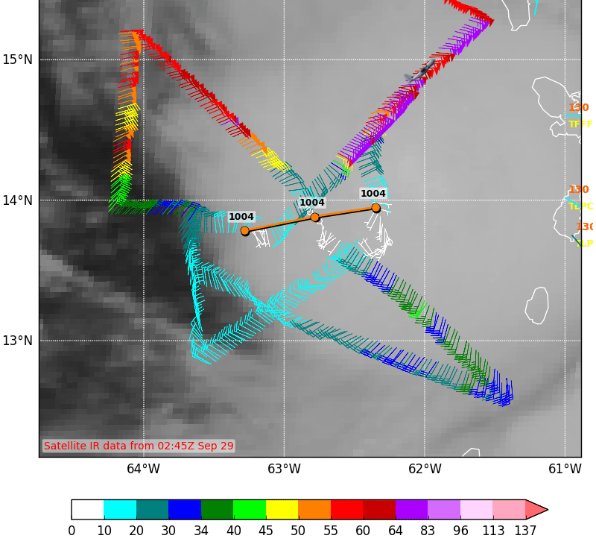
Slowly getting better organized with recon showing a LLC that doesn't look as sloppy as this morning but it is still on the western edge of the convection. This suggest that the LLC is still a little out ahead of the mid level spin.

Posted on 9/28/16 at 9:44 pm to East Coast Band
quote:
I know improvements on tracking have increased for D3 - D5, but has there been any evidence that we've gotten better for so far out in time?
The NHC does an internal forecast out to D7. They don't officially post this but they do coordinate with WPC on the 7 day forecast. This is from this evening:

Posted on 9/28/16 at 9:44 pm to East Coast Band
Recon for this evening:

This post was edited on 9/28/16 at 9:46 pm
Posted on 9/28/16 at 9:46 pm to rds dc
looks like a due west with a slight south component in movement this evening
Posted on 9/28/16 at 10:10 pm to lsuman25
000
WTNT44 KNHC 290251
TCDAT4
TROPICAL STORM MATTHEW DISCUSSION NUMBER 3
NWS NATIONAL HURRICANE CENTER MIAMI FL AL142016
1100 PM AST WED SEP 28 2016
Matthew crossed a portion of the Lesser Antilles today, and
tropical-storm-force winds were experienced in various islands for
several hours. The strongest winds appeared to have occurred in
Martinique which was located in the northeastern quadrant of the
storm. An Air Force plane currently investigating Matthew measured
a peak wind at 850-mb of 73 kt, while the SFMR instrument measured
54 kt. The minimum central pressure was 1004 mb. There are no signs
of an inner core yet, but the cloud pattern has increased in
organization, and the initial intensity was adjusted upward to 55
kt.
Matthew is forecast to move over warm waters and relatively low
shear during the next few days, and these conditions should lead to
gradual strengthening. There is a possibility, however, that
Matthew encounters some westerly shear in the central Caribbean well
south of Haiti in a day or two. This is an area climatologically
unfavorable for storms to intensify, and Matthew could reduce its
rate of strengthening there. After that, most of the models show a
more conducive upper-level environment, and Matthew could intensify
at a faster rate. The NHC forecast is not very different from its
predecessor and follows closely the intensity consensus.
Fixes from an Air Force plane indicate that Matthew is moving
toward the west or 270 degrees at 13 kt. A strong subtropical
ridge over the Atlantic is steering Matthew westward, and some
models even move the cyclone south of due west. Most of the guidance
is very consistent with this track during the next 48 hours. After
that time, guidance becomes more divergent, but in general, all
models turn the cyclone toward the northwest and north. Of the
historically reliable models, the westernmost track is the ECMWF
ensemble mean while the easternmost is the HWRF. The NHC track
forecast is in the middle of the TVCX and TVCN multi-model
consensus, and does not depart very much from the previous official
forecast.
There will be very interesting days ahead as Matthew moves toward
the central and western Caribbean Sea, and users are reminded that
the average NHC track errors at days 4 and 5 are on the order of 180
and 240 miles, respectively.
FORECAST POSITIONS AND MAX WINDS
INIT 29/0300Z 13.9N 63.1W 55 KT 65 MPH
12H 29/1200Z 14.3N 65.3W 60 KT 70 MPH
24H 30/0000Z 14.4N 67.9W 65 KT 75 MPH
36H 30/1200Z 14.3N 70.0W 70 KT 80 MPH
48H 01/0000Z 14.1N 71.5W 75 KT 85 MPH
72H 02/0000Z 14.5N 73.5W 75 KT 85 MPH
96H 03/0000Z 16.8N 75.0W 90 KT 105 MPH
120H 04/0000Z 20.0N 75.5W 90 KT 105 MPH
$$
Forecaster Avila
Posted on 9/28/16 at 10:12 pm to rds dc
Avila is my favorite, he is always colorful with his wording in the advisories.
Posted on 9/28/16 at 10:23 pm to lsuman25
quote:
Avila is my favorite, he is always colorful with his wording in the advisories.
Yeah, I think that last part is code word for, "if we bust majorly on this, F you!"
Posted on 9/28/16 at 10:30 pm to lsuman25
Looks like the 18z GFS & HWRF are going to end up too strong and too far north in the short range.
Posted on 9/28/16 at 10:32 pm to rds dc
Some OT ballers boat didn't make it through the day down in Barbados

Posted on 9/28/16 at 10:55 pm to rds dc
Pretty steady short term SW trend on the last 3 GFS runs through 72 hrs.
Posted on 9/28/16 at 11:01 pm to rds dc
Dang it. I told them to dry dock my boat.
Just can't get good help these days.
Just can't get good help these days.
Posted on 9/28/16 at 11:11 pm to rds dc
Well hell...guess it's time to restock the old charcoal and jim beam stash anyway

Posted on 9/29/16 at 2:12 am to rds dc
quote:GFDL is pretty much the only model keeping it as far south as it's been so far. It's also one of only a few models that keeps it west of Jamaica eventually... now that's not really something to worry about yet, but it's interesting.
Looks like the 18z GFS & HWRF are going to end up too strong and too far north in the short range.
Posted on 9/29/16 at 4:43 am to lsuman25
quote:meh... I prefer Stewart.
Avila is my favorite, he is always colorful with his wording in the advisories.
Posted on 9/29/16 at 4:46 am to baytiger
quote:interesting for sure. Due to its remarkable consistency for a while now, I believe the GFS will be right and this thing will further east than the NHC forecast now.
GFDL is pretty much the only model keeping it as far south as it's been so far. It's also one of only a few models that keeps it west of Jamaica eventually... now that's not really something to worry about yet, but it's interesting.
Posted on 9/29/16 at 5:25 am to otowntiger
Their all good to be fair, anyway Matthew is still being sheared as the convection blob is displaced to the north and east of the center.

 Page 12 of 181

Back to top