- My Forums
- Tiger Rant
- LSU Recruiting
- SEC Rant
- Saints Talk
- Pelicans Talk
- More Sports Board
- Coaching Changes
- Fantasy Sports
- Golf Board
- Soccer Board
- O-T Lounge
- Tech Board
- Home/Garden Board
- Outdoor Board
- Health/Fitness Board
- Movie/TV Board
- Book Board
- Music Board
- Political Talk
- Money Talk
- Fark Board
- Gaming Board
- Travel Board
- Food/Drink Board
- Ticket Exchange
- TD Help Board
Customize My Forums- View All Forums
- Show Left Links
- Topic Sort Options
- Trending Topics
- Recent Topics
- Active Topics
Started By
Message
re: South East TX Rain Storm In Game Thread Day 5 (50 - 90% till Saturday)
Posted on 5/9/19 at 10:54 am to ztro4

Posted on 5/9/19 at 10:54 am to ztro4
quote:
Well shite, was supposed to travel from BR to Houston Saturday for Stros game...guess that isn't looking likely now.
Yeah from the little I have seen since last night Friday night and all of Saturday may be the worst of it. Just check it Saturday morning and you might get a decent window to make it in.
 0
0


Posted on 5/9/19 at 4:47 pm to tketaco
I ain't seent a Goddamn rain here all day!!

Posted on 5/9/19 at 5:18 pm to tketaco
Bump. you can see it starting to form in the north east. Its gonna open up for round two probably within the next few hours
Posted on 5/9/19 at 5:54 pm to tketaco
quote:
I ain't seent a Goddamn rain here all day!!
Wait till tonight and into the early morning, got a MCS showing up on high res modeling.
Posted on 5/9/19 at 6:38 pm to Duke
West Houston is getting dumped on right now
Posted on 5/9/19 at 6:57 pm to tketaco
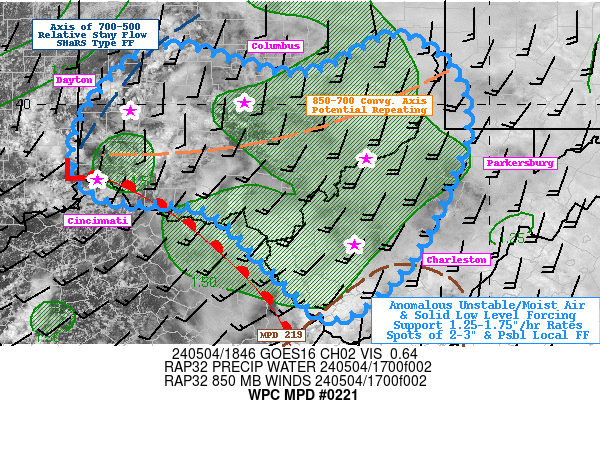
Mesoscale Precipitation Discussion 0221
NWS Weather Prediction Center College Park MD
608 PM EDT Thu May 09 2019
Areas affected...Southern Louisiana, Southeast Texas
Concerning...Heavy rainfall...Flash flooding likely
Valid 092208Z - 100300Z
Summary...Widespread, slow-moving thunderstorms will continue in
southern Louisiana for at least another couple hours. Additional
thunderstorm development is likely in the coastal plain of
southeast Texas, and thunderstorms should become more numerous in
the evening hours. Flash flooding will continue to be likely in
southern Louisiana, and there will be an increasing flash flood
threat in southeast Texas. Localized significant flooding and
inundation cannot be ruled out.
Discussion...Regional radar trends over the past several hours in
southern Louisiana show virtually no movement to the west-east
oriented convective band. There has been a gradual southward drift
into the low-level inflow and region of strong instability, and
recent loops from KLIX and KLCH radars have shown outflow
boundaries beginning to propagate south away from the leading edge
of higher reflectivity. This may be signaling the beginning of a
gradual weakening trend to the ongoing convection. However, these
radars also still show a fairly wide convective band (approx 35mi
wide) with pockets of very heavy rain rates (2-3 in/hr MRMS and
dual pol). Even in the midst of a general diminishing trend, heavy
rain would be likely for another couple hours, and given the
continued slow overall motion of the convective band, considerable
rain rates would be likely to overlap with already saturated
soils. Therefore, flash flooding remains likely over much of
southern Louisiana. An additional hour or two of heavy rain may
make the flooding more widespread and/or significant, with deeper
inundation possible in some areas. This would be particularly true
in urban areas that see sustained thunderstorm activity; for
instance, the CREST hydrologic model is beginning to show a more
significant response in the maximum unit streamflow field in the
vicinity of Baton Rouge, which has seen several inches of rain in
just over an hour.
Further to the west, in southeast Texas, isolated thunderstorm
development has begun along a surface convergence zone situated
just inland from the Gulf of Mexico coastline. Convective coverage
is expected to increase over the next several hours as boundary
layer winds begin to increase and shift to a southeasterly
direction. The increased inflow off the Gulf should lead to an
uptick in PW values closer to 2 inches, and may increase the
low-level convergence along the boundary. These factors are likely
to lead to more convective development as we approach the 00Z time
frame. Recent hi-res model runs generally support this conclusion,
in particular the 18Z NAM Nest and the 21Z experimental Warn On
Forecast System. The HRRR seems to be too suppressed as it reduces
convective coverage and intensity too fast in southern Louisiana
and focuses most of the development well west near the Rio Grande.
In an environment with strong instability and PW values increasing
to near 2 inches, rain rates of 2-3 in/hr will be reasonable.
Given that convection should be focused near the low-level
convergence axis, this may sustain heavy rain at some locations
for a couple hours and lead to localized rainfall maxima in excess
of 3 inches by 04Z. An alternative scenario is that convective
development will remain more isolated through the early evening
(suggested by the HRRR), and increase more in the 06-12Z time
frame. This scenario may be less likely but cannot be ruled out.
Lamers
ATTN...WFO...CRP...EWX...HGX...LCH...LIX...

Posted on 5/9/19 at 6:58 pm to tketaco
Well they have been saying it was coming tonight.
Posted on 5/9/19 at 7:26 pm to bigberg2000
Gonna need Galveston shut down all around so I can avoid tomorrows meeting. Been working PM/National Guard 2 weeks straight now.

Posted on 5/9/19 at 8:02 pm to tketaco
And I am working from home tomorrow
Posted on 5/9/19 at 9:23 pm to tketaco
Rains and winds picking up in Southeast Houston. shite getting real.

Posted on 5/9/19 at 9:38 pm to tketaco
(no message)
This post was edited on 4/7/23 at 3:06 pm

Posted on 5/9/19 at 9:38 pm to tketaco
EADO is crack a lackin
Posted on 5/9/19 at 9:38 pm to tketaco
Keep that storm in Baton Rouge/Washington parish and leave Orleans alone.
Posted on 5/9/19 at 9:51 pm to msutiger
Oh it’s gotten really heavy now. Lightening is bad baws. House is shaking.

Posted on 5/9/19 at 9:53 pm to tketaco
Houston looks bad right now.
Posted on 5/9/19 at 10:04 pm to TH03
It’s not great right now
Posted on 5/9/19 at 10:12 pm to tketaco
The amount of rain falling on US 90 between 610 and the beltway north of Jacinto City is incredible on radar.

.8 inches of rain in 5 fricking minutes.
.8 inches of rain in 5 fricking minutes.
Posted on 5/9/19 at 10:12 pm to ShaneTheLegLechler
My street flooding slightly over the curb. Sucker's parked on the street kinda fricked.
ETA: storm rage has died down a bit for the moment.
ETA: storm rage has died down a bit for the moment.
This post was edited on 5/9/19 at 10:13 pm
Posted on 5/9/19 at 10:13 pm to slackster
That area flooded earlier this week badly. It already wasn’t prepared to handle heavy rain
Posted on 5/9/19 at 10:17 pm to msutiger
Greens Bayou at Normandy Street just north of I-10 just got 2.6" in 20 minutes.

 Page 6 of 11

Popular
Back to top