- My Forums
- Tiger Rant
- LSU Recruiting
- SEC Rant
- Saints Talk
- Pelicans Talk
- More Sports Board
- Fantasy Sports
- Golf Board
- Soccer Board
- O-T Lounge
- Tech Board
- Home/Garden Board
- Outdoor Board
- Health/Fitness Board
- Movie/TV Board
- Book Board
- Music Board
- Political Talk
- Money Talk
- Fark Board
- Gaming Board
- Travel Board
- Food/Drink Board
- Ticket Exchange
- TD Help Board
Customize My Forums- View All Forums
- Show Left Links
- Topic Sort Options
- Trending Topics
- Recent Topics
- Active Topics
Started By
Message
re: Significant Friday evening east Texas severe weather threat
Posted on 11/4/22 at 1:11 pm to LegendInMyMind

Posted on 11/4/22 at 1:11 pm to LegendInMyMind
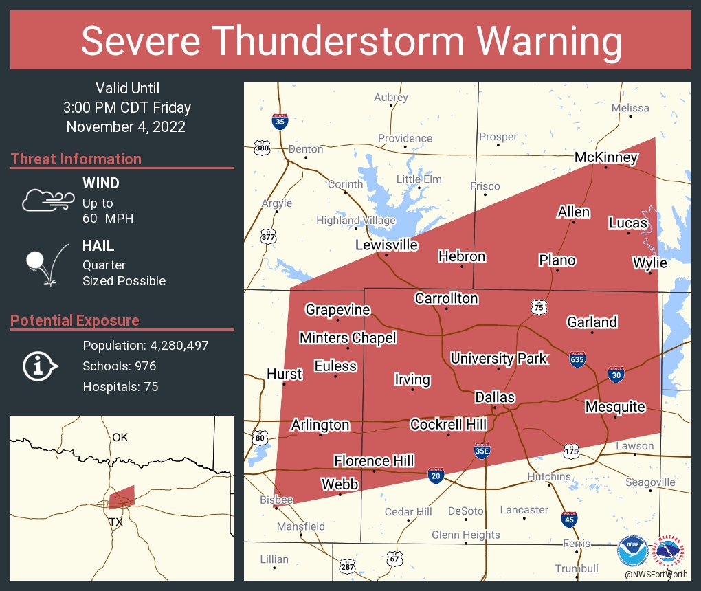
First tornado watch of the afternoon:

Probabilities within the watch:
Tornadoes
Probability of 2 or more tornadoes - High (70%)
Probability of 1 or more strong (EF2-EF5) tornadoes - Mod (50%)
Wind
Probability of 10 or more severe wind events - High (70%)
Probability of 1 or more wind events > 65 knots - Mod (60%)
URGENT - IMMEDIATE BROADCAST REQUESTED
Tornado Watch Number 560
NWS Storm Prediction Center Norman OK
100 PM CDT Fri Nov 4 2022
The NWS Storm Prediction Center has issued a
* Tornado Watch for portions of
Northwest Arkansas
Eastern and Southern Oklahoma
North Central and Northeast Texas
* Effective this Friday afternoon and evening from 100 PM until
800 PM CDT.
* Primary threats include...
A few tornadoes likely with a couple intense tornadoes possible
Scattered damaging winds and isolated significant gusts to 80
mph likely
Scattered large hail and isolated very large hail events to 2
inches in diameter possible
SUMMARY...Thunderstorms will continue to increase in coverage and
intensity this afternoon, with scattered severe storms expected.
Strong winds aloft and a moist environment will pose a risk of
tornadoes and damaging wind gusts in the strongest cells.
The tornado watch area is approximately along and 80 statute miles
east and west of a line from 50 miles northwest of Fayetteville AR
to 25 miles east of Temple TX. For a complete depiction of the watch
see the associated watch outline update (WOUS64 KWNS WOU0).
 3
3

Posted on 11/4/22 at 1:18 pm to Roll Tide Ravens
Yep. I'm under a tornado warning right now. Warning issued about 10 minutes ago and until 2 pm.
This post was edited on 11/4/22 at 1:19 pm
Posted on 11/4/22 at 1:46 pm to El Segundo Guy
The warning got extended until 2:30 here.
Posted on 11/4/22 at 1:47 pm to Roll Tide Ravens
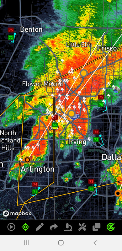
The latest RadarScope update has dickered how it loads and refreshes warnings. I have to force stop the app to fix. fricking annoying!
Radar Omega is still going strong, never a problem.
ETA: Also, storms are going to be in a radar hole for a large part of this afternoon. That'll really make it difficult to spot QLCS tornadoes.
Radar Omega is still going strong, never a problem.
ETA: Also, storms are going to be in a radar hole for a large part of this afternoon. That'll really make it difficult to spot QLCS tornadoes.
This post was edited on 11/4/22 at 1:49 pm
Posted on 11/4/22 at 1:49 pm to Roll Tide Ravens
Reed is LIVE in the DFW area
Posted on 11/4/22 at 1:54 pm to rds dc
Reed tricked me earlier. He went live a couple hours ago. I thought he was on something. 
This post was edited on 11/4/22 at 1:55 pm
Posted on 11/4/22 at 1:58 pm to rds dc
Temps in the low 80s and dews in the low to mid 70s across the warm sector. Surface winds whipping out of the SSE at near 20 with gusts over 30.

Posted on 11/4/22 at 2:00 pm to rds dc
im gonna catch this Tarrant Cell. Just need it to relax and get out to the rural area. A lot of people in the path of this cell.
Posted on 11/4/22 at 2:08 pm to 50_Tiger
It is probably going to take these cells building upstream some to get themselves going. They'll probably look more like a cluster than a classic supercell.
The little cells down around Waco are the ones to really watch. They've done some work, but still have a ways to go.
The little cells down around Waco are the ones to really watch. They've done some work, but still have a ways to go.
This post was edited on 11/4/22 at 2:09 pm
Posted on 11/4/22 at 2:11 pm to 50_Tiger
Wouldn't be surprised if this gets flipped to a Tornado Warning here in a bit.

This post was edited on 11/4/22 at 2:13 pm
Posted on 11/4/22 at 2:14 pm to LegendInMyMind
My 69 Chrysler convertible is scheduled for use in a homecoming parade in NW La at 6 p.m. I thought the parade would cancel but at this point they think they can beat the weather. It is a short parade, so they should finish at 6:30 p.m. and I'll have a 15 minute drive home.
Car has only been in the rain once since the big Delta microburst airline crash at DFW (we were top up on the highway north of the airport at the time - missed the microburst by about a mile and a half).
Car has only been in the rain once since the big Delta microburst airline crash at DFW (we were top up on the highway north of the airport at the time - missed the microburst by about a mile and a half).
Posted on 11/4/22 at 2:17 pm to rds dc
That thing is electric. 5 minutes worth of lightning.

Posted on 11/4/22 at 2:17 pm to LegendInMyMind
So, um, am I about to die because it’s getting a little crazy here right now.
Posted on 11/4/22 at 2:19 pm to LSUGrrrl
You shouldn't hear hail sirens this time. They may fire off the lightning sirens, though.
Posted on 11/4/22 at 2:20 pm to The Boat
Boatmeister - This lightning is legit dangerous right now. WOW
Posted on 11/4/22 at 2:21 pm to rds dc
quote:
Wouldn't be surprised if this gets flipped to a Tornado Warning here in a bit.
Standing by. Think I’m going to go get the kiddo between this line and the next if there’s a break. No way I’m going to sit in a parking lot through something like this at carpool. Wind and hail are insane even by Dallas standards
Posted on 11/4/22 at 2:21 pm to TexasTiger33
quote:
This lightning is legit dangerous right now. WOW
Yea. That screenshot I just posted was only 5 minutes of bolts.
Posted on 11/4/22 at 2:23 pm to 50_Tiger
WILD RIDE right now.
Just heard some hail
Just heard some hail
Posted on 11/4/22 at 2:24 pm to 50_Tiger
I actually legit nervous right now. Hail was small and didn’t last long. Expect to have a tree or freaking vehicle blow through my windows any time though.
Posted on 11/4/22 at 2:30 pm to 50_Tiger
quote:
WILD RIDE right now.
Just heard some hail
Let me guess, the rain has shifted directions, too?

 Page 4 of 14

Popular
Back to top