- My Forums
- Tiger Rant
- LSU Recruiting
- SEC Rant
- Saints Talk
- Pelicans Talk
- More Sports Board
- Coaching Changes
- Fantasy Sports
- Golf Board
- Soccer Board
- O-T Lounge
- Tech Board
- Home/Garden Board
- Outdoor Board
- Health/Fitness Board
- Movie/TV Board
- Book Board
- Music Board
- Political Talk
- Money Talk
- Fark Board
- Gaming Board
- Travel Board
- Food/Drink Board
- Ticket Exchange
- TD Help Board
Customize My Forums- View All Forums
- Show Left Links
- Topic Sort Options
- Trending Topics
- Recent Topics
- Active Topics
Started By
Message
re: Severe weather threat continues today for parts of the southeast - Threat is Over.
Posted on 3/18/21 at 12:03 pm to IAmNERD
Posted on 3/18/21 at 12:03 pm to IAmNERD
quote:
There was one cell that produced a tornado warning that came through Chilton county and was making a beeline right to me. The warning was extended a couple times and the southern portion of Talladega county was warned (I'm in the northern part of the county) and just sputtered out before it reached the county line. That system had a train of warned storms behind it as well.
Watching cells all day long yesterday, and every single one that was rotating and made it North of Cullman started to broaden almost immediately. You could tell the dewpoints were lower up here just by being outside. The persistent rain for most of the day helped, too. We also didn't have quite the shear or CAPE up here as they had further South. The storms fired on that warm boundary that moved South to North over MS and AL all day. If that boundary had moved faster, and every other parameter had stayed the same, North AL would have seen more severe storms. We did have plenty of strong storms with decent updrafts, which models did show in Helicity/Updraft starting a couple days out. This was evidenced by the lightning that would blow up occasionally with some of those storms. Timing and a messy storm mode late yesterday saved us alot more stress than we had otherwise.
 1
1

Posted on 3/18/21 at 12:35 pm to LegendInMyMind
File this one under the "Interesting Note" category:
@Jacob_Feuer
@Jacob_Feuer
quote:
This may be premature, but I am reasonably confident in this claim: by far the longest ever streak without a violent tornado during a high risk day continues. It has been one month and ten days shy of seven years since the last time an EF4+ tornado coexisted with an SPC high risk.
Posted on 3/18/21 at 12:47 pm to LegendInMyMind
Here's a good one.
@nick_gormanwx
@nick_gormanwx
Posted on 3/18/21 at 12:48 pm to LegendInMyMind
quote:
File this one under the "Interesting Note" category:
@Jacob_Feuer
quote:
This may be premature, but I am reasonably confident in this claim: by far the longest ever streak without a violent tornado during a high risk day continues. It has been one month and ten days shy of seven years since the last time an EF4+ tornado coexisted with an SPC high risk.
SPC leans heavily on parameter space and the same space that favors violent tornadoes often favors explosive upscale growth of thunderstorms. I would bet that most all of those high risk failed to produce because storm mode was messy and quickly evolved into clusters and lines. I do know there were a couple of notorious cap bust as well during that period.
Posted on 3/18/21 at 12:57 pm to Roll Tide Ravens
quote:
Remarkably, I don’t think there has even been an injury reported in Alabama from yesterday. Considering the severity of the risk and the tornadoes that we did see, that’s a true blessing from God. I think most people also took this threat very seriously.
It’s amazing no one was hurt in app honesty, sure it wasn’t 4/27 but there’s enough destroyed houses it seems like we beat the odds for no one to be hurt
Posted on 3/18/21 at 12:59 pm to The Boat
quote:
SPC has fallen victim of social media culture which is why you see them use extreme threat levels they rarely use more often.
While I don’t think they did anything wrong regarding yesterday I am somewhat concerned about this
Posted on 3/18/21 at 1:01 pm to Roll Tide Ravens
quote:
Second, and probably most interesting, is the lack of tornado producing supercells across central Mississippi.
This is pretty hard to explain, I really have no idea why nothing really fired but would love to find out
Posted on 3/18/21 at 1:02 pm to rds dc
quote:
I do know there were a couple of notorious cap bust as well during that period.
He went on to note that in a later tweet. He wasn't coming from a "bust" angle, more just noting the inexact science of forecasting risk areas.
Posted on 3/18/21 at 1:04 pm to LegendInMyMind
Posted on 3/18/21 at 1:58 pm to LegendInMyMind
I agree - and honestly every meteorologist in Birmingham always says - don't pay attention to the shades - if you are in a a shaded area, you have the potential to see bad weather.
same for warning polygons - even if your at the far end of the polygon - they say get to safety - cause you never know.
same for warning polygons - even if your at the far end of the polygon - they say get to safety - cause you never know.

Posted on 3/18/21 at 2:20 pm to Thracken13
Where's all the pics of the carnage?
Posted on 3/18/21 at 2:42 pm to deeprig9
abc3340.com has some pics up - a few videos as well. im sure myfoxal.com, or al.com has some also.
Chilton County got fricked
Chilton County got fricked
This post was edited on 3/18/21 at 3:30 pm

Posted on 3/18/21 at 4:12 pm to Thracken13
This thread can probably be unstickied. Nothing happening here and nobody gives a shite about the Carolinas.

Posted on 3/18/21 at 4:58 pm to GEAUXmedic
quote:
nobody gives a shite about the Carolinas.
You’re not my friend, pal.
Posted on 3/18/21 at 5:04 pm to GEAUXmedic
EF1 damaged has been found by NWS Huntsville in Cullman. For Alabama, that may be the most Northern confirmed tornado for the state. The tweet didn't say what part of the county it was in, probably the southern part.
Posted on 3/18/21 at 5:08 pm to LegendInMyMind
@NWSBirmingham
quote:
PRELIMINARY storm survey findings in Chilton County south of Pools Crossroads: EF-2 tornado damage was found, with peak winds of 130mph. Surveys in that area remain ongoing. #alwx LINK
quote:
PRELIMINARY storm survey findings in Moundville: So far, EF-1 tornado damage was found, with peak winds of 110mph. Surveys in that area remain ongoing. #alwx LINK
This post was edited on 3/18/21 at 5:10 pm
Posted on 3/18/21 at 5:18 pm to PsychTiger
We can be pals, buddy. Fact is, nobody really pays attention to storms unless they're in dixie or tornado alley.

Posted on 3/18/21 at 5:56 pm to GEAUXmedic
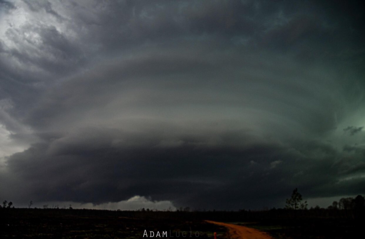
quote:
Adam Lucio
@AdamLucioWX
Sooo I don’t expect to see this often especially in Dixie Alley. This was the storm that produced the Silas, Alabama tornado, at this point it had wedged out and you can see it underneath.

Posted on 3/19/21 at 1:07 pm to Bobby OG Johnson
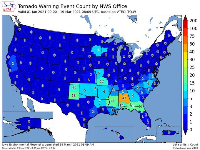
Wanted to share this and figured this thread was a good place for it as we look back at this event. This is the number of tornado warnings issued so far this year by National Weather Service office. So far NWS Birmingham has the big lead.
Posted on 3/19/21 at 9:29 pm to Roll Tide Ravens
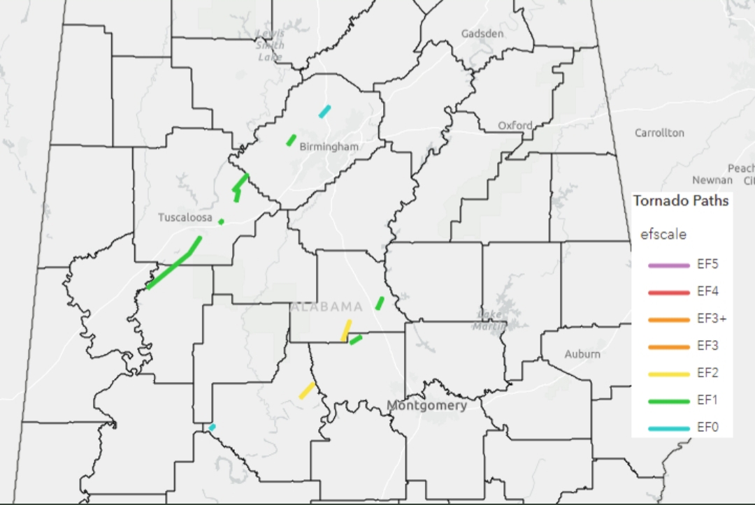
Latest survey info from @NWSBirmingham
All have been on the low end so far, and the rest should be, too. These have to be some of the more challenging (in terms of actually finding and tracking) damage surveys they've done in a while. It isn't like obvious damage from a large, long-track tornado. These storms cycled and put down multiple low-end tornadoes over hours and across miles and miles. It will probably take a few more days of working backwards from damage reports and a whole lot of riding around.
quote:
PRELIMINARY. This tally WILL go up. We stand at 11 confirmed tornadoes from Mar 17. We are still working on data tonight and have several more areas to survey this weekend. Strongest: 2 EF2 (yellow line). Longest path: 22 miles (Hale to Tuscaloosa County). LINK
All have been on the low end so far, and the rest should be, too. These have to be some of the more challenging (in terms of actually finding and tracking) damage surveys they've done in a while. It isn't like obvious damage from a large, long-track tornado. These storms cycled and put down multiple low-end tornadoes over hours and across miles and miles. It will probably take a few more days of working backwards from damage reports and a whole lot of riding around.

 Page 63 of 64

Popular
Back to top