- My Forums
- Tiger Rant
- LSU Recruiting
- SEC Rant
- Saints Talk
- Pelicans Talk
- More Sports Board
- Fantasy Sports
- Golf Board
- Soccer Board
- O-T Lounge
- Tech Board
- Home/Garden Board
- Outdoor Board
- Health/Fitness Board
- Movie/TV Board
- Book Board
- Music Board
- Political Talk
- Money Talk
- Fark Board
- Gaming Board
- Travel Board
- Food/Drink Board
- Ticket Exchange
- TD Help Board
Customize My Forums- View All Forums
- Show Left Links
- Topic Sort Options
- Trending Topics
- Recent Topics
- Active Topics
Started By
Message
re: Severe Weather Thread: 4/17 --Extra Bonus Easter Edition-- North LA and Northshore
Posted on 4/15/22 at 8:28 pm to LegendInMyMind
Posted on 4/15/22 at 8:28 pm to LegendInMyMind
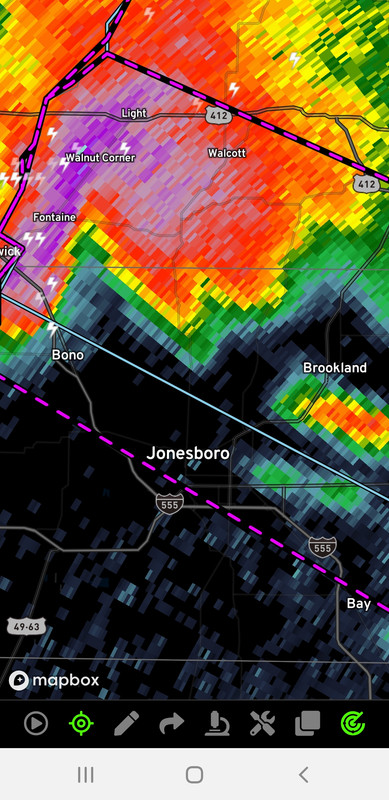
The town of Walnut Ridge must be gone. Jesus
 0
0


Posted on 4/15/22 at 8:28 pm to LegendInMyMind
Jonesboro has been smashed by multiple tornadoes throughout history
Posted on 4/15/22 at 8:28 pm to LegendInMyMind
There is some nasty looking cloud on the camera. Pretty sure there’s a walk cloud.
Posted on 4/15/22 at 8:29 pm to LegendInMyMind
4 INCH HAIL NOW and the tornado. Cars flipped on Hwy 67.
827 PM CDT Fri Apr 15 2022
...TORNADO EMERGENCY FOR SOUTHWEST GREENE AND CENTRAL CRAIGHEAD
COUNTIES...
...A TORNADO WARNING REMAINS IN EFFECT UNTIL 845 PM CDT FOR
SOUTHWESTERN GREENE AND CENTRAL CRAIGHEAD COUNTIES...
At 825 PM CDT, a confirmed large and destructive tornado was located
over Fontaine, or near Lake Frierson State Park, moving southeast at
45 mph. Cars have been flipped over on Highway 67 in Walnut Ridge.
TORNADO EMERGENCY includes Fontaine and Bono. This is a PARTICULARLY
DANGEROUS SITUATION. TAKE COVER NOW!
HAZARD...Deadly tornado.
SOURCE...Radar confirmed tornado.
IMPACT...You are in a life-threatening situation. Flying debris may
be deadly to those caught without shelter. Mobile homes
will be destroyed. Considerable damage to homes,
businesses, and vehicles is likely and complete destruction
is possible.
Locations impacted include...
Jonesboro, Paragould, Bono, Lake City, Bay, Brookland, Crowleys Ridge
State Park, Lake Frierson State Park, Walcott, Fontaine, Hergett,
Macey, Schug, Gum Point, Farrville, Dorothy, Lester, Light, Bethel
and Lanieve.
PRECAUTIONARY/PREPAREDNESS ACTIONS...
To repeat, a large, extremely dangerous, and potentially deadly
tornado is on the ground. To protect your life, TAKE COVER NOW! Move
to an interior room on the lowest floor of a sturdy building. Avoid
windows. If in a mobile home, a vehicle or outdoors, move to the
closest substantial shelter and protect yourself from flying debris.
&&
LAT...LON 3593 9086 3596 9086 3598 9084 3599 9086
3602 9084 3604 9084 3605 9083 3608 9082
3609 9080 3611 9077 3595 9033 3571 9048
3590 9087 3592 9087
TIME...MOT...LOC 0125Z 299DEG 40KT 3601 9083
TORNADO...OBSERVED
TORNADO DAMAGE THREAT...CATASTROPHIC
MAX HAIL SIZE...4.00 IN
Posted on 4/15/22 at 8:30 pm to LegendInMyMind
Buck Snort takes the win tonight.
Posted on 4/15/22 at 8:34 pm to LegendInMyMind
Camera is starting to shake
Posted on 4/15/22 at 8:34 pm to NorthEndZone
Wow.

Posted on 4/15/22 at 8:34 pm to LegendInMyMind
No visual confirmation at the moment. Warning has the Radar Confirmed tag now.
Posted on 4/15/22 at 8:35 pm to WhuckFistle
Link?
Posted on 4/15/22 at 8:36 pm to 9Fiddy
Idrivearkansas.com.
What are you on? Mobile or desktop?
What are you on? Mobile or desktop?
Posted on 4/15/22 at 8:36 pm to OSoBad
Grapefruit sized hail reported

Posted on 4/15/22 at 8:37 pm to OSoBad
quote:

Posted on 4/15/22 at 8:37 pm to WhuckFistle
Mobile
Posted on 4/15/22 at 8:37 pm to 9Fiddy
New warning is Radar Indicated.
Posted on 4/15/22 at 8:38 pm to 9Fiddy
Well go to that site on the bottom left, hit the traffic signal and then click on traffic cameras.
Posted on 4/15/22 at 8:38 pm to OSoBad
Son at Ar State, says everyone hunkered down
Posted on 4/15/22 at 8:38 pm to LegendInMyMind
New warning drops the hail to 2".
Posted on 4/15/22 at 8:40 pm to WhuckFistle
Found it. Thanks!
Posted on 4/15/22 at 8:40 pm to LegendInMyMind
Looks more like some strong arse straight line wind now matching velocity and CC

 Page 68 of 81

Popular
Back to top