- My Forums
- Tiger Rant
- LSU Recruiting
- SEC Rant
- Saints Talk
- Pelicans Talk
- More Sports Board
- Coaching Changes
- Fantasy Sports
- Golf Board
- Soccer Board
- O-T Lounge
- Tech Board
- Home/Garden Board
- Outdoor Board
- Health/Fitness Board
- Movie/TV Board
- Book Board
- Music Board
- Political Talk
- Money Talk
- Fark Board
- Gaming Board
- Travel Board
- Food/Drink Board
- Ticket Exchange
- TD Help Board
Customize My Forums- View All Forums
- Show Left Links
- Topic Sort Options
- Trending Topics
- Recent Topics
- Active Topics
Started By
Message
re: Severe Weather Thread: 4/17 --Extra Bonus Easter Edition-- North LA and Northshore
Posted on 4/15/22 at 8:10 pm to LegendInMyMind
Posted on 4/15/22 at 8:10 pm to LegendInMyMind
 1
1

Posted on 4/15/22 at 8:13 pm to Duke
quote:
Deltaland is the nostradumbass of the weather threads.
:(
Posted on 4/15/22 at 8:13 pm to deltaland
Wow, you couldn’t have hit that more on the head
Posted on 4/15/22 at 8:15 pm to deltaland
Remember, I'm only an a-hole to posters I like.
Posted on 4/15/22 at 8:15 pm to LegendInMyMind
How is there conditions good enough for a storm like this but hardly no other cells form?
shite is weird
shite is weird
Posted on 4/15/22 at 8:15 pm to Duke
The hail on that storm is unreal
Posted on 4/15/22 at 8:15 pm to LegendInMyMind
8:13pm Law Enforcement confirmed it is still on the ground.
Posted on 4/15/22 at 8:17 pm to deltaland
quote:
The hail on that storm is unreal
This is the most impressive, long-running hail core I have seen on a storm outside of TX/the Plains since I have been radar watching.

Posted on 4/15/22 at 8:18 pm to LegendInMyMind
Memphis split cutting dat PRF and making the Vmax dance
Posted on 4/15/22 at 8:18 pm to LegendInMyMind
That hail core is even showing up on the Composite Reflectivity of the local weather app.
Posted on 4/15/22 at 8:19 pm to LegendInMyMind
My weather job interviewer called my references the other day so that's good I guess
Posted on 4/15/22 at 8:21 pm to The Boat
quote:
My weather job interviewer called my references the other day so that's good I guess
Yeah, unless you put the OT down as a reference.
Posted on 4/15/22 at 8:21 pm to LegendInMyMind
This cell is about to max out the Radar Scope color chart
Posted on 4/15/22 at 8:21 pm to LegendInMyMind
I linked to my weather thread posts
Posted on 4/15/22 at 8:22 pm to LegendInMyMind
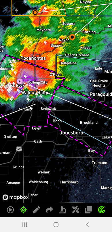
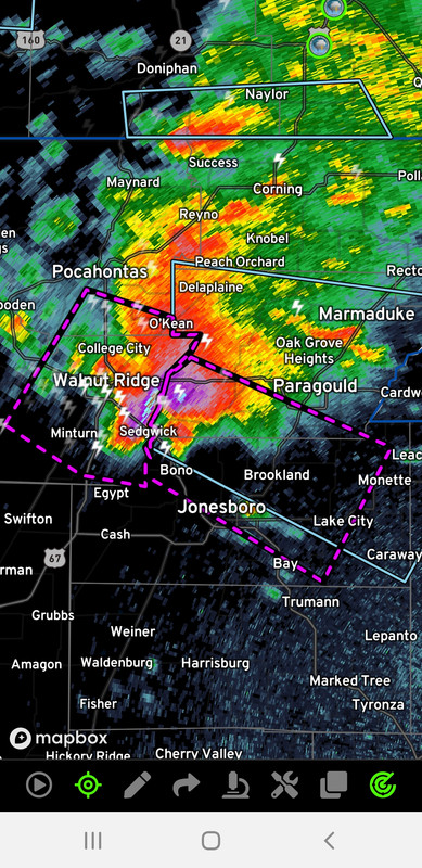
814 PM CDT Fri Apr 15 2022
...TORNADO EMERGENCY FOR SOUTHWESTERN GREENE AND CENTRAL
CRAIGHEAD COUNTIES...
...A TORNADO WARNING REMAINS IN EFFECT UNTIL 845 PM CDT FOR
SOUTHWESTERN GREENE AND CENTRAL CRAIGHEAD COUNTIES...
At 812 PM CDT, a confirmed large and destructive tornado was located
over Walnut Ridge, moving southeast at 50 mph. There have been
reports of power flashes in the Walnut Ridge area.
TORNADO EMERGENCY for FONTAINE AND BONO. This is a PARTICULARLY
DANGEROUS SITUATION. TAKE COVER NOW!
HAZARD...Deadly tornado.
SOURCE...Radar confirmed tornado.
IMPACT...You are in a life-threatening situation. Flying debris may
be deadly to those caught without shelter. Mobile homes
will be destroyed. Considerable damage to homes,
businesses, and vehicles is likely and complete destruction
is possible.
Locations impacted include...
Jonesboro, Paragould, Bono, Lake City, Bay, Brookland, Crowleys Ridge
State Park, Lake Frierson State Park, Walcott, Fontaine, Hergett,
Macey, Schug, Gum Point, Farrville, Dorothy, Lester, Light, Bethel
and Lanieve.
PRECAUTIONARY/PREPAREDNESS ACTIONS...
To repeat, a large, extremely dangerous, and potentially deadly
tornado is on the ground. To protect your life, TAKE COVER NOW! Move
to an interior room on the lowest floor of a sturdy building. Avoid
windows. If in a mobile home, a vehicle or outdoors, move to the
closest substantial shelter and protect yourself from flying debris.
&&
LAT...LON 3593 9086 3596 9086 3598 9084 3599 9086
3602 9084 3604 9084 3605 9083 3608 9082
3609 9080 3611 9077 3595 9033 3571 9048
3590 9087 3592 9087
TIME...MOT...LOC 0112Z 297DEG 45KT 3607 9096
TORNADO...OBSERVED
TORNADO DAMAGE THREAT...CATASTROPHIC
MAX HAIL SIZE...3.00 IN
Posted on 4/15/22 at 8:23 pm to LegendInMyMind
Watching another camera and the tornado should go right in front of this one.

Posted on 4/15/22 at 8:23 pm to WhuckFistle
We hit 80 dbz
Posted on 4/15/22 at 8:25 pm to The Boat
quote:
We hit 80 dbz
It has hit it a few times. This is a hell of a storm.

 Page 67 of 81

Popular
Back to top