- My Forums
- Tiger Rant
- LSU Recruiting
- SEC Rant
- Saints Talk
- Pelicans Talk
- More Sports Board
- Fantasy Sports
- Golf Board
- Soccer Board
- O-T Lounge
- Tech Board
- Home/Garden Board
- Outdoor Board
- Health/Fitness Board
- Movie/TV Board
- Book Board
- Music Board
- Political Talk
- Money Talk
- Fark Board
- Gaming Board
- Travel Board
- Food/Drink Board
- Ticket Exchange
- TD Help Board
Customize My Forums- View All Forums
- Show Left Links
- Topic Sort Options
- Trending Topics
- Recent Topics
- Active Topics
Started By
Message
 2
2

Posted on 3/14/25 at 11:05 am to Funky Tide 8
Well, so am I but Im not sleeping in a vehicle in a pine forest during severe weather. Maybe I will he just text me saying he found the motherload
Posted on 3/14/25 at 11:06 am to Old Man and a Porch
quote:
Is Louisiana out of the picture?
Come on man
Posted on 3/14/25 at 11:07 am to Old Man and a Porch
The picture is one page back for reference

Posted on 3/14/25 at 11:09 am to LSUBALLER
quote:
Thanks so Slidell screwed
Yes, but there will also be bad weather.

Posted on 3/14/25 at 11:14 am to LegendInMyMind
quote:
My hope is that all the usual suspects are in here late tomorrow night laughing about this being a bust and much ado about nothing.
Nothing would make me happier.
Agreed. Annoying as it may be, I’d rather listen to people whine about nothing happening (as though it’s a bad thing) than talk about death and destruction.
Posted on 3/14/25 at 11:15 am to Roll Tide Ravens
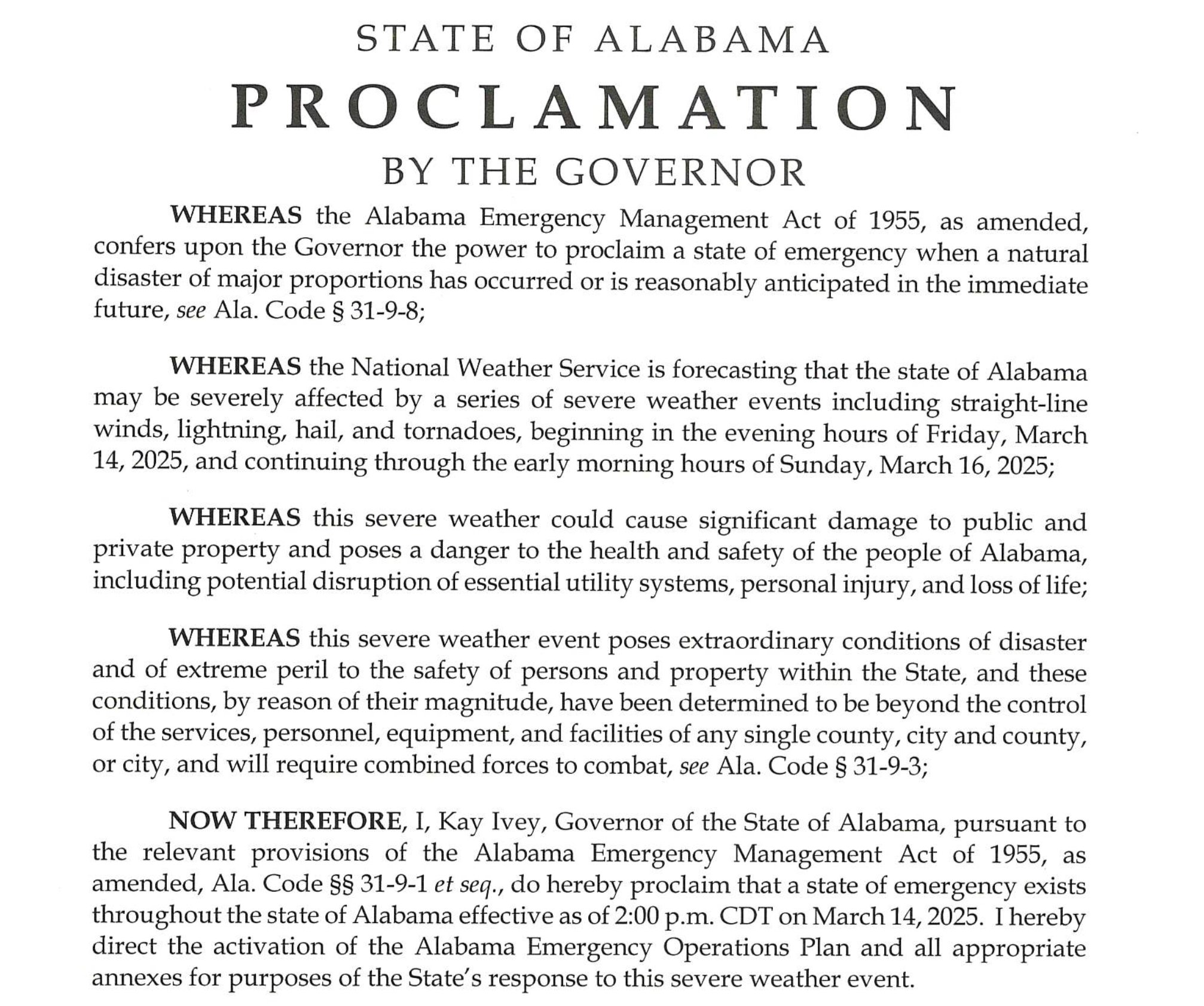
Alabama Governor Kay Ivey has declared a statewide state of emergency for Alabama ahead of the severe weather outbreak:
Loading Twitter/X Embed...
If tweet fails to load, click here. Posted on 3/14/25 at 11:16 am to Chicken
quote:
or we can leave this thread, but I do not want to sticky a thread like this with a stale first page...
I’ll start a new one.
Posted on 3/14/25 at 11:20 am to public_enemy
quote:
What can we expect in West Baton Rouge with this system
Depression and trashy women. Could be some severe weather too.
Posted on 3/14/25 at 11:27 am to Roll Tide Ravens
quote:
people whine about nothing happening (as though it’s a bad thing)
Being accurate in predictions is expected in virtually every profession. Meteorology isn't some special exception. People are replanning trips, closing businesses, opening storm shelters, cancelling events. All this costs money and resources.
Posted on 3/14/25 at 11:38 am to Roll Tide Ravens
quote:
This is the most concerning severe weather threat/setup for Mississippi and Alabama that I can remember since 4/27/2011. I’m not saying that tomorrow will be at that level, but it’s very concerning.
Not trying to be “that guy” but the ingredients are very close to the same. It is concerning I’m shocked there isn’t a high threat yet
Tomorrow
quote:
The exit region of the mid-level jet streak is forecast to move across the lower Mississippi Valley and Tennessee during the mid to late afternoon, which will be timed well with afternoon max heating. Forecast soundings at 21Z across parts of southern and central Mississippi have MLCAPE in the 2000 to 3500 J/kg range, with 0-6 km shear of 70 to 80 knots. 700-500 mb lapse rates are forecast to be near 8 C/km, with 0-3 km storm-relative helicity in the 400 to 500 m2/s2 range. This will be very favorable for intense severe storms, with a threat for tornadoes, wind damage and large hail. Several tornadic supercells are expected to develop within this cluster by mid to late afternoon as the low-level jet intensifies. Multiple long-track high-end tornadoes will be possible. The greatest tornado threat is expected to shift into Alabama by early to mid evening, with a significant tornado threat also impacting parts of middle Tennessee.
For comparison, April 27 SPC outlook day 1
quote:
A LARGE MCS IS ONGOING ACROSS THE TN VALLEY. THIS CONVECTIVE SYSTEM IS TIMED TO MOVE INTO ERN TN AND NW GA BY 21Z. MESOANALYSIS SHOWS A RESERVOIR OF MODERATE INSTABILITY FROM LA EXTENDING EWD ACROSS SCNTRL MS WHERE MLCAPE VALUES ARE ESTIMATED IN THE 2000 TO 3000 J/KG RANGE. THIS MODERATE INSTABILITY SHOULD BE TRANSPORTED NEWD INTO THE HIGH RISK AREA THIS AFTERNOON AS THE MCS EXITS THE REGION TO THE EAST. AS THE THERMODYNAMIC SETUP IMPROVES...THE WIND SHEAR ENVIRONMENT WILL ALSO RAPIDLY BECOME MORE FAVORABLE AS THE NOSE OF A 80 TO 100 KT MID-LEVEL JET EJECTS EWD ACROSS THE REGION AND INTERACTS WITH A WELL-DEVELOPED LOW-LEVEL JET. THIS WILL CREATE LARGE LOOPING HODOGRAPHS FROM ERN MS AND NCNTRL AL NWD INTO SRN TN. 0-3 KM STORM RELATIVE HELICITIES IN THE 450 TO 600 M2/S2 RANGE SHOULD BE VERY FAVORABLE FOR TORNADIC SUPERCELLS. THE CURRENT THINKING IS THAT THE GREATEST TORNADO POTENTIAL WILL EXIST LATE THIS AFTERNOON AND EARLY THIS EVENING FROM COLUMBUS MS EWD TO BIRMINGHAM AND HUNTSVILLE AL. THIS AREA IS CURRENTLY SOUTH OF THE ONGOING MCS WHERE DESTABILIZATION SHOULD BE MOST FAVORABLE. AS SUPERCELLS INITIATE IN ERN MS AND TRACK ENEWD ACROSS THE HIGH RISK AREA LATE THIS AFTERNOON...A TORNADO OUTBREAK IS EXPECTED. A FEW LONG-TRACK STRONG TORNADOES AND POSSIBLY A VIOLENT TORNADO OR TWO MAY OCCUR AS THE LOW-LEVEL JET STRENGTHENS EARLY THIS EVENING.
Shear and Helicity values were slightly stronger on April 27,2011 but tomorrows system is probably the closest we have had to that outbreak since.
Posted on 3/14/25 at 11:57 am to Park duck
quote:
My youngest is home for spring break and was talking about sleeping in his truck(national forest) turkey season starts tomorrow.
My youngest did that last year in Appilachicola NF and killed the battery in his truck in middle of nowhere. Mom called me in a panic while I'm at the top of pulp mill digester in middle of MS. Told her he'd figure it out. Came home eventually with tail tucked between his legs and no birds

Posted on 3/14/25 at 12:08 pm to EagleEye99
This thread is now anchored. Please use the sticky thread. Thanks.

 Page 21 of 21


Back to top