- My Forums
- Tiger Rant
- LSU Recruiting
- SEC Rant
- Saints Talk
- Pelicans Talk
- More Sports Board
- Coaching Changes
- Fantasy Sports
- Golf Board
- Soccer Board
- O-T Lounge
- Tech Board
- Home/Garden Board
- Outdoor Board
- Health/Fitness Board
- Movie/TV Board
- Book Board
- Music Board
- Political Talk
- Money Talk
- Fark Board
- Gaming Board
- Travel Board
- Food/Drink Board
- Ticket Exchange
- TD Help Board
Customize My Forums- View All Forums
- Show Left Links
- Topic Sort Options
- Trending Topics
- Recent Topics
- Active Topics
Started By
Message
re: Severe Weather: May 19-20, 2025
Posted on 5/20/25 at 6:36 pm to Wishnitwas1998

Posted on 5/20/25 at 6:36 pm to Wishnitwas1998
Still on the ground in Madison.
This post was edited on 5/20/25 at 6:37 pm
 1
1

Posted on 5/20/25 at 6:37 pm to Roll Tide Ravens
Good quality north Alabama tornado coverage:
Posted on 5/20/25 at 6:38 pm to Roll Tide Ravens
That's what I'm watching right now. Dude running the radar is basically from Madison and knows everything about the place
Posted on 5/20/25 at 6:39 pm to Roll Tide Ravens
Posted on 5/20/25 at 6:39 pm to Roll Tide Ravens
Posted on 5/20/25 at 6:40 pm to Wishnitwas1998
Now one headed towards me from the south. Not warned yet.
Posted on 5/20/25 at 6:42 pm to LegendInMyMind
I wouldn’t be shocked if there are 2-3 different tornadoes with this Madison/Huntsville storm. Looks like there is additional rotation north of where the tornado is. Kind of confusing.
Posted on 5/20/25 at 6:43 pm to LegendInMyMind
Yeah, the storm south of Decatur is ramping up rotation wise.
Posted on 5/20/25 at 6:45 pm to Roll Tide Ravens
This post was edited on 5/20/25 at 6:46 pm
Posted on 5/20/25 at 6:46 pm to Roll Tide Ravens
Posted on 5/20/25 at 6:47 pm to LegendInMyMind
Reed is a crazy SOB 
Posted on 5/20/25 at 6:48 pm to Roll Tide Ravens
Reed Timmer just took a sub vorticy tornado directly to the side of the Dominator.
That was effing nuts.
That was effing nuts.

Posted on 5/20/25 at 6:48 pm to Roll Tide Ravens
Guy commenting how crazy the people are on 565 lol.
Posted on 5/20/25 at 6:48 pm to Roll Tide Ravens
For the Huntsville tornado:
Tornado Warning
National Weather Service Huntsville AL
644 PM CDT Tue May 20 2025
The National Weather Service in Huntsville Alabama has issued a
* Tornado Warning for... Northwestern Jackson County in northeastern Alabama... Central Madison County in north central Alabama...
* Until 730 PM CDT.
* At 644 PM CDT, a confirmed large and extremely dangerous tornado was located over University Of Alabama In Huntsville, or near Huntsville, moving east at 30 mph.
This is a PARTICULARLY DANGEROUS SITUATION. TAKE COVER NOW!
HAZARD...Damaging tornado.
SOURCE...Emergency management confirmed tornado.
IMPACT...You are in a life-threatening situation. Flying debris may be deadly to those caught without shelter. Mobile homes will be destroyed. Considerable damage to homes, businesses, and vehicles is likely and complete destruction is possible.
* The tornado will be near... Alabama A And M University, Moores Mill, and Huntsville around 650 PM CDT.
Other locations impacted by this tornadic thunderstorm include Maysville, Princeton, Estillfork, Pleasant Groves, Trenton, Garth, Ryland, Hollytree, Brownsboro, and Larkin.
Posted on 5/20/25 at 6:49 pm to razorbackfan4life
quote:
Reed Timmer just took a sub vorticy tornado directly to the side of the Dominator.
Hell, I almost took it to the side of the house.
Posted on 5/20/25 at 6:49 pm to Zchlsu
quote:
Guy commenting how crazy the people are on 565 lol.
Can confirm. That is any random Tuesday, though.
Posted on 5/20/25 at 6:49 pm to LegendInMyMind
quote:
Hell, I almost took it to the side of the house.
I haven't been keeping up with the weather today.
How close was it?
Posted on 5/20/25 at 6:51 pm to LegendInMyMind
Those guys have big balls. I guess being pros and all that they could tell it wasn’t all that strong, but damn.
Posted on 5/20/25 at 6:52 pm to Roll Tide Ravens
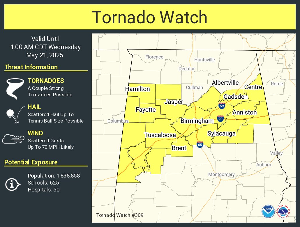
Just got the tornado watch for Central Alabama

Posted on 5/20/25 at 6:52 pm to Roll Tide Ravens
Loading Twitter/X Embed...
If tweet fails to load, click here. Wow insane video

 Page 11 of 16

Popular
Back to top